Alan Snyder
@AlanSevere
Owner of Forecast Frontier, Weather Lover. For discussions and friendly environment checkout FF on discord. https://discord.gg/gXmcXNRm5v
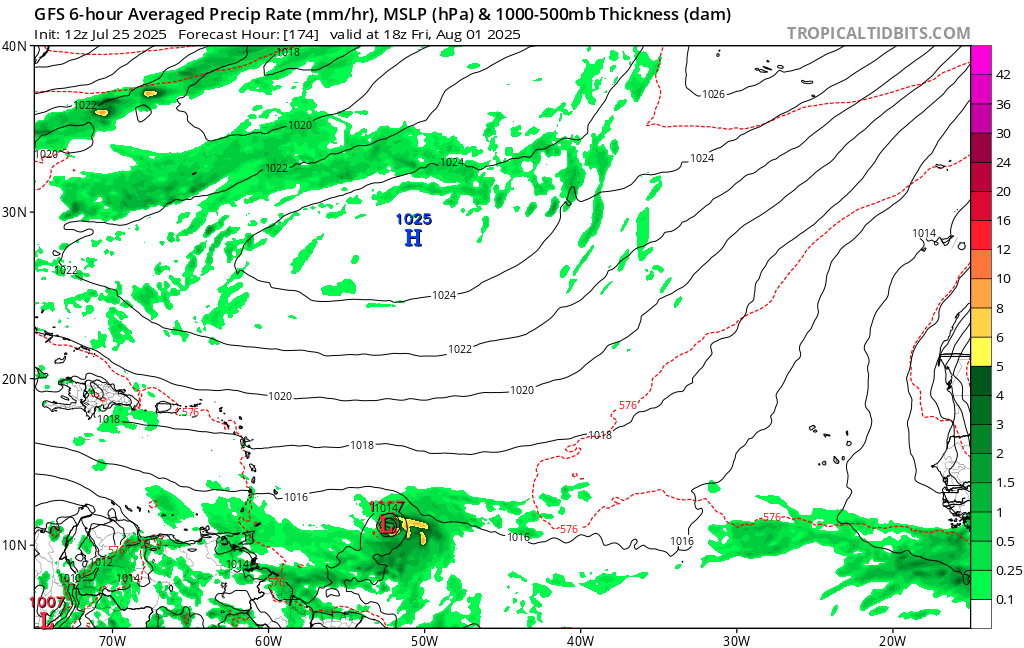
Latest 12z GFS has a sub 1000 mb low slipping into the Caribbean a day or so into August.
African Easterly Wave season is ramping up. These storm seedlings emerge from Africa's Sahel region from June to October and are key factors in the development of hurricanes. Models are picking up on a stronger wave next week that bears watching into early August.
While tropical storm Krosa remains heavily sheared at the outflow layer due to the remnants of Francisco to the west, some organization has occurred in the low-levels where flow is more unidirectional. Microwave imagery from 03z reveals a curved band structure wrapping into the…
Maybe something to watch next week. NHC has not outlooked this area as of the time of this post.
Notably, the data has taken a fairly uniform step back with their solutions from yesterday for the MDR disturbance. Models are only a tool in our box for tropical meteorology. Posting select graphics from a single deterministic run without further commentary is not something…
Development of a Tropical wave that will move off of Africa next week is becoming possible, while the NHC is yet to officially tag anything, Determanistic (Long range) runs have shown promise, and Ensemble support has been steady for the last~24 hours. Something to watch #Tropics
Here is today's EPS still has a decent cluster of members that want to try to do something with it. There are somethings it needs to deal with first like dry air and movement speed, but over all models are still sniffing it out. The Wave in question splashes down on Monday.
It also comes off with a pretty appreciable TEJ surge, wonder if that'll not only increase favorable divergence over the wave but also offset deep-layer shearing when ridging accelerates it later.
00z vs. 12z Euro illustrates one of the big challenges for potential development in the MDR late next week: maintaining convection. Stability and dry air will make it challenging for the system to do that, which could limit how much it develops before the islands. That'll be a…
Euro shows no development in the next 7 days. But does try to form it past day 10.
I would not be surprised to see the NHC mark an area of interest in the eastern #Atlantic sometime over the next few cycles as a vigorous low-latitude wave attempts to consolidate. We will have to monitor how strong the disturbance becomes initially, as a deeper vort will take a…
Models are starting to come into agreement that potentially into next week, we will likely see tropical development in this region of the MDR.
12 Z Models are starting to come in, and it looks like GFS formly develops the wave in question in around the day 7 mark. CMC starting to show the wave now even tho it is weak and doesn't form it. We will take a look at the Euro once it comes out.
Thursday evening discussion on the state of the Atlantic tropics as we round out July. Mixed signals with some large-scale hostile conditions out there, but also hints of things waking up as we head into August. youtu.be/8JhbbEBoMv8
I'm following this with you. A vigorous tropical wave will emerge from Africa from Sunday to Monday. It could find favorable conditions for its development. #DominicanRepublic #Hurricaneseason
Estoy siguiendo esto con ustedes, una vigorosa onda tropical saldrá de África de Domingo a Lunes, esta podría encontrar condiciones favorables para su desarrollo. Un sistema antes que esté en el Atlántico medio podría significar una amenaza también... #tropicos #puertorico #RD
#Co-May is currently making landfall in northwestern Luzon. Peaking as a typhoon, it has since weakened, and is expected to further drop in intensity as the terrain disrupts the system. Afterwards, #Co-May will move to the north-northeast.
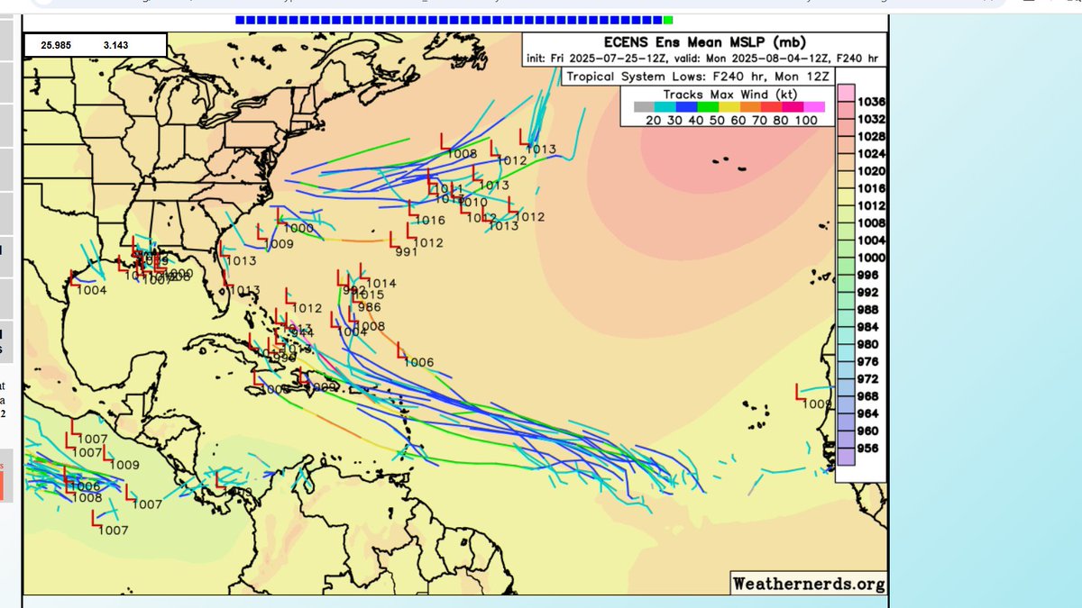
Latest 12Z ECMWF ensembles are lighting up for the long range. Shows a 40-55% probability of a tropical depression forming in the MDR by August 1st. The spaghetti plot also shows a variety of potential tracks, generally WNW towards the Caribbean and Bahamas. There's still a huge…
New signal for potential development looming from a AEW in the MDR. Inconsistency in models to indicate where this is headed in the medium to long range but generally would reach the Lesser Antilles. A signal to analog the potential for waves to be more “home-grown”. #wx #tropics
EPS and AIFS ens plus the AIFS operational models have really taken a shining to a signal in the next 7 to 10 days near the islands. Could get some help from a CCKW when it nears the islands as well. Will keep you all updated
We are watching two areas in the tropics with a 10/10 AOI in the gulf area and potential MDR development for next week, as 12z ensemble model runs have had a noticeable uptick. For the 10/10 AOI, models continue not to show much, and things have had little improvement since it…
Went over this signal in my video discussion today… youtu.be/hmXTixbYs8w?si…
A vigorous tropical wave bears watching as it approaches the Lesser Antilles towards the end of next week. EURO Ensembles and the highly-touted Google AI are starting to sniff out tropical mischief. A reminder that August is right around the corner. Next name is #DEXTER. 🌀