
Mitch West
@SCweather_wx
Mitch West ~ Weather enthusiast ~ Storm chaser ~ YouTuber! ~ Follow along for updates!
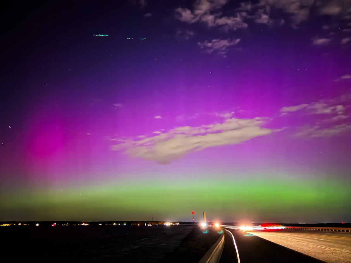
What an incredible experience that I’ll never forget. There was no hype or lead up excitement for me with this event. I just thought to myself on the way home from work this afternoon how cool it would be to see some colors in the sky tonight.. And then tonight happened. The…

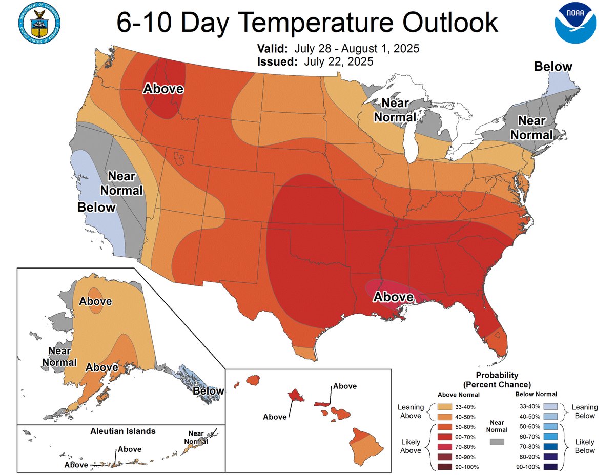
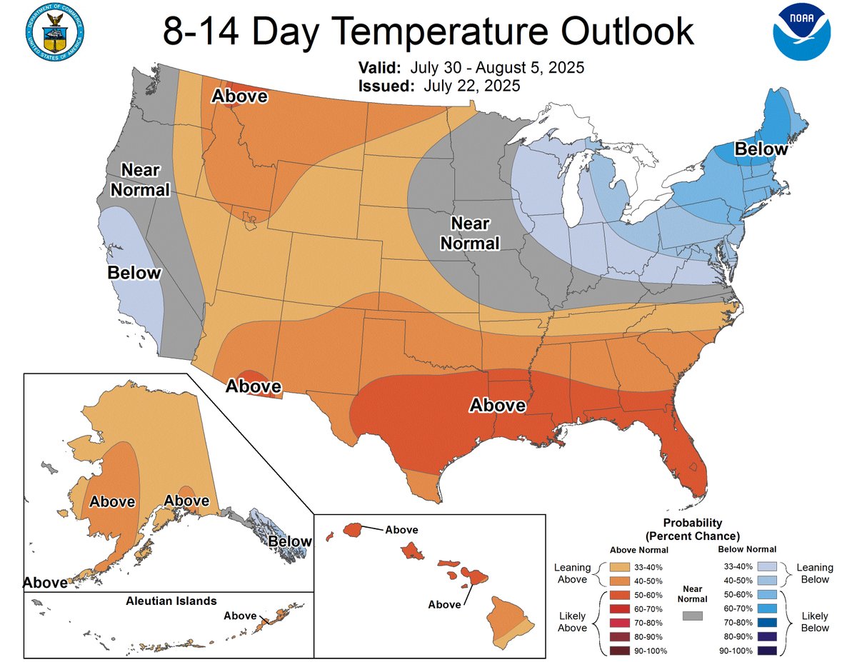
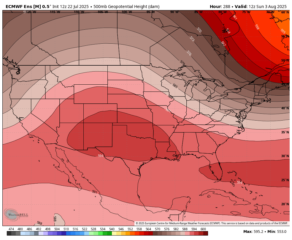
I fear this Summer ain’t even close to done with the brutal heat. Despite what people think, August has not been a terrible month heat wise for several years now. People are use to saying it’s the hottest month around here, but I got a feeling it’s hot this year.
Do you see August also being a scorcher for the Carolinas? Was hoping July would be a closer to average month…
CAE issues Flood Advisory for Calhoun, Lexington, Richland [SC] till Jul 22, 10:30 PM EDT mesonet.agron.iastate.edu/vtec/f/2025-O-…

Hardest I’ve seen it rain in years. Insane PWAT values with this. Goodness.
Doinks
8pm EDT 22 July -- A trough of low pressure, currently located off the SE U.S. coast is forecast to move into the North-Central Gulf, and has a low chance (10%🟡) of tropical cyclone formation before it moves inland by this weekend. Latest Outlook: hurricanes.gov/gtwo.php?basin…
Can’t wait to post this banger when we begin to reverse the trend of reeling back in a Winter Storm inside 60 hours again.
On average, 86% of all named tropical systems in the Atlantic occur after August 2, and the first hurricane doesn't form until August 11. We have a long season to go. Prepare now, and learn more about how at weather.gov/safety/hurrica…
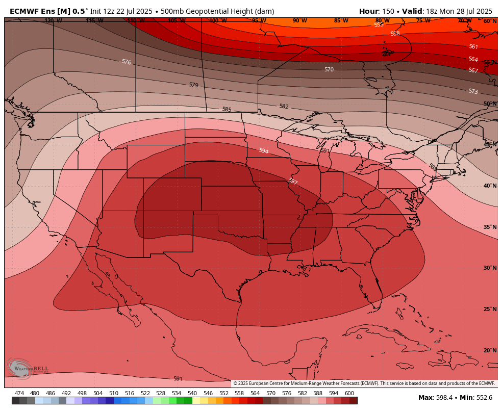
Medium to long range pattern continues to look very hot to round off August. Only areas that look to dodge the worst of the heat is the Northeast where dips in the jet will allow for cool downs. As we get a few days into August, maybe the ridge gets beat down enough for some…
The latest Global Tropics Hazards Outlook has highlighted both the Gulf and Atlantic sides of Florida for a low chance of tropical cyclone formation possibility between July 30 and August 5. The following week is looking quiet basin-wide. Keep watching.
If we somehow wiff the breeze & the cold front convection today, I might go outside & punch air.
A cold front and the sea breeze will work together to produce storms this afternoon and evening. Rain will likely be most widespread in the southern Midlands.
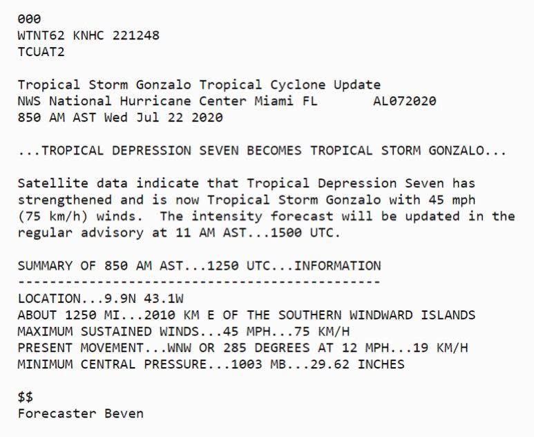
In 2020, we were already smoking through the alphabet. What a ridiculous hurricane season.

Me talking severe weather on my YouTube for 4 months straight now.
We will rage soon.
Word is out—we've released our initial 2025 fall foliage predictions! It's important to remember that at this point in the season, our maps try to depict "normal" timing. As fall approaches, we begin to fine tune the forecast to match regional anomalies!
60 days away (Sep 20th) ...from the start of the color season for the Southern Section. Nothing widespread, mostly summer green transitioning to a faded/lime green above 5000'
Finally can see the sky again! 54F at 8am, 1017mb, nutin' but blue skies😎