Jeremy DeHart
@JeremyDeHartWX
Meteorologist & @53rdWRS Hurricane Hunter. Alum of @NPS_Monterey (M.S.) | @NCState @ncstatemeas (B.S.) | Views do not represent those of the Air Force or DoD.
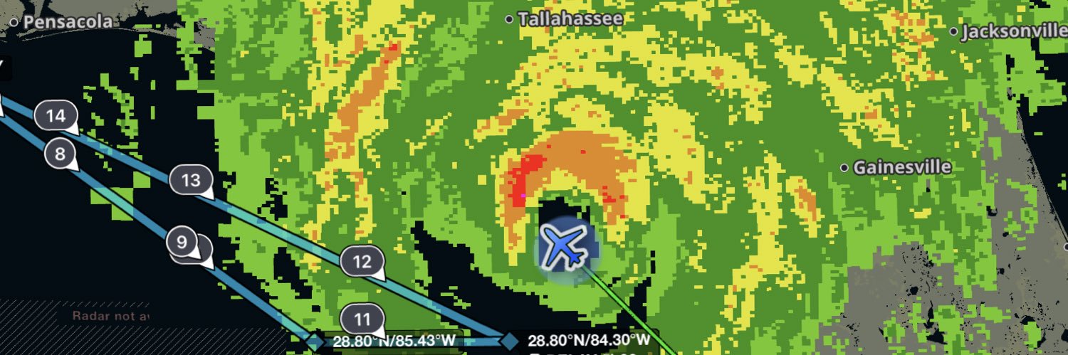
(1/3) #Michael at landfall. The normal "stadium effect" was more like a cylinder, a straight vertical wall 50K ft high. Saw 175 mph flight level winds, ~155 mph at surface. Entered eyewall at 10K ft, ended up in eye down at 8K! Need another tweet to explain what that felt like…
Another EPAC cyclone blowing up before landfall. Pressure in Hurricane #Erick dropped rapidly from 977mb to 972mb between passes (from center dropsondes). Closed eye was really wrapping up the second time through. Next @53rdWRS mission will be in the storm this evening.


Even though 93L is no more we could deal with some of its DNA next week AGAIN in nearly the same area. Strengthening ridging over the central USA may induce another vorticy streamer in the central Gulf that could slowly develop off an old boundary. Other areas are also starting…
Regardless of how much #93L develops, flood-producing rain is likely on the northern Gulf coast toward the end of the week.
⚠️ First Alert - flood concerns growing for later this week in association with Invest #93L. A Level 3/4 (moderate) risk of flooding is now posted for Friday for parts of the area. The updated outlook from @NWSWPC now shows totals averaging 4"-7" across much of south Louisiana…
👇
Is anyone else’s husband ranting about how the format of the Home Run Derby has changed so much since we were younger and how it used to be so fun to watch and now it sucks and is basically unwatchable but is still watching it
I am so over this nonsense. 365K followers on this. For those of who can still think critically, I promise you there is always an explanation in between "climate emergency" and "the clouds are attacking us." Please take back the conversation and don't feed into the clickbait.

2pm EDT July 12th - An area of low pressure could develop off the SE U.S. coast & now has a low chance (20%🟡) of TC formation as it moves generally westward across the Florida Peninsula into the north-central portion of the Gulf. Latest Outlook: hurricanes.gov/gtwo.php?basin…
2pm EDT July 12th - An area of low pressure could develop off the SE U.S. coast & now has a low chance (20%🟡) of TC formation as it moves generally westward across the Florida Peninsula into the north-central portion of the Gulf. Latest Outlook: hurricanes.gov/gtwo.php?basin…
Was walking down the candy aisle once picking up some snacks for a flight and a kid grabbed some Dots right in front of me. Her mom says "not those, Dots are gross!" I looked her square in the eye and said "I love them!" and snagged a box. Plus only 95c at the commissary 🤌 GOAT.
What's the candy you have to buy when you see it because you never see it? Dots for me. Goated. Don't tell my dentist.
Interestingly, late July/early August ACE is one of the most positively correlated periods with elevated hurricane activity over the rest of the season. Likely linked to 30-60 day period of the MJO➡️higher probability of favorable conditions in late Aug/early Sept season peak.
A convective pulse is forecast to move across the Atlantic into Africa during late July and early August, potentially bringing the season's first chance for a hurricane.
CSU reduces seasonal #hurricane forecast a bit but still predicts slightly above-normal Atlantic season, with 16 named storms, 8 hurricanes and 3 major (Category 3+ hurricanes): tropical.colostate.edu/Forecast/2025-… Relatively warm Atlantic and likely absence of #ElNino the primary factors.
Just returned home. Good explainer on why #Chantal threw us a curve on the 2nd fix. Was expecting it to be NNW of the 1st fix, but got an abrupt wind flip to the NE, so had to circle and reattack from the S. Maybe this means track toward the right side of the cone? Tricky storm!
Deep convection east of the center of #Chantal is causing stronger pressure falls which is elongating and pulling the low-level center NE closer to the tilted mid-level center of the storm. This is how TCs attempt to remedy the negative effects of wind shear and reorganize.
NHC will initiate advisories on Tropical Depression Three, located in the Atlantic Ocean offshore of the southeastern United States, at 500 PM EDT (2100 UTC).
TEAL 71 is now enroute to investigate #92L. Three more @53rdWRS missions on the books through the weekend. USA airpower at work. Happy Independence Day 🇺🇸


Life of a hurricane hunter…no holiday weekend goes unpunished.
The National Hurricane Center has increased chances that sometime after the July 4th holiday, there could be a brief cyclone that forms off the Southeast coast. Latest forecast: foxweather.com/weather-news/f…
Not all pilots, but many, are fascinated by the science of meteorology, for obvious reasons. I think we spent at least a week on it in ground training at pilot training. This is pretty cool!
probably one of the cooler boundary collisions this year just now in the TX Panhandle #TXwx
There is nothing like American airpower.
The U.S. Air Force B-2A “Spirit” Long-Range Stealth Bombers that struck the Iranian nuclear sites early Sunday flew non-stop for about 37 hours from Whiteman Air Force Base in Missouri, refueling several times mid-air, a U.S. official told the New York Times.
We'll take it. Signed, Everyone
The Atlantic Basin looks like a ghost town through the end of June. It would be the first June without a storm since 2019 and the quietest start since the 2014 hurricane season. First name on the list is #ANDREA. #TropicalUpdate 💤😴🌀
⛈ Reserve Hurricane Hunters Take Flight! Our Air Force Reserve 53rd Weather Reconnaissance Squadron took off for its first mission of the 2025 hurricane season—tasked to fly Hurricane Erick, the Hurricane Hunters gather vital weather data to send to the @NWSNHC, which assists…
What just happened to end the 2nd round of the US Open at Oakmont?? Bad timing with this storm. But Thriston Lawrence was lining up his putt on 18 when they blew the horn. Now he has to finish early in the morning then wait *6 HOURS* to start his 3rd round. Let the guy finish!
