Philip Klotzbach
@philklotzbach
Meteorologist at CSU specializing in Atlantic basin seasonal hurricane forecasts. Avid runner, cyclist and hiker. Appalachian Trail thru-hiker in 2002.

CSU's four analogs for the 2025 Atlantic seasonal #hurricane forecast are: 2001, 2008, 2011, and 2021. Analogs selected had either ENSO neutral or weak #LaNina conditions and warmer tropical Atlantic anomalies relative to tropical Pacific anomalies for August-October.


Thanks to generous support from @iiiorg , @IAA_Auctions , @commoditywx , @IronshoreInc , @GallagherRe_ and @theWeatherboy that allow CSU's #hurricane forecasts to continue.

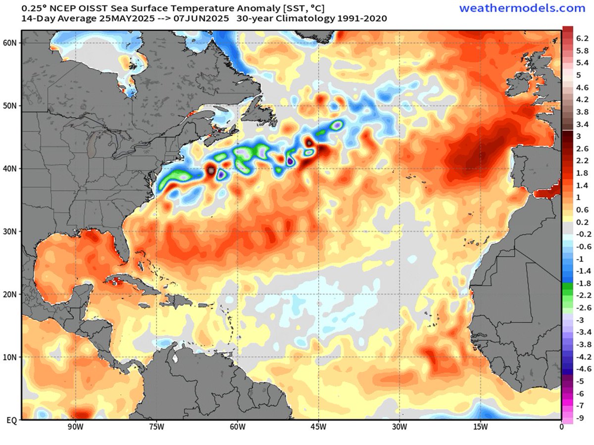
The subtropical eastern Atlantic and portions of the tropical Atlantic are warmer than normal. The current Atlantic sea surface temperature pattern is fairly similar to what we typically observe in July prior to active Atlantic #hurricane seasons.


One reason for CSU's active Atlantic #hurricane season forecast is anticipated lack of #ElNino. El Nino typically decreases Atlantic hurricane activity via increases in Caribbean/tropical Atlantic vertical wind shear. Lack of El Nino typically results in busier Atlantic seasons.


The main reason for CSU's slight reduction in their Atlantic seasonal #hurricane forecast is due to strong observed and forecast Caribbean shear. Strong Caribbean shear in June-July is typically associated with reduced Atlantic hurricane activity.


CSU reduces seasonal #hurricane forecast a bit but still predicts slightly above-normal Atlantic season, with 16 named storms, 8 hurricanes and 3 major (Category 3+ hurricanes): tropical.colostate.edu/Forecast/2025-… Relatively warm Atlantic and likely absence of #ElNino the primary factors.

Tropical Storm #Chantal has formed off of the southeast US coast. On average, the 3rd Atlantic named storm forms on August 3rd.
Tropical Storm #Barry has formed in the Bay of Campeche. On average, the 2nd Atlantic named storm forms on 17 July.
Tropical Storm #Andrea has formed east of Bermuda - the first Atlantic named storm of the 2025 Atlantic #hurricane season. On average the first Atlantic named storm forms on 20 June.
CSU's five analogs for the 2025 Atlantic seasonal #hurricane forecast are: 1996, 1999, 2008, 2011, and 2021. Analogs are selected based on 2nd hurricane season following #ElNino and warmer tropical Atlantic anomalies relative to tropical Pacific anomalies for August-October.


CSU's June 2025 seasonal #hurricane forecast press release has been translated into Spanish: tropical.colostate.edu/Forecast/2025-… Thanks to @Delian_wx and @NicholasAMesa1 for the translation!
The Caribbean and subtropical eastern Atlantic are warmer than normal, while eastern tropical Atlantic is near average. The current Atlantic sea surface temperature pattern is fairly similar to what we typically observe in June prior to active Atlantic #hurricane seasons.


Thanks to generous support from @iiiorg, @IAA_Auctions, @commoditywx, @IronshoreInc, @GallagherRe_ and @theWeatherboy that allow CSU's #hurricane forecasts to continue.

One reason for CSU's active Atlantic #hurricane season forecast is the unlikelihood of #ElNino. El Nino typically decreases Atlantic hurricane activity via increases in Caribbean/tropical Atlantic vertical wind shear. Lack of El Nino typically results in busier Atlantic seasons.


Atlantic seasonal #hurricane forecast update from @ColoradoStateU continues call for an above-normal season: 17 named storms, 9 hurricanes & 4 major hurricanes. Relatively warm Atlantic and likely absence of #ElNino are the primary factors. tropical.colostate.edu/Forecast/2025-…

Colorado State University will be issuing an updated Atlantic seasonal #hurricane forecast tomorrow, 11 June at 11am EDT.