Jeff Frame
@VORTEXJeff
Teaching associate professor of atmospheric sciences at the University of Illinois. I teach weather. Storm chaser. PhD, MS PSU; BS Michigan. All opinions mine.
100+ mph winds possible for parts of the Dakotas and Minnesota tomorrow associated with a developing convective cluster and could-be derecho. A shortwave trough riding the ridge, responsible for the heat across the plains, should induce thunderstorm development fairly early in…
Lack of strong forcing has definitely been a factor. It has been long stretches of just large scale general troughing. When you don't have mega troughs or high amplitude patterns, you don't have the surging fronts. While some of the epic outbreaks of the past that got most of us…
NWS is hiring! The first of several top-priority, mission-critical positions posted Friday on USAJobs.gov! Others will follow soon. Visit and search “NWS” to learn more.
Modeled soundings this evening are starting to exhibit classic derecho features. Notably, very deep low-level moisture yielding pwat values near 2.0" below an EML providing instability for leading thunderstorms but also mid-level dry air for rear inflow jet thermodynamics.
Derecho possible today
12:58am CDT #SPC Day1 Outlook Moderate Risk: for portions of eastern South Dakota into far western Minnesota spc.noaa.gov/products/outlo…
Let's talk about the forecast for the next few days. We're going to briefly be in a pattern called the "Ring of Fire," whereby clusters of storms parade around a dome of heat. You probably already noticed that heat is already building in our region (it's quite humid outside!)
July in the Northern Plains >>> March grunge in the Southeast
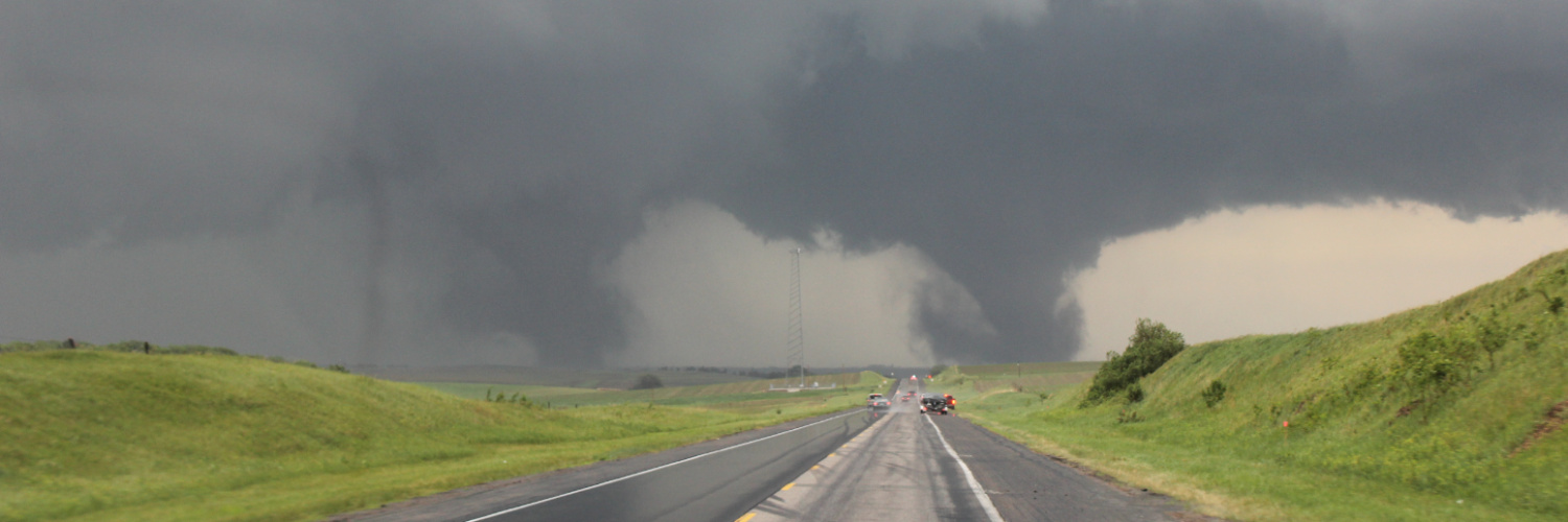
I got some crazy videos today - this was northwest of Watertown like 39 minutes ago, this tornado was mean - more soon
Very intense tornado has damaged structures W of Watertown SD
Incredible tornado to the west of Watertown @NWSAberdeen #sdwx
Tampa broke the all time high record reaching 100° today!! #FLwx
We are now at 99 in Tampa. That means we have tied the all time record high. Records started on April 1st 1890.

Spectacular mothership supercell west of Bow City, Alberta! 😱 8:07pm #abstorm @teamdomcanada