National Weather Service
@NWS
Official X account for @NOAA's National Weather Service. A list of official NWS accounts can be found at https://x.com/i/lists/72504214
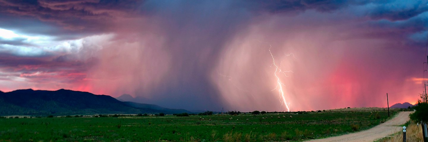
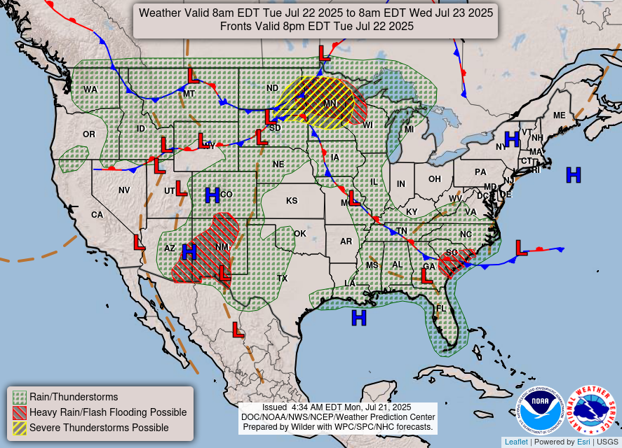
Heavy showers and thunderstorms will be developing and expanding in coverage going through the evening hours across portions eastern MO through southern IN. High rainfall rates and some cell-training concerns are expected to drive an increasing threat of flash flooding.
#WPC_MD 0768 affecting North-Central to Northeast MO...Central IL...Southern IN, #inwx #kywx #ilwx #mowx #iawx, wpc.ncep.noaa.gov/metwatch/metwa…
It's the height of summer, so it being hot in the southern U.S. is no surprise. BUT, when triple digits during the day barely drop to 80 overnight, it becomes extremely dangerous. Extreme and record heat is likely throughout the South through next week with extreme impacts…
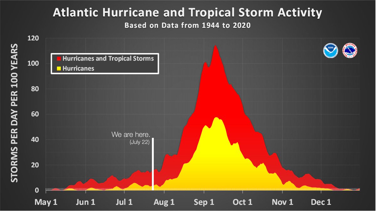
On average, 86% of all named tropical systems in the Atlantic occur after August 2, and the first hurricane doesn't form until August 11. We have a long season to go. Prepare now, and learn more about how at weather.gov/safety/hurrica…
Even the mysterious conditions of the cosmos can impact daily life on Earth, to great economic costs! Our @NWSSWPC monitors “space weather” impacts to our lives and infrastructure. The Sun’s high-speed energy bursts (e.g., solar flares and winds), can cause everything from…
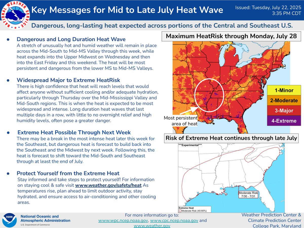
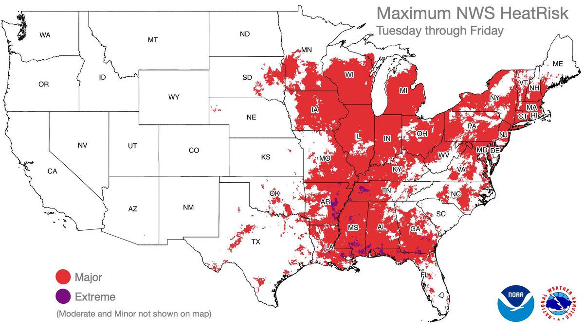
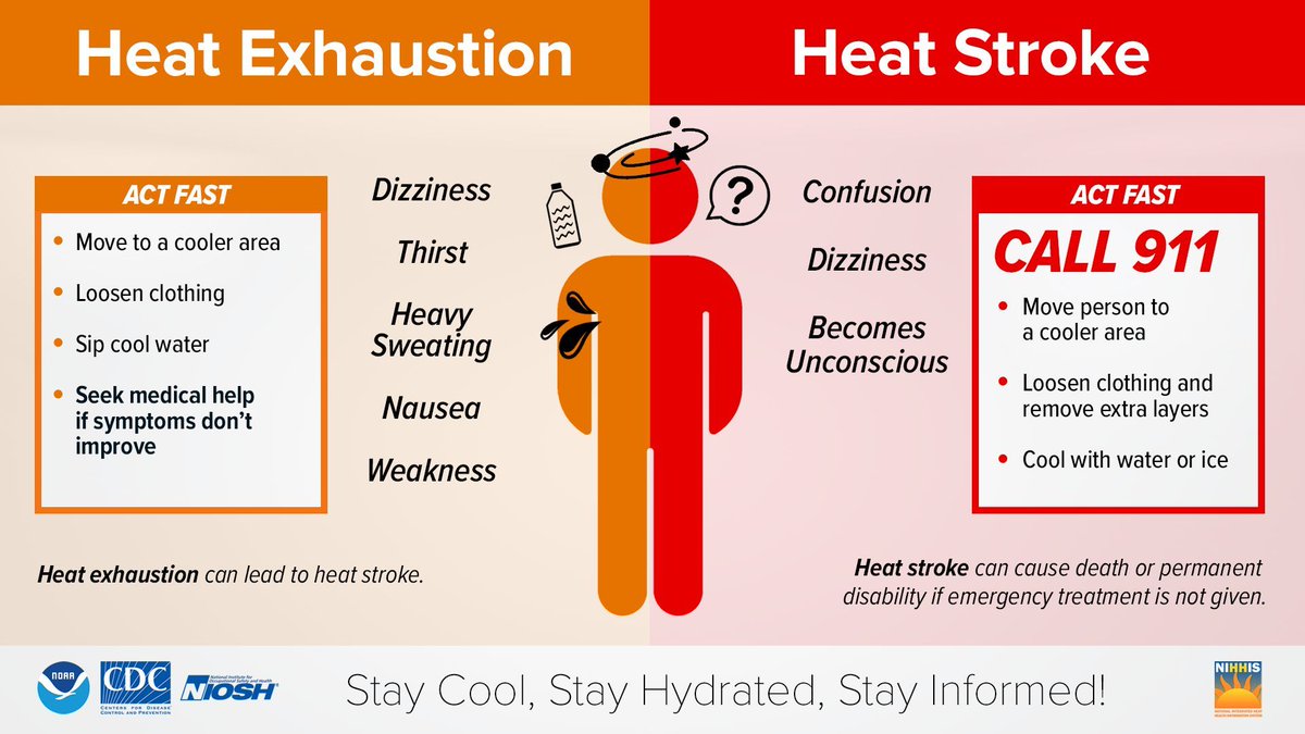
Dangerous, prolonged heat is expected across portions of the Central and Southeast U.S. through the end of July. Widespread Major to locally Extreme HeatRisk is expected, especially over the Mid-Mississippi, Lower Ohio Valleys, and the Mid South. During hot and humid weather,…
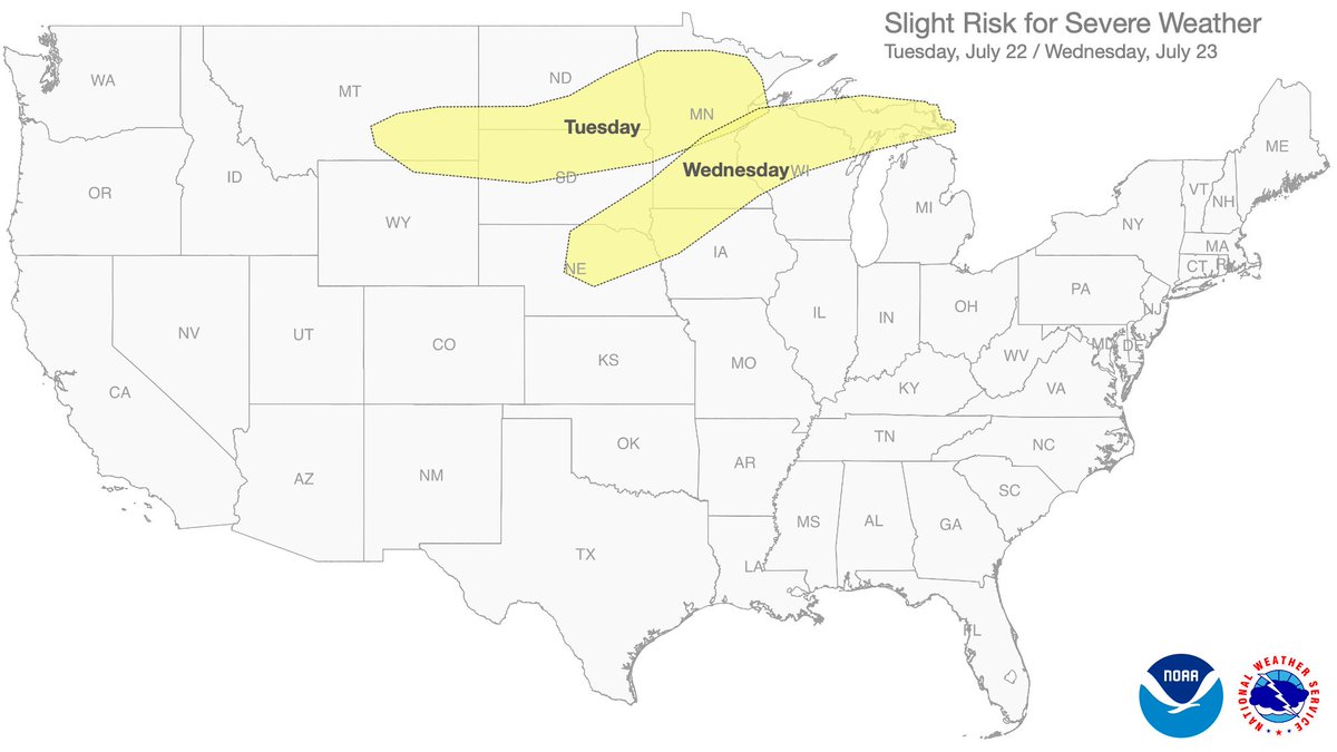
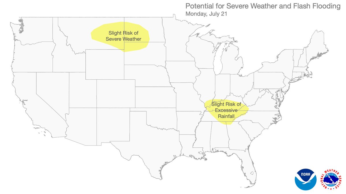
Severe weather outlook... Today (Tuesday): Scattered severe thunderstorms will be possible over parts of the northern Plains into the upper Mississippi Valley later today into tonight. Tomorrow (Wednesday): Organizing clusters of storms posing a risk for severe wind are…
.@NOAA’s first satellite fully dedicated to continuous, operational #SpaceWeather monitoring has arrived in Florida! The Space Weather Follow On - Lagrange 1 (#SWFOL1) 🛰️ will launch this fall and head to Lagrange point 1 (~1 million miles from Earth) where it will keep…
Scattered severe thunderstorms are expected over parts of the northern Plains into the upper Mississippi Valley Tuesday, with damaging winds and large hail as the primary threats. Heavy to excessive rainfall could lead to areas of flooding across the northern Plains, Upper…
Over 90 million people are under heat alerts currently (Extreme Heat Warnings, Watches, and Heat Advisories). The heat is expected to persist the longest over the Mid-MS Valley and Mid-South regions this week. Here are the latest Key Messages.
A Heat Advisory remains in effect today for the entire area. Afternoon heat index values are expected to rise to 105° to 110°F. - Drink plenty of water - Limit strenuous activities outdoors - Apply sunscreen every 2 hours - Watch for heat illness symptoms #okwx #texomawx
🌑 Celebrating a belated International Moon Day & the Apollo 11 Moon landing anniversary! On July 20, 1969, the “one giant leap for mankind” was made. Today, @NWSSWPC keeps spaceflight and Earth’s technology safe by tracking solar storms and other types of space weather events.…
.@NOAA's #GOESEast is tracking our weather this morning as #thunderstorms rumble around the nation. There is a #SlightRisk for #severe storms today across parts of eastern Montana. #Flood Watches also continue for much of the Ohio and Mid-Mississippi valleys. GOES19 Latest…
Today, on the periphery of heat building in the central and southern U.S. is the threat for severe thunderstorms across the northern Plains and heavy rainfall for portions of the Ohio and Tennessee River Valleys. Visit weather.gov for your local forecast.
Additional rounds of heavy showers and thunderstorms coupled with locally high rainfall rates and some cell-training concerns will likely promote some additional areas of flash flooding this evening across portions of Kentucky, southern West Virginia and Virginia.
#WPC_MD 0769 affecting Northern and Eastern KY...Southwest VA...Southern WV, #wvwx #vawx #ncwx #tnwx #kywx #ohwx #inwx, wpc.ncep.noaa.gov/metwatch/metwa…
6:12pm CDT #SPC_Watch WW 533 SEVERE TSTM IL IN 202310Z - 210500Z, #ilwx #inwx, spc.noaa.gov/products/watch…
A tornado watch has been issued for parts of Nebraska and South Dakota until 11 PM CDT
A severe thunderstorm watch has been issued for parts of Montana and North Dakota until 12 AM MDT
Flash flooding is anticipated tonight over Northeast MO and Central IL as storms containing 3-4"/hour rainfall rates develop this evening. Numerous flash floods are likely in the Moderate Risk area, some of which could be significant with localized 8" rainfall amounts possible.
A severe thunderstorm watch has been issued for parts of Connecticut, Maine, Massachusetts, New Hampshire, Rhode Island and Vermont until 9 PM EDT