Nelson Tucker
@TornadoStudy
President of @project_otus. Researcher, writer, admin at @tornado_talk. Millersville Meteorology 2026. NIST SURF 2024. Storm Chaser, Skywarn Spotter, CERT.
We flew through and stayed in the centers of two tornadoes today, triple intercepts! Most remarkable experience of my life chasing these tornadoes
The eye of the Arnett, OK tornado, captured by one of our UAVs as it collected scientific data on the environment within.
Saw a multi-vortex tornado this afternoon at Parmelee SD, had an @project_otus deployment on this


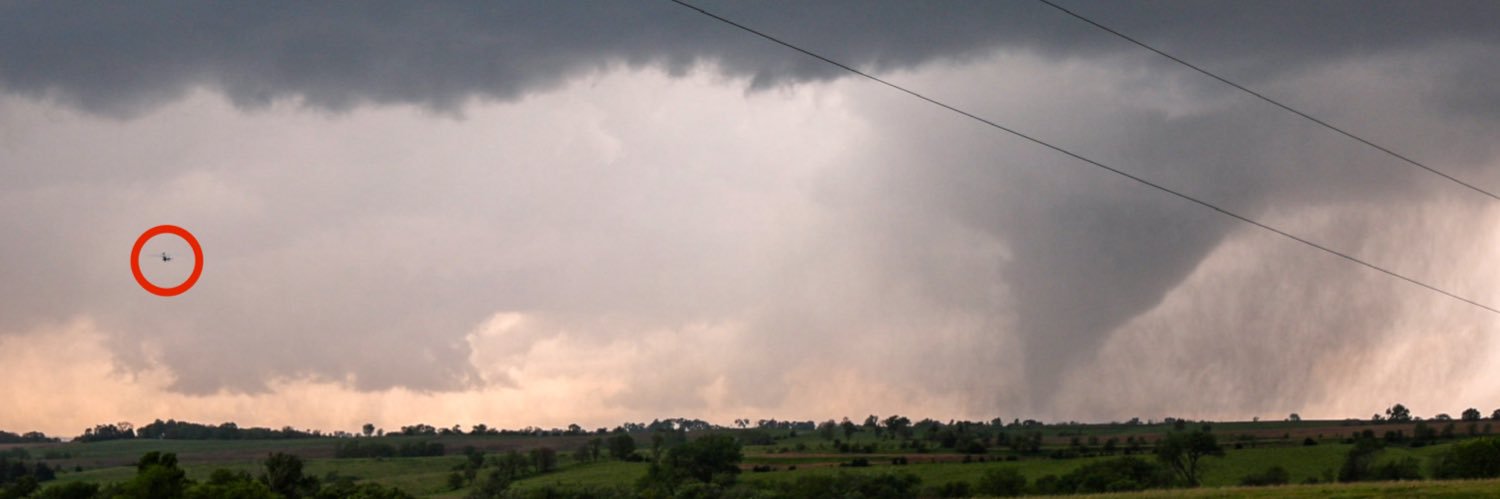
Narrowly missed getting a drone inside this tornado south of Johnstown/Ainsworth, NE yesterday evening. We will be on the hunt for the next few days. Photo taken by team member @TornadoStudy
Massive flooding going on right now In Ruidoso, New Mexico #nmwx #ruidoso This video from Kaitlyn Carpenter on FB. #flooding #NewMexico
The Rio Ruidoso river gauge in Hollywood, NM went from a base level of 1.4 ft to 20.24 ft in 30 minutes. Catastrophic flooding in a very short time. Rain fell across the higher terrain to the west roughly 1-2 hours before the wall of water made its way downstream to the gauge.…
ABSOLUTELY, @averytomascowx .. @NWSSanAntonio did a good job with the issuance of watches and warnings for the Kerrville disaster! Yep.. forecast rainfall totals were lower at first but they adjusted. The @NWS is not to blame here.. period!!
All I'll say is this. The National Weather Service issued a flood watch for Kerr County more than 12 hours ahead of the catastrophic flood. A flash flood warning was issued for Hunt & Ingram 3 HOURS before the Guadalupe started to climb. They did their job and they did it well
This gut wrenching tragedy in the Texas Hill Country is so painful for so many reasons The frustration is that the state emergency ops people were actually prepared and were issuing warnings on Thursday before lunch. This is what they sent out Thurs assuring they were ready
Flash Flood Emergency including Lago Vista TX, Jonestown TX and Briarcliff TX until 5:00 AM CDT
The surge of floodwater has passed the USGS river gauge along the Guadalupe River near Bergheim, TX, NW of San Antonio. The river went from just over 5 feet to more than 49 feet in five hours. 44 FOOT WATER RISE. @troykimmelwx
Weather balloons are critical information, and this is why so many of us continue to scream from the rooftops about cutting data and research from NOAA.
Post shared elsewhere from a WPC forecaster who was working last night demonstrating the value of weather balloon data to short-term forecasting of hazards including flash flooding and severe weather.
Here is TIME-LAPSE video of the rapid flooding of the Guadalupe River in Kerrville. This video shows the gazebo going underwater and has likely been swept away by the floodwaters. bit.ly/44vNYop
About 23 girls at Camp Mystic remained unaccounted for Friday after deadly flooding from the Guadalupe River caused “destructive” floods at the private Christian summer camp in Hunt, Texas, Lt. Gov. Dan Patrick said. houstonchronicle.com/news/houston-w…
Catastrophic floodwave continues to move down the Guadelupe River toward Spring Branch. Horrific flooding along the river from Hunt downstream has resulted in many fatalities and many more missing. Those searching for missing can call 800-733-2767 #txwx
Just. Wow. As we went over Mexico and the U.S. this morning, I caught this sprite. Sprites are TLEs or Transient Luminous Events, that happen above the clouds and are triggered by intense electrical activity in the thunderstorms below. We have a great view above the clouds, so…
A peek at preliminary tornado data we are still processing. These traces are from one of the drones circling in the anticyclonic Higgins, TX-OK EF1 on May 18. The validation and quality control process takes time, but more data will be shared as we progress.
NSSL, GFDL, all of the Cooperative Institutes (including where I work), AOML (including the Hurricane Research Division which goes on Hurricane Hunters flights and develops hurricane research models), all gone. Warn on Forecast, PAR, VORTEX, all dead in the water. this is grim
There's a lot of bad news in the NOAA budget release, and yes there are going to be negotiations over the next few months. But what's baffling to me is the complete elimination of the OAR labs, especially NSSL. Like, no one in Oklahoma is going to stop that from happening?
Destroying the research that makes us better at forecasting. You can't ask us to play piano if you cut off our hands.
There's a lot of bad news in the NOAA budget release, and yes there are going to be negotiations over the next few months. But what's baffling to me is the complete elimination of the OAR labs, especially NSSL. Like, no one in Oklahoma is going to stop that from happening?
Gonna save the rest of my footage for the YT video that won’t be out for 8 months but just gonna leave this clip here because I can not believe a tornado can move like this…
Not surprised to get the Baghdad Bob statement from the official spokesperson, but the ATMS microwave satellite is way too low resolution for most hurricane applications. Often the entire core is a couple pixels and you can't distinguish eye from eyewall or anything useful like…
I sought comment from @NOAA and @DeptofDefense on this and received a reply today from NOAA's spokesperson. They suggest we use the surviving ATMS microwave that degrades significantly at the edges. You can see how much worse off we'd be with Erick last week if we only had ATMS.