FEMA Region 7
@femaregion7
FEMA Region 7 - Features FEMA mission-related info. For emergencies, call local fire/EMS/police or 9-1-1. Serving IA, KS, MO, NE. #preplist, #MidwestReady
❗️Deadline! If you were impacted by March 14-15 storms & live in 1 of 18 #MO counties, July 22 is your last chance to register for @FEMA help w/uninsured losses. 🔹Online at disasterassistance.gov 🔹Call 1-800-621-3362 (FEMA) More info: fema.gov/disaster/4867 #mowx @StlCoOEM

Flash Flood Warning including Des Moines IA, West Des Moines IA and Altoona IA until 10:00 PM CDT
🏚️Impacted by recent #MO disasters? If you don't have a safe place to live, you can apply for @FEMA assistance to help pay for temporary, alternate housing. Learn more: fema.gov/press-release/… #mowx #stlwx @ulstl @StlCoOEM

‼️URGENT. Weather pros have identified tornado activity moving east from Des Moines at approx. 2:30 p.m. 7/11. Ber #WeatherAware!! #iawx #mowx #ilwx
Tornado Warning including Newton IA and Lambs Grove IA until 3:15 PM CDT
📱Stay alert for weather conditions today/tonight (7/11). Expected impacts in #IA #KS #MO #NE include heavy rain, high winds, hail & possible tornadoes. Make sure to #BeReady day & night! #iawx #kswx #mowx #newx @IowaHSEM @IowaEMA @NEMATweets @MOSEMA_
A tornado watch has been issued for parts of Illinois, Iowa and Missouri until 8 PM CDT
The deadline to request Public Assistance is TOMORROW, July 9, for local governments & qualifying nonprofits for the repair of damaged roads, bridges, & other public infrastructure as well as reimbursement of associated emergency response & recovery costs: sema.dps.mo.gov/programs/state…
❗️#NE #KS! Heads up today as all severe weather hazards are possible. Know how to react & have multiple ways to get alerts! Take warnings seriously. Please. #newx #kswx #mowx #iawx #MO #IA @Omaha_wx #sdwx
Enhanced Risk 3/5 remains in place across portions of the central and northern Plains. Damaging wind gusts hail and isolated tornadoes possible. Severe storms are expected early afternoon into this evening. See spc.noaa.gov and your local NWS office for more info.
The Disaster Recovery Centers in St. Louis will be closed on Friday, July 4, for the holiday. All centers will reopen Saturday, July 5, at 8 a.m. to help with applications for FEMA and SBA. The Union Tabernacle DRC will be closed from July 6 to 13 and reopen on July 14.
Damaging winds to 65 mph and locally heavy rainfall leading to a localized flooding risk will also occur with these storms this afternoon into early evening.
⛈️Heavy rain & T-storms have been moving thru the Midwest today. Areas in #IA #KS #MO #NE are on tap for more heavy rain & storms tonight (6/29) into early a.m. Stay on top of forecasts & do NOT drive thru floodwaters. #BeReady. #iawx #kswx #mowx #newx

☔️Rain, rain go away. It won't be tonight. Or tomorrow. #NE #IA #KS: Pay close attention! Flooding & severe storms occurring tonight. More tomorrow, incl. heavy rain. #BeReady & stay #WeatherAware. #iawx #newx #kswx #mowx @IowaEMA

‼️Buckle up #KS #MO #NE #IA. Rocky weather expected today (5/17) incl. heavy rain, ⬆️ wind, possible tornadoes. Keep up w/forecasts, #BeReady for changing severity & have multiple ways to get alerts. Safety is YOUR priority today/tonight. @trooperbenKHP #kswx #mowx #newx #iawx

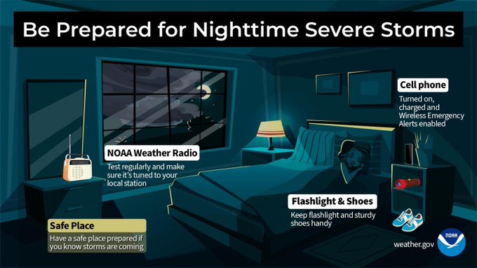
‼️#NE & #KS. See updated info from @NWSTopeka for storms overnight (6/16-17). #Prep before you go to bed so you can take action if needed overnight. Have multiple ways to get alerts & make sure at least one of them will wake you up! #newx #kswx @NEMATweets @kansasemergency
Thunderstorms forming a complex over southern NE are expected to move south and into parts of NC KS between midnight and 2am. They may have wind gusts around 60 mph and heavy rain. Storms are still forecast to weaken with time. #kswx
‼️ Severe weather moving across #KS #NE & into #IA tonight (5/16). Multiple watches/warnings being issued. 🌪️Tornadoes warned in KS & NE moving east. Follow weather pros + local @NWS offices in your state for updates. Take seriously & #BeReady. #newx #kswx #iawx #mowx

✳️ #Missouri. Your disaster recovery is underway! @FEMA may be able to help. Contact us today to start your process & learn next steps! #mowx #stl #stlwx

You might be on vacation, but today's weather isn't! T-storms expected (Sun 6/15) for #IA #KS #MO #NE. Some areas at ⬆️risk. Be prepared for ALL hazards, even if not predicted. Weather this spring has been rough. Have a plan & #BeReady to act! #mowx #spgwx #newx #kswx #iawx

📌@FEMA leadership & @SBA reps joined St. Louis Mayor Cara Spencer on 5/11 to update disaster recovery efforts from May 16 severe storms & tornadoes, including how storm-impacted Missourians can apply for FEMA at disasterassistance.gov or 1-800-621-3362 (FEMA). #mowx #stlwx

❗️Know Before You Go! If you're planning to be outside today (Sun. 6/8), follow forecasts & #BeReady to adjust if severe weather comes your way, especially #KS, #MO. 🪨Hail hurts! 🪨 So if it finds you, get out of the way & into a sturdy shelter. #mowx #spgwx #kswx #midmowx


☀️Impacted by March 14-15 severe storms in MO? You can visit a @FEMA Disaster Recovery Center for help. You could be eligible for FEMA if you are a storm survivor in 1 of 18 disaster-designated #MO counties. See the list here: fema.gov/disaster/4867. #mowx #midmowx @FCEMHS

🌪️SW #KS! Tornado Watch Today (Thurs. 6/5) until 9 p.m. CDT. Large hail possible. 🔸Monitor forecasts 🔸Make a plan 🔸I.D. a safe place to shelter 🔸Take warnings seriously 🔸#BeReady to act! #kswx

