NOAA Satellites
@NOAASatellites
The NOAA Satellite & Information Service (referred to as NESDIS) is a line office of @NOAA.
Air travel fuels ~$400B of U.S. GDP, but space weather like solar flares & winds can disrupt navigation, comms, & passenger safety. @NWSSWPC tracks the Sun’s activity and provides warnings and predictions in real-time, helping the United States’ 700,000 pilots make the most…
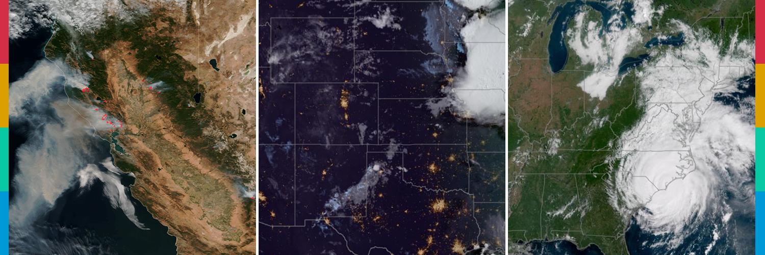
.@NOAA's #GOESEast 🛰️ is tracking the #wildfire #smoke as it drifts across the Upper Midwest today. Along with hazy skies, #AirQuality is expected to reach the Unhealthy category in some locations. #GOES19
Air quality alert due to wildfire smoke expanded to include northern, central, south central, and southwest Minnesota through Friday, July 25
The Dragon Bravo Fire in the North Rim of Grand Canyon National Park is emitting a large, thick smoke plume (red shading) today 23 Jul, shown by aerosol optical depth from the ABI sensor on @NOAASatellites GOES-West. @GrandCanyonNPS
The large #CramFire continues to burn north of Prineville, Ore., this week and the #NOAA21 satellite has been tracking it from orbit. In this imagery from July 13-22, you can see the smoke and burn scar as the #wildfire has grown to more than 95,000 acres.
As @NOAA's #GOESEast 🛰️monitors the nation's weather this morning, there is a #SlightRisk for #severe #thunderstorms producing damaging wind gusts and #tornadoes across the Northern Plains and western Great Lakes this afternoon. Some places under the threat for severe weather…
Hypnotic von Kármán vortices cascade off of Guadalupe Island, swirling over the eastern Pacific Ocean.
Visible imagery from @NOAA's @GOESEast 🛰️ helped track the bubbling #severe thunderstorms that pushed across Kansas yesterday evening. Some storms dropped golf ball-sized #hail and brought hurricane-strength wind gusts. #GOES19 See where more severe storms may fire up today:…
Even the mysterious conditions of the cosmos can impact daily life on Earth, to great economic costs! Our @NWSSWPC monitors “space weather” impacts to our lives and infrastructure. The Sun’s high-speed energy bursts (e.g., solar flares and winds), can cause everything from…
.@NOAA’s first satellite fully dedicated to continuous, operational #SpaceWeather monitoring has arrived in Florida! The Space Weather Follow On - Lagrange 1 (#SWFOL1) 🛰️ will launch this fall and head to Lagrange point 1 (~1 million miles from Earth) where it will keep…

🌑 Celebrating a belated International Moon Day & the Apollo 11 Moon landing anniversary! On July 20, 1969, the “one giant leap for mankind” was made. Today, @NWSSWPC keeps spaceflight and Earth’s technology safe by tracking solar storms and other types of space weather events.…
Another intrusion of Canadian wildfire smoke is degrading PM2.5 air quality this morning 21 Jul in the Great Lakes & Northeast US. Smoke is moving in behind a cold front. 1-hour average PM2.5 is as high as 50-60 ug/m3 in southern WI & northern IL (orange dots). @NOAASatellites
.@NOAA's #GOESEast is tracking our weather this morning as #thunderstorms rumble around the nation. There is a #SlightRisk for #severe storms today across parts of eastern Montana. #Flood Watches also continue for much of the Ohio and Mid-Mississippi valleys. GOES19 Latest…
It’s #FullDiskFriday! From its place in space, @NOAA's #GOESEast 🛰️ monitors Earth's water vapor as it moves across our dynamic planet. In this imagery, drier air is depicted as orange and yellow, moister air is blue and white, and cloud cover is shades of green. #GOES19
As @NOAA's #GOESEast monitors the nation's weather this morning, there is a #SlightRisk for #severe #thunderstorms across parts of the Central Plains and Mid-Atlantic today. #Flood Watches continue for much of the central Appalachians, Virginia and southern Louisiana. More:…
.@NOAA’s Center for Satellite Applications and Research (STAR) at NESDIS helps keep the nation prepared for #hurricane season with vital satellite data and tools that support critical decisions–even after the storm has passed. Learn more about STAR’s contributions by reading the…
