AerosolWatch
@AerosolWatch
Global aerosols & air quality information, featuring NOAA satellite products from the AerosolWatch website
Total column carbon monoxide (CO) from the @tropomi sensor on the Sentinel 5-P satellite shows the tremendous emissions from ongoing Canadian wildfires, wrapping around a large Low pressure system yesterday 23 Jul. @CopernicusEMS

The Dragon Bravo Fire in the North Rim of Grand Canyon National Park is emitting a large, thick smoke plume (red shading) today 23 Jul, shown by aerosol optical depth from the ABI sensor on @NOAASatellites GOES-West. @GrandCanyonNPS

Thick smoke is moving over the Canadian Maritimes this morning 23 Jul, highlighted by aerosol optical depth from the ABI sensor on @NOAASatellites GOES-East. The smoke originated from wildfires in central/western Canada. It is aloft, not affecting surface air quality.
Another intrusion of Canadian wildfire smoke is degrading PM2.5 air quality this morning 21 Jul in the Great Lakes & Northeast US. Smoke is moving in behind a cold front. 1-hour average PM2.5 is as high as 50-60 ug/m3 in southern WI & northern IL (orange dots). @NOAASatellites

Aerosol detection smoke mask from VIIRS on the @JPSSProgram satellites highlights smoke (purple/magenta shading) across Canada on 17 Jul from the ongoing wildfires in the central and western regions of the country. @NOAASatellites

To our data users: Near real-time imagery stopped early this morning 17 Jul on the AerosolWatch website star.nesdis.noaa.gov/smcd/spb/aq/Ae…. We are working to return the site to normal operation as soon as possible.
Aerosol optical depth from the VIIRS sensor on @JPSSProgram NOAA-20 observed moderate to thick smoke from several wildfires in the Pacific Northwest on 16 Jul, including the Cram Fire in Oregon & the Green Fire in northern California. @NOAASatellites

Lingering transported wildfire smoke pushed daily PM2.5 air quality to the Code Orange (USG) to Yellow (Moderate) range along the eastern US-Canada border on 15 Jul, per estimates from @JPSSProgram satellites (shading) & observed by regulatory monitors (dots). @NOAASatellites

Transported smoke from wildfires in western/central Canada caused poor PM2.5 air quality across the Great Lakes region of the US & Canada yesterday 14 Jul, estimated from @JPSSProgram satellites (shading) & observed by @AIRNow regulatory monitors (dots). @NOAASatellites

VIIRS on @JPSSProgram NOAA-20 observed the devastating Dragon Bravo Fire in Grand Canyon National Park emitting thick grey smoke on 13 Jul. Fire Radiative Power (red/orange dots) shows the location & intensity of active burning. @NOAASatellites @GrandCanyonNPS

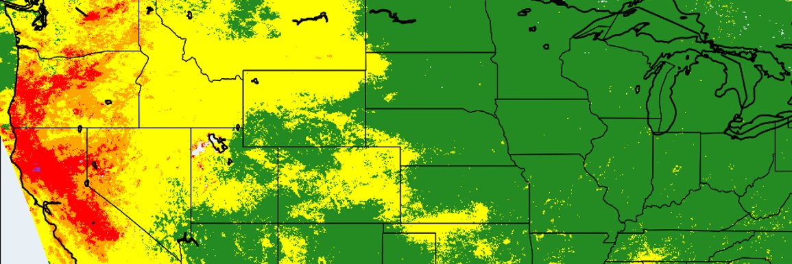
Daily PM2.5 air quality on 13 Jul was degraded in the US Upper Midwest & south-central Canada by smoke from Canadian wildfires, and locally by smoke from wildfires in northern California, estimated from @JPSSProgram VIIRS (shading) & observed by @AIRNow monitors (dots).

The latest intrusion of smoke from Canadian wildfires continues to push east & south this morning 14 Jul, bringing poor PM2.5 air quality to MN, WI, MI, ON & QC (red/yellow/orange dots), shown by ABI GeoColor from @NOAASatellites GOES-East & @AIRNow surface monitors.
Thick smoke (orange/yellow/teal shading) is streaming southward from the Green Fire and Orleans Complex wildfires in northern California today 11 Jul, shown by aerosol optical depth (AOD) from the ABI sensor on @NOAASatellites GOES-West. @CAL_FIRE
Wildfires in northern California & southern Oregon yesterday 9 Jul emitted localized smoke plumes that degraded daily PM2.5 air quality (purple, red & orange shading) in between sites of regulatory PM2.5 monitors (colored dots). @JPSSProgram @NOAASatellites @AIRNow

This morning 10 Jul, a wildfire or controlled burn (yellow marker) in Florida south of Lake Okeechobee is emitting a moderately thick smoke plume (light blue/teal shading), blowing initially northward & then southwestward over the Gulf, per ABI on @NOAASatellites GOES-East.

The ABI sensor on @NOAASatellites GOES-East observed a large plume of Saharan dust (yellow shading) moving westward over the tropical Atlantic Ocean yesterday 8 Jul. @DustStormNews
The VIIRS sensor on @JPSSProgram NOAA-21 observed thick smoke (purple shading) from ongoing seasonal wildfires in Alaska yesterday 7 Jul, which caused Unhealthy (Code Red) daily PM2.5 air quality in Fairbanks. @NOAASatellites @UAFGI @uafairbanks @Karma_lobsang12

To our data users: Data from the @JPSSProgram SNPP satellite has been missing over most of the Western Hemisphere since 4 Jul. This is due to a network issue at the Fairbanks, AK (FBK) receiving station. The outage duration is TBD. For more info: ospo.noaa.gov/data/messages/…