MNStorm
@mn_storm
Severe/fire weather enthusiast. Meteorology student at SCSU.
OTD in 2024, a high-intensity wildfire raced through Jasper National Park. The fire generated at least four tornadic vortices all of which were likely significant. This was, in my opinion, one of the more impressive fire tornadic events on record. #abstorm #abfire

11:51pm CDT #SPC Day1 #FireWX Critical: portions of northern california spc.noaa.gov/products/fire_…
Featured in @TorontoStar: A year later, researchers from #WesternU's Northern Tornadoes Project suspect fire-induced tornadoes could be to blame for some of the damage caused during wildfires in Jasper last July. brnw.ch/21wUmB2
Numerous wildfires are burning across the eastern Mediterranean today.

#Πυρκαγιά #Κορινθία Ανεξέλεγκτη η πυρκαγιά. Ενισχύθηκαν οι δυνάμεις στη δασική πυρκαγιά στη Δ.Ε. Φενέου Κορινθίας και επιχειρούν 185 πυροσβέστες με 6 ομάδες πεζοπόρων της 1ης, 6ης και 9ης ΕΜΟΔΕ, 5 οχήματα, και ομάδα Σ.μη.Ε.Α. ενώ έχουν διατεθεί 15 Α/Φ και 11 Ε/Π αεροπυρόσβεσης.
🇹🇷🔥 A low-level Fire-Generated Vortex (FGV) was observed on 21 July 2025 during an intense and fast-moving wildfire near Bilecik, northwestern #Turkey. Preliminary visual evidence points to strong fire-atmosphere coupling. @nplareau would love to hear your perspective on that
Both EPS and GEFS are showing a pretty good chance of a strong ridge building over the central or western US at the end of July. If it builds further west it could escalate the fire season. #cawx #wildfires


Information on the fire-induced tornado at the Deer Creek Wildfire in Utah 7/12/2025. #utwx weather.gov/gjt/12July2025…
Looks like the #DeerCreekFire got an EF2 rating which would make it the first fire tornado to receive a significant rating since 2020. #utwx


Here is the radar analysis of the #DeerCreekFire's plume at the time of the tornadic vortex. These data show a rapidly deepening plume at the time of the peak vortex strength (~1310 MDT), followed by overshooting convection that penetrates the tropopause, reaching ~40,000 ft.…
This footage shows the size, scale, and severity of the Fire weather event that took place on the Deer Creek Fire in La Sal, Utah. One individual said they believed a skid plate off a Toyota Tacoma was hurled and hit their fire apparatus. The shear size and velocity of this…
[Delayed Report] On Jul 12, at 1:03 PM MDT, 4 NNE La Sal [San Juan Co, UT] Other Federal reports Tornado. Fire induced tornado at the Deer Creek wildfire. #utwx mesonet.agron.iastate.edu/lsr/?by=wfo&wf…
The #MonroeCanyonFire is already quite active this morning with 20-21 kft plume tops. #utwx #utfire
This footage shows the size, scale, and severity of the Fire weather event that took place on the Deer Creek Fire in La Sal, Utah. One individual said they believed a skid plate off a Toyota Tacoma was hurled and hit their fire apparatus. The shear size and velocity of this…
A lot of flow splitting around the head/flanks of the #MonroeCanyonFire

inciweb.wildfire.gov/incident-video… More incredible footage of the tornadic vortex that occurred a few days ago on the #DeerCreekFire. #cowx
Pyrocumulus cloud from the #PlacerCreekWildfire near Eastgate (Manning Park) just west of Princeton BV visible all the way in the Fraser Valley. H/T 📸: IngallsWX #BCwx #BCstorm #BCwildfire #BCfire #Pyrocumulus #BCdry #BCheat
🔥 FIRENADO 🌪️ #DeerCreekFire - San Juan County, Utah An EXTREMELY large fire whirl was observed by firefighters on Saturday, July 12 in the early afternoon being called a “vortex/tornado ordeal” by fire managers. Debris can be seen flying through the air as the ‘firenado’…
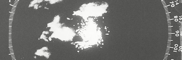
Looking at KGJX, the tight rotational couplet associated with this tornadic vortex was clearly visible. The depth of the vortex was up to ~6000 feet. #cowx #cofire
Utah: This is probably the craziest “Firenado” I’ve ever seen. This off the Deer Creek Fire today, near La Sal, which saw very extreme fire behavior leading to crews pulling back to safety zones and further evacuations. The fire was last mapped at 8,300 acres, but has since…
Utah: This is probably the craziest “Firenado” I’ve ever seen. This off the Deer Creek Fire today, near La Sal, which saw very extreme fire behavior leading to crews pulling back to safety zones and further evacuations. The fire was last mapped at 8,300 acres, but has since…
Two @NOAASatellites #NOAA21 #VIIRS GeoColor images (with an overlay of Fire Radiative Power) at 1755 UTC & 1943 UTC on July 10 showed a large wildfire in western Ontario that produced a #pyrocumulonimbus cloud - more on the CIMSS Satellite Blog: cimss.ssec.wisc.edu/satellite-blog…