NWS Grand Junction
@NWSGJT
Official X account for the National Weather Service Grand Junction. Details: http://weather.gov/nws_x
Gusty winds of 25 to 35 mph and relative humidities in the single digits will bring critical fire weather conditions back to much of the region today. Red Flag Warnings are in effect from noon until 8 PM tonight as a result. #COwx #UTwx

Conditions dry out and temps warm up throughout the weekend and into Monday. With breezy winds expected this weekend, critical fire weather conditions are likely, particularly on Saturday. Fire Weather Watch has been issued for Saturday for much of the area. #COwx #UTwx

High elevation showers and storms continue to be a threat today with gusty winds and lightning the main concerns with wetting rain chances less likely west of the Divide. Hot, dry and windy conditions return this weekend with potential for critical fire weather. #COwx #UTwx

Afternoon showers and storms will favor high terrain today and Thursday. Frequent lightning and strong outflow winds are possible with small hail in the stronger storms. Hotter, drier weather and the potential for fire weather concerns return Friday into the weekend. #COwx #UTwx

Isolated showers linger this morning with the highest chances of storms over the San Juans and central Colorado divide this afternoon. Gusty winds and wetting rain with light precipitation amounts expected with storms. #COwx #UTwx

Temps will run near normal to a little below normal for the first half of the week, warming to a little above normal by Saturday. Afternoon thunderstorms in the mountains will continue through Thursday before the weather dries out. #COwx #UTwx

Isolated to widely scattered showers and thunderstorms will continue over the higher terrain today, while the valleys remain mostly dry. Temperatures will run near to slightly above normal the next few days. Shower and thunderstorm coverage will increase tomorrow. #cowx #utwx

Afternoon shower and thunderstorm will be even more limited today, thanks to a bit of drier air working into the area. This will keep things confined to the higher terrain, with the San Juans the most favored to see afternoon showers and thunderstorms. #COwx #UTwx

Isolated to scattered thunderstorms today, primarily across the higher terrain. Gusty winds and frequent lightning will be the primary concerns with these storms. Look for temperatures to warm up a bit today and tomorrow as well. #COwx #UTwx

A special weather statement has been issued for Ballard UT, Fort Duchesne UT and Randlett UT until 4:45 PM MDT

Expect widespread showers and thunderstorms today, with the higher terrain seeing the highest chances. Some storms may produce large hail. damaging winds and heavy rain. Flash flooding is possible in susceptible areas, such as fire scars and slot canyons. #COwx #UTwx

An increase in moisture over southwestern Colorado will boost chances for showers and thunderstorms today, primarily across the San Juans. Strong outflow winds are again possible, and localized flooding concerns may occur with stronger storms. #COwx #UTwx

A special weather statement has been issued for Rio Blanco County, CO until 6:15 PM MDT

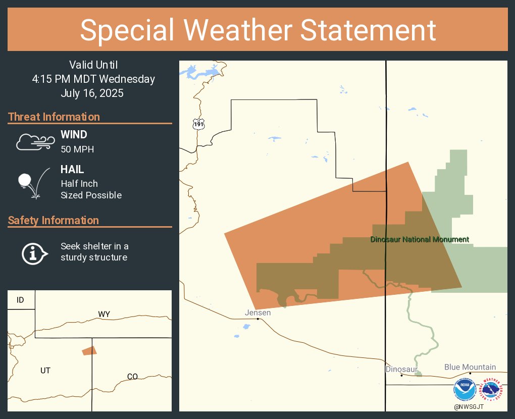
A special weather statement has been issued for Uintah County, UT until 4:15 PM MDT
A special weather statement has been issued for Maeser UT and Whiterocks UT until 3:15 PM MDT

Aviso de Tormenta Severa continúa Uintah County, UT hasta la 1:00 PM MDT

Severe Thunderstorm Warning continues for Daggett County, UT, Uintah County, UT until 1:00 PM MDT

Aviso de Tormenta Severa incluye Uintah County, UT hasta la 1:00 PM MDT

Severe Thunderstorm Warning including Daggett County, UT, Uintah County, UT until 1:00 PM MDT

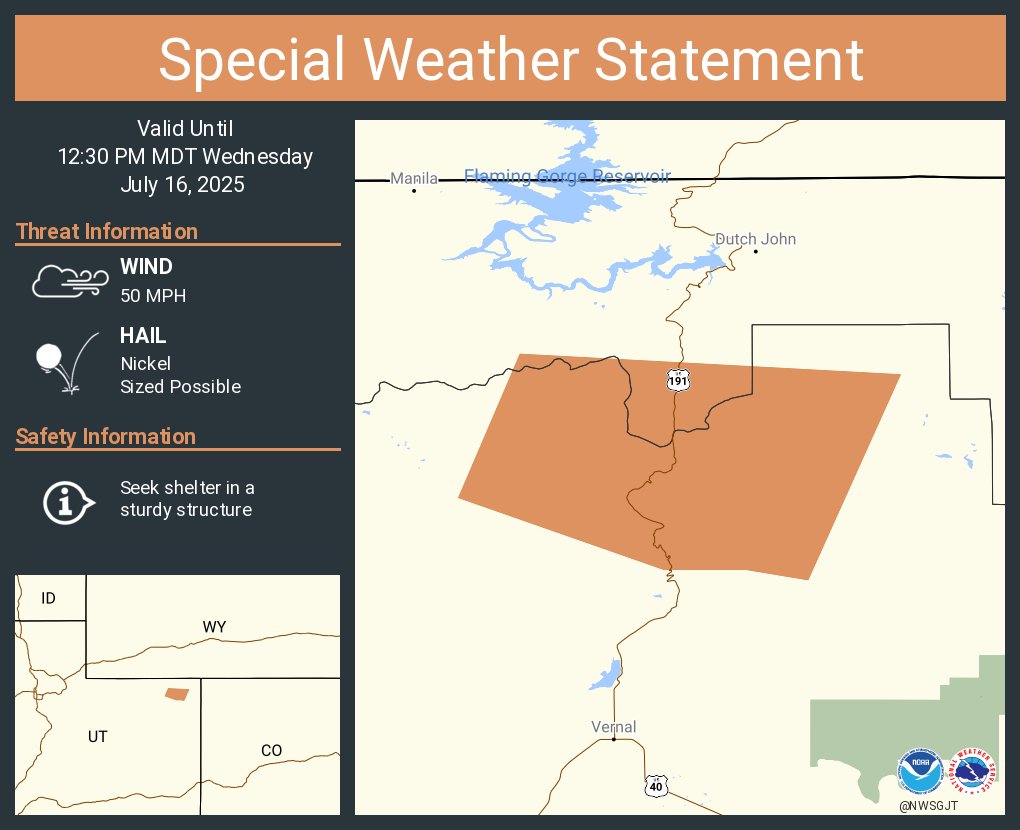
A special weather statement has been issued for Uintah County, UT until 12:30 PM MDT