
Scott Bachmeier
@CIMSS_Satellite
Satellite meteorologist. NOAA Cooperative Institute for Meteorological Satellite Studies, UW-Madison. Personal account. http://wisc-satellite.bsky.social
1-minute #GOES18/#GOESWest Infrared (with the Fire Mask derived product) and Visible images showed that the #MonroeCanyonFire in Utah produced 2 #pyrocumulonimbus clouds (shades of blue in the Infrared images) late in the day on 25 July. @NWSSaltLakeCity #UTwx h/t @mn_storm
5-minute @NOAASatellites #GOES18/#GOESWest True Color+Nighttime Microphysics RGB images showed a Mesoscale Convective Vortex (MCV) that was migrating W-NW from southern AZ to southeast CA during the 16-18 July period. More on the CIMSS Satellite Blog: cimss.ssec.wisc.edu/satellite-blog…
Two @NOAASatellites #NOAA21 #VIIRS GeoColor images (with an overlay of Fire Radiative Power) at 1755 UTC & 1943 UTC on July 10 showed a large wildfire in western Ontario that produced a #pyrocumulonimbus cloud - more on the CIMSS Satellite Blog: cimss.ssec.wisc.edu/satellite-blog…
10-minute @NOAASatellites #GOES19/#GOESEast Infrared images (along with the Fire Mask product) showed that a wildfire in western Ontario produced a large #pyrocumulonimbus cloud on July 10 -- more on the CIMSS Satellite Blog: cimss.ssec.wisc.edu/satellite-blog… h/t @mn_storm
5-minute @NOAASatellites #GOES19/#GOESEast Infrared images showed the thunderstorms that produced heavy rainfall which led to deadly flash flooding in Ruidoso, New Mexico on 08 July - more on the CIMSS Satellite Blog: cimss.ssec.wisc.edu/satellite-blog… @NWSAlbuquerque #NMwx
5-min @NOAASatellites #GOESEast Infrared images showed the initial period when t-storms produced very heavy rainfall across the Texas Hill Country - producing catastrophic flash flooding resulting in > 80 fatalities. More on the CIMSS Satellite Blog: cimss.ssec.wisc.edu/satellite-blog… #TXwx
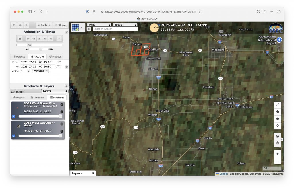
ICYMI, the thermal signature and smoke plume from an explosion at a fireworks facility in Esparto, California on July 1 were captured by imagery from @NOAASatellites #GOES18/#GOESWest and #GOES19/#GOESEast: cimss.ssec.wisc.edu/satellite-blog… @NWSSacramento #CAwx
This past Saturday, a wildfire in the Northwest Territories of Canada produced a large #pyrocumulonimbus cloud -- more on the CIMSS Satellite Blog: cimss.ssec.wisc.edu/satellite-blog… H/T @mn_storm
1-minute Mesoscale Sector @NOAASatellites #GOES19/#GOESEast Visible images began to reveal the partially-exposed low level circulation center of Tropical Storm #Barry in the far southwestern Gulf of Mexico.
1-minute @NOAASatellites #GOES19/#GOESEast Infrared and Visible images (with GLM Flash Points) showed #Invest91L as it gradually intensified to become #TropicalDepression2 in the far southern Gulf of Mexico (just northeast of Minatitlán, Mexico MMMT) by 2100 UTC on 28 June.
1-minute @NOAASatellites #GOES19/#GOESEast Infrared images showed some of the thunderstorms that produced a daily record rainfall of 6.41" at Grand Island, Nebraska on 25 June. More details on the CIMSS Satellite Blog: cimss.ssec.wisc.edu/satellite-blog… @NWSHastings #NEwx