Oregon Hazards Lab
@UOHazardsLab
Using science, technology, and community engagement to understand, detect, and mitigate multi-hazards in the Pacific Northwest.
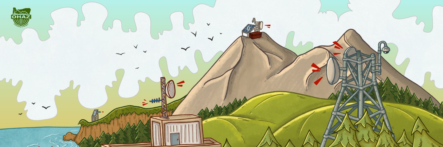
🔗Read our quarterly newsletter: bit.ly/OHAZJune2025 We share our plans for the upcoming field season, update you on #ShakeAlert #EEW partners, and highlight new wildfire detection cameras across Oregon!

Cascade Range volcanoes at normal background levels of activity this week: ow.ly/9JRI50WvzAo This infographic updates statistics on the Mount Rainier earthquake swarm. Seismicity continues to decline, with 75 quakes located in the past week (1000 overall since July 8).
Happy FieldworkFriday! We a GoPro to the skids of a helicopter for a recon flyover of St. Andrews Rock (STAR). The station is hard to spot on the ridge line that the helicopter circles. Flying above Mt Rainier really puts into perspective just how big this volcano actually is!
Thank you, wildland firefighters!
Give a firefighter a fist bump! 👊 Since last week, wildland firefighters in the Pacific Northwest have successfully contained or placed under patrol status nine large wildfires. Thank you, firefighters!
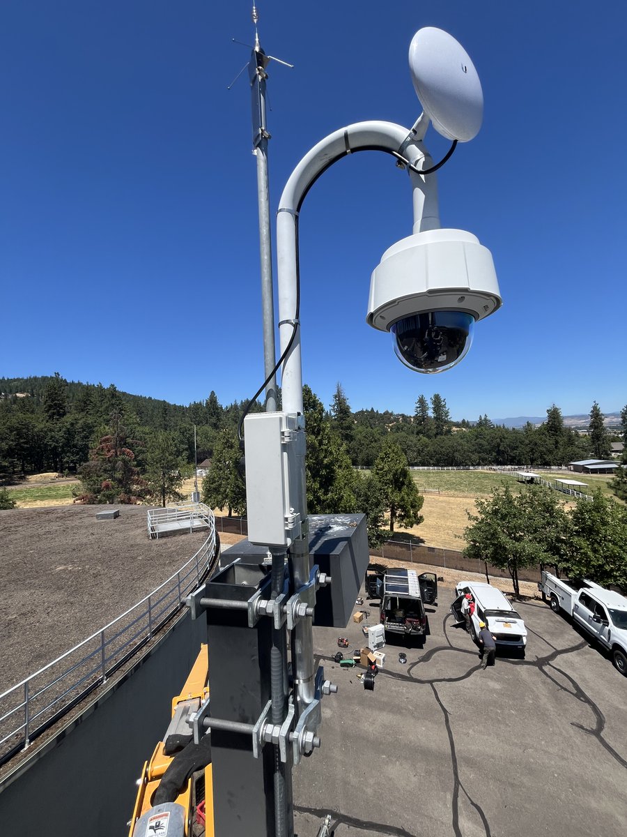
It's #FieldworkFriday! We deployed 2 new wildfire cameras in @JacksonCountyOR. The Jacksonville and @CentralPointOR cams give firefighters new tools to detect fires at the WUI. Read about our partnership with @fema and Rogue Valley Council of Governments: ohaz.uoregon.edu/project/rogue-….
ODF's Weekly Situation Report is to help create a snapshot of large fire information, weather and prevention information. To read the full report, visit odffire.com/2025/07/21/odf…
Currently, seven large fires are impacting national forest lands in the Pacific Northwest with a potential for new starts from thunderstorms east of the Cascades. Let’s all do our part to prevent human-caused fires – for our communities, firefighters and incredible landscapes.
🔥 95% of wildfires are caused by people. That means almost every fire that has threatened communities could have been prevented. Whether you're using equipment, towing a trailer, burning debris, or building a campfire—one mistake can spark disaster. Help us reduce the risk: 🚫…
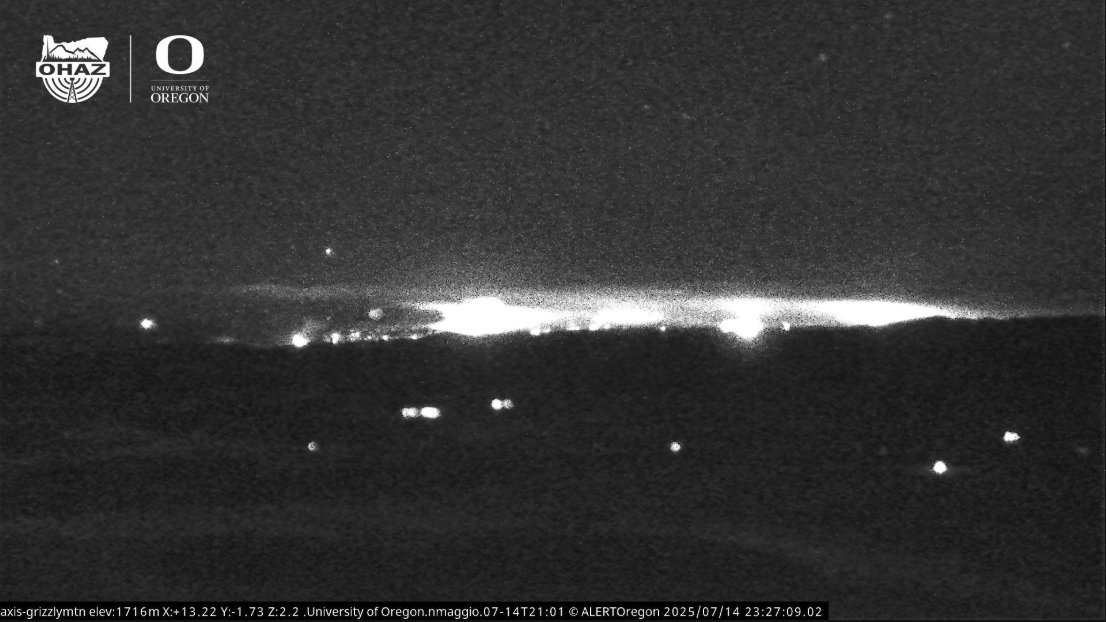
🔥This #WildfireWednesday we’re tracking the Cram Fire north of Madras. Shaniko & Grizzly Mtn cams are capturing smoke by day & heat at night using near infrared. 📍77% contained | 95,736 acres 🚨 Fire info: centraloregonfire.org 📱Watch: alertwest.live & Watch Duty

The Great Oregon ShakeOut is on October 16 at 10:16am! Register your participation in the world's largest earthquake drill at shakeout.org/oregon.
Have you spent time along Washington’s 3,000 miles of shoreline this summer? If so, did it get you wondering what you can do to reduce your tsunami risk? Wonder no longer, because #ShakeOut is on the way! #ShakeOut is the world’s largest annual earthquake and tsunami drill. 🌊
Why are some earthquakes so destructive, while others just cause minor damage? These 5 factors affect the impact: 🔸 magnitude 🔸 depth 🔸 local geology 🔸 population density 🔸 construction quality Some of these we can control to reduce risks. Watch to learn more ⏬
Did you hear today's story about OHAZ on @KLCCOregon? KLCC joined the HBO seismic site upgrade last week! Learn from @uoregon undergrads why they like working at OHAZ and how @pnsn1 seismic monitoring stations and @USGS_ShakeAlert improve resilience. klcc.org/disasters-acci…

The @USGS_ShakeAlert Earthquake Early Warning System detects earthquakes and alerts people in impacted areas before dangerous shaking arrives. #ShakeAlert works with many partners to deliver #EEW alerts - including Android! 🔗 Get alerts on your phone: usgs.gov/programs/earth…
A global Android smartphone-based earthquake detection and early warning system can detect seismic activity in real time and deliver life-saving alerts with effectiveness rivaling that of traditional seismic networks, according to a new study in Science. 📄:…
Cascade Range volcanoes at normal background levels of activity this week: ow.ly/s0hR50Ws2UG. This infographic updates statistics on the earthquake swarm at Rainier, which is continuing at low rates. More info at ow.ly/Iw0J50Ws2UI.
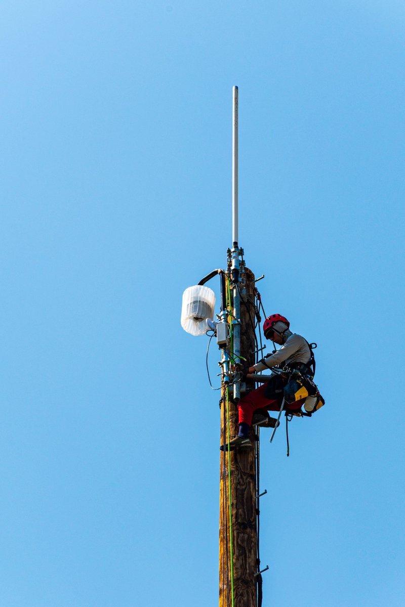
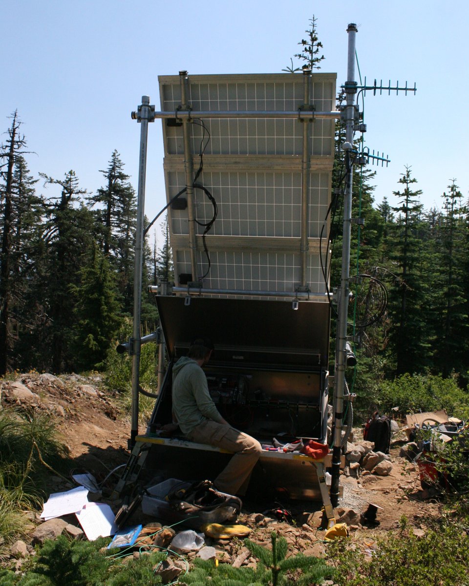
Happy #FieldWorkFriday! This week, we finished upgrading HBO, a @pnsn1 seismic monitoring station near Oakridge. HBO now has new technology and infrastructure, so it can collect real-time ground motion data for scientific research and @USGS_ShakeAlert for many more years!

Museums, libraries, park visitor centers & other free-choice learning institutions are participating in @ShakeOut ‘25. Your organization can too! Join us on 7/31 or 8/5 to find out how to get involved. Register: omsi.edu/events/shakeou… @UOHazardsLab @ECA @ScienceCenters @westmuse
NO tsunami threat to Oregon 🚫 We’re aware of the M7.3 earthquake near Sand Point, Alaska this afternoon. A Tsunami Advisory is in effect for parts of coastal Alaska, but 𝐎𝐫𝐞𝐠𝐨𝐧 𝐢𝐬 𝐧𝐨𝐭 𝐚𝐭 𝐫𝐢𝐬𝐤 for a tsunami at this time. Stay informed ➡️ tsunami.gov
Attending the 2025 Natural Hazards Workshop? Join us for the #ShakeAlert Ready panel at 9:45 am MT in Centennial F: hazards.colorado.edu/workshop/2025/… Meet members of the ShakeAlert Ready development and implementation team! @PNSN1 @UOHazardsLab @CAGeoSurvey @Cal_OES @OregonOEM
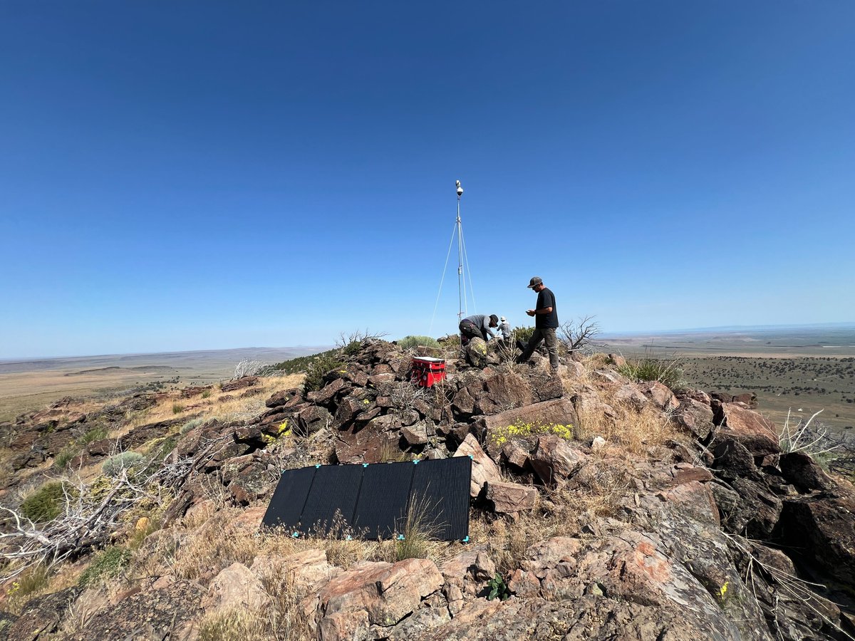
It’s #WildfireWednesday! Today we're highlighting the Mobile Unit on Jackass Butte. These portable wildfire camera kits can be rapidly deployed to monitor new wildfires. We set up Mobile Unit 2 at Jackass Butte last week to help @BLMOregon watch for wildfires in Harney County.
Attending the 2025 Natural Hazards Workshop? Come check out the #ShakeAlert Ready Outdoors (S3) and Schools (S5) posters tonight from 5:30 - 7 pm MT. Meeting info: hazards.colorado.edu/workshop/2025 Meet members of the ShakeAlert team! @PNSN1 @UOHazardsLab @CAGeoSurvey @Cal_OES @OregonOEM
Did you know that #ShakeAlert is one of earthquake information tools of the Advanced National Seismic System (ANSS)? Come meet the family 😀(poster M7) at the Natural Hazards Workshop. Can’t join us? Here is the poster: hazards.colorado.edu/uploads/poster… @PNSN1 @UOHazardsLab @USGS_Quakes