NWS Mobile
@NWSMobile
Official X account for the National Weather Service in Mobile/Pensacola. Details: https://www.weather.gov/nws_x
Check out this incredible capture from Maggie Quimby in Atmore, Alabama this evening. ⚡️🌈 Not everyday you get the best of both worlds in one view. Love it! @NWSMobile
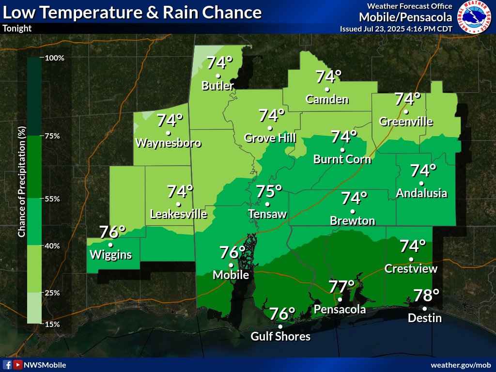
Another night of temperatures dropping into the low 70s along and north of Highway 84, mid 70s to Interstate 10, and upper 70s to around 80 south of I-10 to the coast. Evening showers and thunderstorms will diminish, then redevelop along and south of the coast late tonight.
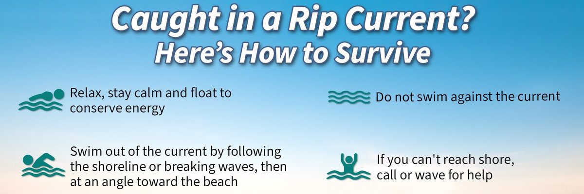
🚨 HEADS UP - HIGH #RipCurrent Risk at the coastal Alabama and northwest Florida beaches through this afternoon! 🌊 Strong rip currents are being reported at our northwest Florida beaches with red flags at all local beaches. 🏖️ Be #BeachSmart weather.gov/beach/mob
We often check the weather forecast before going to work or school — but do you know what forecasts to check before going to the beach? Tides, winds, and waves can lead to dangerous conditions - learn how to find the forecasts that matter most: oceantoday.noaa.gov/blueiq/blueiq-…
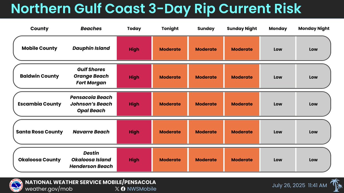
We are flying single red 🚩 and purple flags in Orange Beach today - Saturday, July 26. Single red flags represent High Hazard with High Surf/Strong Currents. Purple Flags are for Jellyfish. For your safety, we ask that you stay on the shore. 🎥: Cotton Bayou Beach. @spann #alwx
Caution: a Dense Fog Advisory is in effect for portions of south central Alabama until 10 am this morning for fog with visibilities down to around a quarter mile.

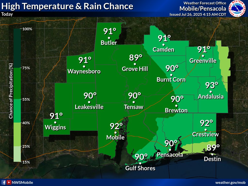
Showers and storms are likely today mainly across southeast Mississippi and southwestern Alabama, with a chance of rain elsewhere. Highs will be mostly in the lower 90s.
🌈 Full double rainbow in Atmore! @NWSMobile @spann @rzweather @KNBHwx @ThomasGeboyWX @WKRGEd @AlanSealls @KDanielCCI @StormHour @ThePhotoHour #ALwx
Happy Friday… Good morning 🌞 from Orange Beach, Alabama
#GulfCoast summer nights ⚡️⚡️⚡️what a week it’s been! 📸 Jason Taylor @mynbc15 @ThomasGeboyWX @natwxdesk @NWSMobile @spann
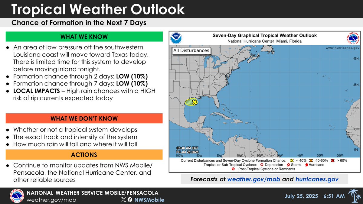
An area of low pressure about 100 miles south of southwestern LA will move towards TX today. This system has limited time and just a 10% chance to develop before moving inland tonight. For our area, high rain chances are expected today, with HIGH RISK of rip currents in effect.
An area of low pressure over the north-central Gulf will slowly move over the northwestern Gulf with a 10% chance of tropical development before moving into TX or western LA by this weekend. High rain chances are expected today for our area along with a HIGH RISK of rip currents.

Faint rainbow over the @City_of_Mobile skyline this evening! @mynbc15 @nwsmobile
Spotlight on the Southeast, which has seen pockets of dryness (and drought in AL) pop up and expand over the last month. Precipitation deficits over the past 30 days combined with the incoming heat wave may cause dryness to expand or intensify. drought.gov @NOAA
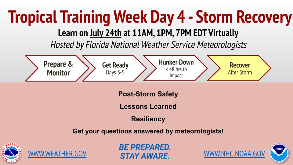
🌀 Today is Day 4 of Florida Tropical Training Week! Learn from NWS meteorologists about ✅post-storm safety ✅lessons learned from past hurricanes ✅resiliency ✅Q&A session, too! ⏰ 3 sessions: 11am, 1pm, 7pm EDT Register: weather.gov/jax/FloridaTro… 📌 #HurricanePrep #FLwx
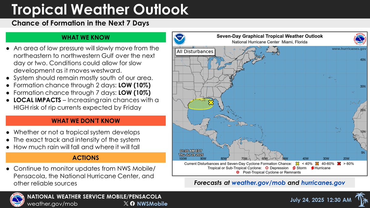
7 am update: an area of low pressure will slowly move westward across the north central to northwestern Gulf over the next day or two, and there is a 10% chance of tropical cyclone formation. High rain chances expected for our area today/Friday, and HIGH RISK in effect Friday.

An area of low pressure will move westward from the northeastern to northwestern Gulf over the next day or two, and there is a 10% chance of tropical cyclone formation. High rain chances are expected for our area on Thursday and Friday, with a HIGH RISK of rip currents Friday.
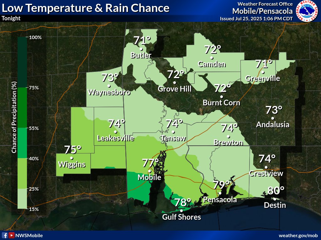
Increasing moisture levels across the area will maintain rain chances through the overnight hours. The highest rain chances will be south of I-10 and offshore tonight. Lows will be in the mid 70s inland to near 80 along the coast.