Thomas Geboy
@ThomasGeboyWX
Chief Meteorologist, @mynbc15. B.S. & M.S. from Mississippi State. @nwas seal holder. AP Award Winner. MS Gulf Coast Native. Go #RSL. Opinions are mine.
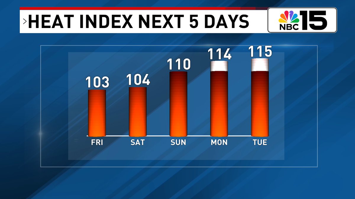
For the second half of the weekend into early next week expect sweltering heat 🥵♨🌡. Highs skyrocket into the mid to upper 90s with heat index values well over 110+ possibly up to 115 in spots. Check back for updates mynbc15.com/weather


The rip current risk 🌊🏊 is HIGH today & moderate this weekend. Waves in the surf zone will be 2 to 3 feet & the UV forecast is EXTREME. Moderate Chop in bays & coastal waters with seas 3 to 5 feet with coastal storms in store mynbc15.com/weather


#TGIF everybody! Scattered showers & storms will be around 🌧☔with about a 2/3 chance wet weather finds you. Some storms will be capable of heavy rain. The NBC 15 area is under a marginal excessive rainfall risk that could lead to flash flooding mynbc15.com/weather


Low formation chance remains on this broad area of low pressure over the Gulf. Slow development is possible as it moves WNW but by this weekend, it shifts inland over SE Texas or W Louisiana mynbc15.com/weather

HEADS UP - High risk of rip currents expected along our beaches tomorrow! @mynbc15 mynbc15.com/weather


Faint rainbow over the @City_of_Mobile skyline this evening! @mynbc15 @nwsmobile

Still a low chance the disturbance moving across the northern Gulf develops. It will move into Texas this weekend. @mynbc15 mynbc15.com/weather

High rain chances will keep temps in check again tomorrow, however, as high pressure builds this weekend, so will the temps 🥵. By early next week, we'll see highs in the mid to upper 90s with heat index values that could approach 115° 🔥. @mynbc15 mynbc15.com/weather


Lingering moisture will lead to high rain chances again to close out the workweek, but by the weekend we'll trend drier as high pressure builds back in. @mynbc15 mynbc15.com/weather


Flood Advisory is in effect for parts of S Baldwin County until 2:30PM. Bon Secour may experience flooding. Flood Advisory is also up in Okaloosa County until 3:15PM. Some locations impacted include Wright, Eglin AFB, Valparaiso, & Eglin Village mynbc15.com/weather


Happy Thursday Gulf Coast! Here are our views this morning from Mobile & Fairhope, #Alabama & Pensacola, #Florida. Clouds to start with rain action set to ramp up to 80% late day mynbc15.com/weather


A trough of low pressure over the N Gulf is bringing us higher rain chances & a high rip current risk by Fri. It'll move W across the north-central & NE Gulf. It has a low formation chance & likely moves inland this weekend mynbc15.com/weather


Rain chances 🌧☂80% today & 70% Fri as deep moisture moves from east to west across the N Gulf. Not all day wash-outs, but multiple waves of showers/storms. Level 1 excessive rainfall risk that could lead to flash flooding both days mynbc15.com/weather


Don't look now 👀, but after our high rain chances to end the workweek, high pressure will build back in this weekend. By Monday highs will be back in the mid to upper 90s with heat index values that could exceed 110° 🥵. @mynbc15 mynbc15.com/weather


Still a low, 10% chance we see the disturbance that will be moving across the northern Gulf in the coming days develop. The rest of the Atlantic is quiet. @mynbc15 mynbc15.com/weather

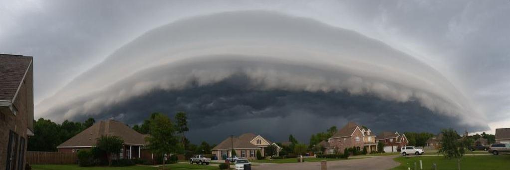
Heads up NWFL & Escambia Co. AL. A group of strong storms with heavy rain are approaching from the east. Flash flooding can’t be ruled out. As we move into the nighttime storms should start to fade, but this is something to keep an eye on in the next few hours.


Over the next couple of days most in our area will likely see 0.5-2" of rain, but locally higher/lower amounts will be possible. Our in-house model suggests some isolated pockets could see 4-7" of rain. @mynbc15 mynbc15.com/weather

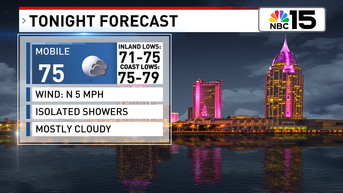
Most storms fade tonight, but isolated showers remain possible. Deep moisture will lead to high rain chances again tomorrow. Not likely to be all-day rain, but some spots could see multiple rounds. Skies will be partly sunny as highs ease down to around 90°. @mynbc15


High rain chances will keep temperatures in check over the next few days, but by the end of the weekend, high pressure will build back in. We'll be back in the mid to upper 90s by Monday 👀🔥. @mynbc15 mynbc15.com/weather


Heavy rain resulting in some street flooding in Orange Beach this afternoon. Rain chances will remain elevated the next few days and there will be a marginal excessive rainfall risk for our area both Thursday and Friday. Video from Mallory Landefeld. @mynbc15 @NWSMobile