
Live 5 First Alert Weather
@LIVE5WEATHER
The #1 Lowcountry weather team keeps you up-to-date with an accurate forecast with @BILLWALSHTV @JoeySovine @ChrisHoltzmanWx @stephaniesinewx and @MinorWX
TROPICS: The same front that's bringing rain to the Southeast will play a role in developing a tropical low this week! As of Tuesday night, @NHC_Atlantic has given this piece of energy a "low" chance of development once it enters the Gulf on Thursday and Friday. #Tropics #SCWX
FIRST ALERT: Rain remains in the forecast as a stationary front meanders into the Lowcountry! Plan for a few more showers tonight and early Wednesday before activity increases in coverage later in the day. #SCWX
FIRST ALERT: A "Coastal Flood Advisory" has been issued for the coastlines of Charleston and Colleton Counties until 8 PM. Minor coastal flooding is possible in low-lying areas, especially in flood-prone areas of Downtown Charleston. Light rain continues this evening. #SCWX
FIRST ALERT// Flood Advisory Extended Until 6:45 PM for parts of Berkeley, Dorchester, Colleton and Charleston Counties. Heavy rain and ponding on the roads causing some localized flooding issues. Also lots of lightning. These storms will diminish after dinner.
FIRST ALERT// Heavy Rainfall, Gusty Winds and Dangerous Lightning over the Tricounty area. Flood Advisory until 4:30 for parts of Berkeley, Dorchester and Charleston Counties. Storms will diminish after dinner, but localized flooding expected.
Sunrise view from Downtown Charleston to Mount Pleasant!
FIRST ALERT: Scattered downpours will bring us a well-needed break from the worst of the heat! Tuesday's highs should span the low/mid 90s with heat index values between 100-108°. Evening storms will be capable of producing isolated flash flooding. #SCWX
FIRST ALERT (3:20 PM) - A Flood Advisory is now in effect for Downtown Charleston, James Island and West Ashley until 6 PM. Rain rates of 1-2" are possible and are already causing instances of flooding in low-lying and poor drainage areas. #SCWX #CHSWX
FIRST ALERT// Already Dangerous Heat Index Temps Right Now // Stay cool & hydrated, take breaks, check on elderly folks and don't forget pets.
Temperatures have soared to near 90 degrees this morning. Factoring in temperatures near 90 degrees and the high humidity, the heat index is around 100 to 105 degrees. Many spots will feel like 108-112 degrees this afternoon.
The heat index along the coast is close to 100 degrees and it's only 5:15! Look for the heat index to approach if not exceed 108 degrees this afternoon and evening.
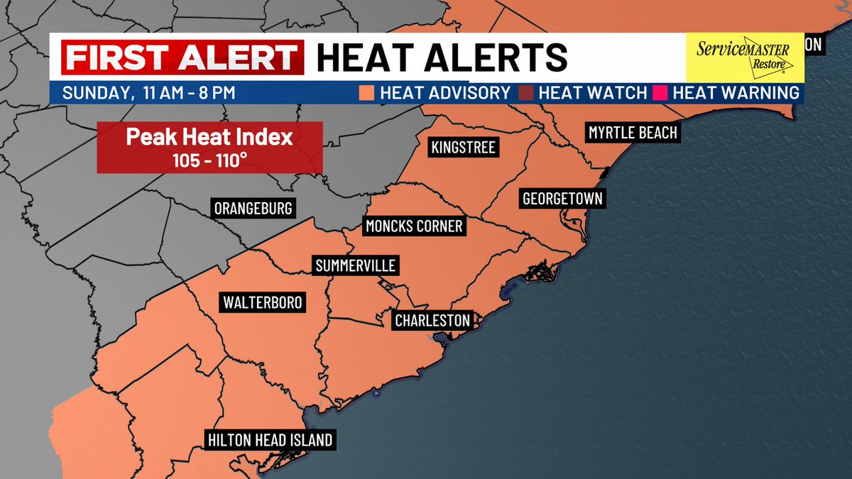
FIRST ALERT: Another Heat Advisory is in effect for Sunday from 11AM - 8PM. Highs forecasted in the upper 90s with Heat Index Values peaking around 105-110 degrees.
The heat index has surpassed 100 degrees along the coast and it's only 10:00! Temperatures will soar into the mid to upper 90s this afternoon and the heat index will approach if not exceed 108 degrees. A Heat Advisory remains in effect through the evening.
A HEAT ADVISORY is in effect from 11 AM through 8 PM. High temperatures today will be in the mid to upper 90s and when you factor in the humidity, it will feel like it's around 108-110 degrees. Make sure to take precautions if you will be outdoors for an extended period of time.
FIRST ALERT: You'll want to limit your time outside this weekend as dangerous heat and humidity persists! Temperatures will quickly rise into the mid/upper 90s inland Saturday and Sunday afternoons. Heat index values near 110° are expected. #SCWX