
Meteorologist Dorien Minor
@MinorWX
☀️ Meteorologist @Live5News 🌪 Founder of @easfinesse 🐝 @georgiatech & @georgiatecheas: B.S. '22, M.S. '23 ✈️ D(M)V - ATL - CHS ♦️ @kapsi1911 ✞ ✞ Matthew 6:33
I am elated to announce that I will be the newest Meteorologist at Live 5 News in Charleston, SC! I look forward to working with and learning from a prominent set of meteorologists and newscasters, and I'm excited to continue my journey in the Lowcountry! @Live5News @LIVE5WEATHER

FIRST ALERT: Rain remains in the forecast as a stationary front meanders into the Lowcountry! Plan for a few more showers tonight and early Wednesday before activity increases in coverage later in the day. #SCWX
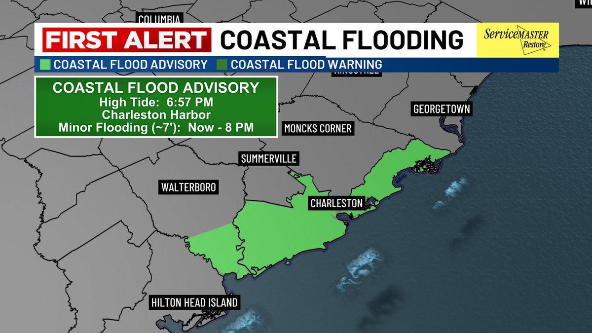
FIRST ALERT: A "Coastal Flood Advisory" has been issued for the coastlines of Charleston and Colleton Counties until 8 PM. Minor coastal flooding is possible in low-lying areas, especially in flood-prone areas of Downtown Charleston. Light rain continues this evening. #SCWX
FIRST ALERT (5 PM) - The Flood Advisory for Berkeley County and the Charleston Metro has been allowed to expire as heavy thunderstorms have pushed south and west. A new advisory is in place for parts of Clarendon County (including St. Paul and Summerton) until 6:45 PM. #SCWX
FIRST ALERT// Flood Advisory Extended Until 6:45 PM for parts of Berkeley, Dorchester, Colleton and Charleston Counties. Heavy rain and ponding on the roads causing some localized flooding issues. Also lots of lightning. These storms will diminish after dinner.
SEVERE THUNDERSTORM WARNING has been issued for parts of Orangeburg, Clarendon until 7/22 4:45PM. A Severe Thunderstorm can produce damaging winds and large hail. Take cover!
FIRST ALERT// Flood Advisory Extended Until 6:45 PM for parts of Berkeley, Dorchester, Colleton and Charleston Counties. Heavy rain and ponding on the roads causing some localized flooding issues. Also lots of lightning. These storms will diminish after dinner.
SEVERE THUNDERSTORM WARNING has been issued for parts of Charleston until 7/22 4:15PM. A Severe Thunderstorm can produce damaging winds and large hail. Take cover!
FIRST ALERT// Heavy Rainfall, Gusty Winds and Dangerous Lightning over the Tricounty area. Flood Advisory until 4:30 for parts of Berkeley, Dorchester and Charleston Counties. Storms will diminish after dinner, but localized flooding expected.
1:57pm CDT #SPC_MD 1754 , #scwx #gawx, spc.noaa.gov/products/md/md…
CHS issues Flood Advisory for Berkeley, Charleston [SC] till Jul 22, 4:30 PM EDT mesonet.agron.iastate.edu/vtec/f/2025-O-…
#WPC_MD 0776 affecting central SC/GA to coast, #ncwx #scwx #gawx, wpc.ncep.noaa.gov/metwatch/metwa…
FIRST ALERT: Scattered downpours will bring us a well-needed break from the worst of the heat! Tuesday's highs should span the low/mid 90s with heat index values between 100-108°. Evening storms will be capable of producing isolated flash flooding. #SCWX
SEVERE THUNDERSTORM WARNING has been issued for parts of Beaufort, Colleton until 7/21 9:15PM. A Severe Thunderstorm can produce damaging winds and large hail. Take cover!
FIRST ALERT (7 PM) - Downtown Charleston's "Flood Advisory" has expired, but residual standing water remains in a few locations! You can check on the latest road closures in Downtown by visiting @Live5Traffic or by clicking the link below: gis.charleston-sc.gov/road-closures-… #CHSTRFC
FIRST ALERT (3:20 PM) - A Flood Advisory is now in effect for Downtown Charleston, James Island and West Ashley until 6 PM. Rain rates of 1-2" are possible and are already causing instances of flooding in low-lying and poor drainage areas. #SCWX #CHSWX
FIRST ALERT// Already Dangerous Heat Index Temps Right Now // Stay cool & hydrated, take breaks, check on elderly folks and don't forget pets.
Temperatures have soared to near 90 degrees this morning. Factoring in temperatures near 90 degrees and the high humidity, the heat index is around 100 to 105 degrees. Many spots will feel like 108-112 degrees this afternoon.
The heat index along the coast is close to 100 degrees and it's only 5:15! Look for the heat index to approach if not exceed 108 degrees this afternoon and evening.
A HEAT ADVISORY is in effect from 11 AM through 8 PM. High temperatures will be in the mid/upper 90s and when you factor in the humidity, the heat index will approach if not exceed 108 degrees. Make sure to take precautions if you will be outdoors for an extended period of time.
Hot, Hot, Hot! Another HEAT ADVISORY has been issued for Sunday from 11AM - 8PM as feels-like temperatures peak around 105-110°! Take it easy out there !!🥵 #charleston #chswx
The heat index has surpassed 100 degrees along the coast and it's only 10:00! Temperatures will soar into the mid to upper 90s this afternoon and the heat index will approach if not exceed 108 degrees. A Heat Advisory remains in effect through the evening.