
Joey Sovine Live 5
@JoeySovine
AMS Certified Broadcast Meteorologist. Morning/Noon weather on @Live5News in Charleston, SC. Cleveland/Virginia Tech sports guy! Chanel’s husband, dad of 2.
TROPICS: The same front that's bringing rain to the Southeast will play a role in developing a tropical low this week! As of Tuesday night, @NHC_Atlantic has given this piece of energy a "low" chance of development once it enters the Gulf on Thursday and Friday. #Tropics #SCWX
FIRST ALERT: A "Coastal Flood Advisory" has been issued for the coastlines of Charleston and Colleton Counties until 8 PM. Minor coastal flooding is possible in low-lying areas, especially in flood-prone areas of Downtown Charleston. Light rain continues this evening. #SCWX
SEVERE THUNDERSTORM WARNING has been issued for parts of Orangeburg, Clarendon until 7/22 4:45PM. A Severe Thunderstorm can produce damaging winds and large hail. Take cover!
FIRST ALERT// Flood Advisory Extended Until 6:45 PM for parts of Berkeley, Dorchester, Colleton and Charleston Counties. Heavy rain and ponding on the roads causing some localized flooding issues. Also lots of lightning. These storms will diminish after dinner.
SEVERE THUNDERSTORM WARNING has been issued for parts of Charleston until 7/22 4:15PM. A Severe Thunderstorm can produce damaging winds and large hail. Take cover!
FIRST ALERT// Heavy Rainfall, Gusty Winds and Dangerous Lightning over the Tricounty area. Flood Advisory until 4:30 for parts of Berkeley, Dorchester and Charleston Counties. Storms will diminish after dinner, but localized flooding expected.
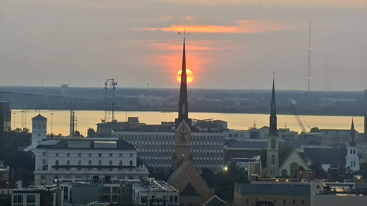
Sunrise view from Downtown Charleston to Mount Pleasant!
SEVERE THUNDERSTORM WARNING has been issued for parts of Beaufort, Colleton until 7/21 9:15PM. A Severe Thunderstorm can produce damaging winds and large hail. Take cover!
FIRST ALERT (3:20 PM) - A Flood Advisory is now in effect for Downtown Charleston, James Island and West Ashley until 6 PM. Rain rates of 1-2" are possible and are already causing instances of flooding in low-lying and poor drainage areas. #SCWX #CHSWX
FIRST ALERT// Already Dangerous Heat Index Temps Right Now // Stay cool & hydrated, take breaks, check on elderly folks and don't forget pets.
Temperatures have soared to near 90 degrees this morning. Factoring in temperatures near 90 degrees and the high humidity, the heat index is around 100 to 105 degrees. Many spots will feel like 108-112 degrees this afternoon.
The heat index along the coast is close to 100 degrees and it's only 5:15! Look for the heat index to approach if not exceed 108 degrees this afternoon and evening.
A HEAT ADVISORY is in effect from 11 AM through 8 PM. High temperatures will be in the mid/upper 90s and when you factor in the humidity, the heat index will approach if not exceed 108 degrees. Make sure to take precautions if you will be outdoors for an extended period of time.
The heat index has surpassed 100 degrees along the coast and it's only 10:00! Temperatures will soar into the mid to upper 90s this afternoon and the heat index will approach if not exceed 108 degrees. A Heat Advisory remains in effect through the evening.
A HEAT ADVISORY is in effect from 11 AM through 8 PM. High temperatures today will be in the mid to upper 90s and when you factor in the humidity, it will feel like it's around 108-110 degrees. Make sure to take precautions if you will be outdoors for an extended period of time.
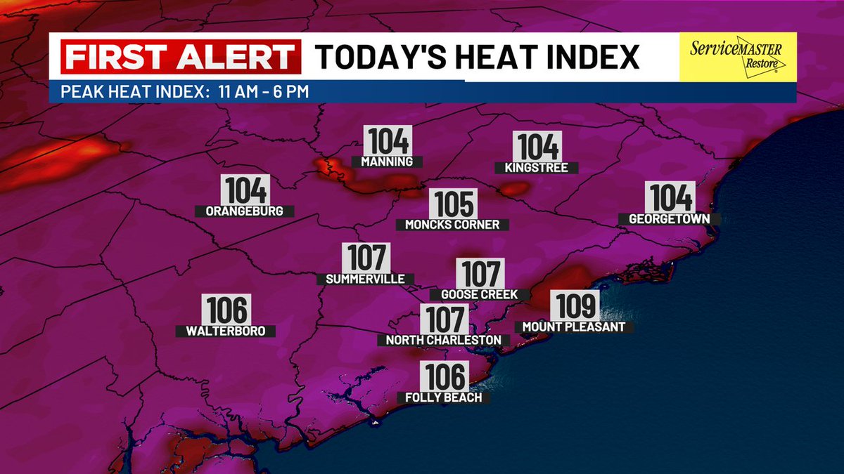
DANGEROUS HEAT: Feels-like temperatures climbed towards dangerous levels on Friday, with most of the Lowcountry seeing values above 105°! Heat Advisory criteria (108+° in the Metro) verified in the following locations, and more may be added to the list this weekend! #SCWX #CHSWX
FIRST ALERT: A Flood Advisory has been issued until 4PM Friday 7/18 for Berkeley, Charleston and Dorchester counties. Possible impacts include minor flooding and ponding on roadways.
FIRST ALERT: Friday Radar Update - Afternoon showers and thunderstorms picking up along the sea breeze! Heavy rainfall, gusty winds and dangerous lightning with these storms. Be careful on the roads!
HEAT INDEX 105 - 110°!🥵 A Heat Advisory is in effect for Georgetown and Williamsburg counties today! Elsewhere - no advisory but as hot, if not hotter. The criteria is a little lower in our northern counties compared to elsewhere.
FIRST ALERT: Heat Advisories have been issued for Williamsburg and Georgetown Counties in advance of Friday's hotter temperatures! Heat index values for the entire Lowcountry will rise to between 105-108° Friday afternoon. Values could be a touch higher this weekend. #SCWX