
Kristen Kirchhaine
@KristenWeather
Meteorologist @tmj4 in SE Wisconsin. Lover of cats. @ualr & @msstate graduate. @nwas Sealholder.
MAJOR HEAT MONDAY - Feels like temperatures will top 100° Monday afternoon, be sure to take extra care to stay cool! Thankfully the heat breaks by mid-week, see the ups and downs in your full forecast: tmj4.com/weather #wiwx
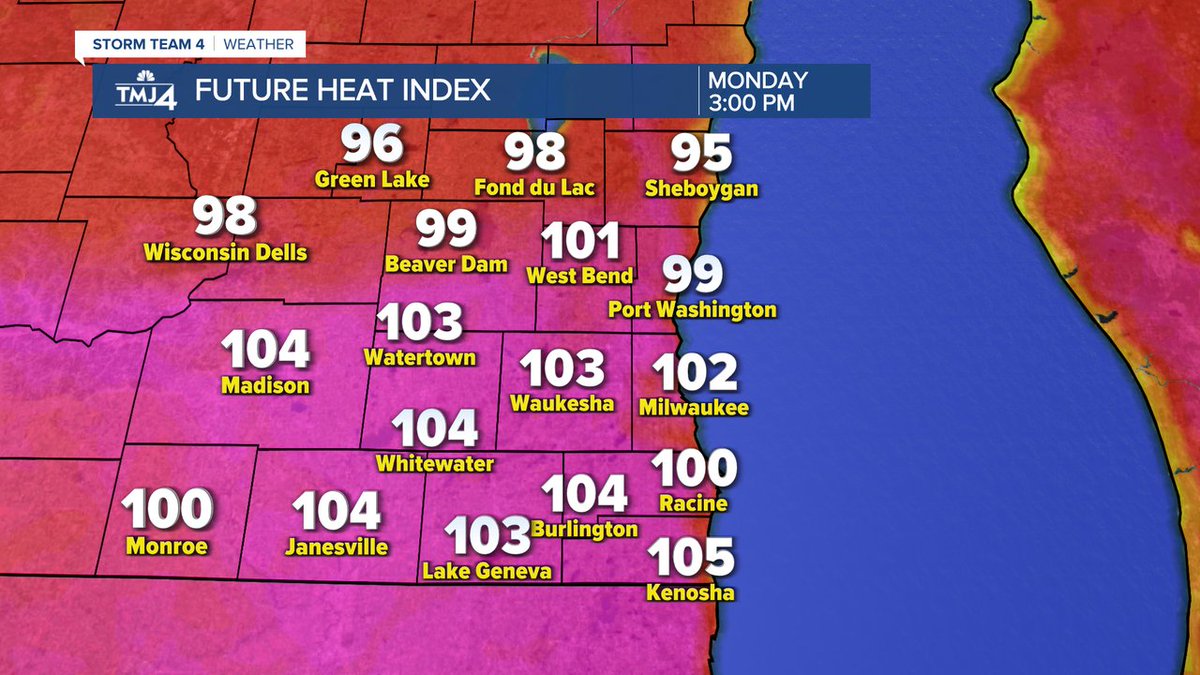
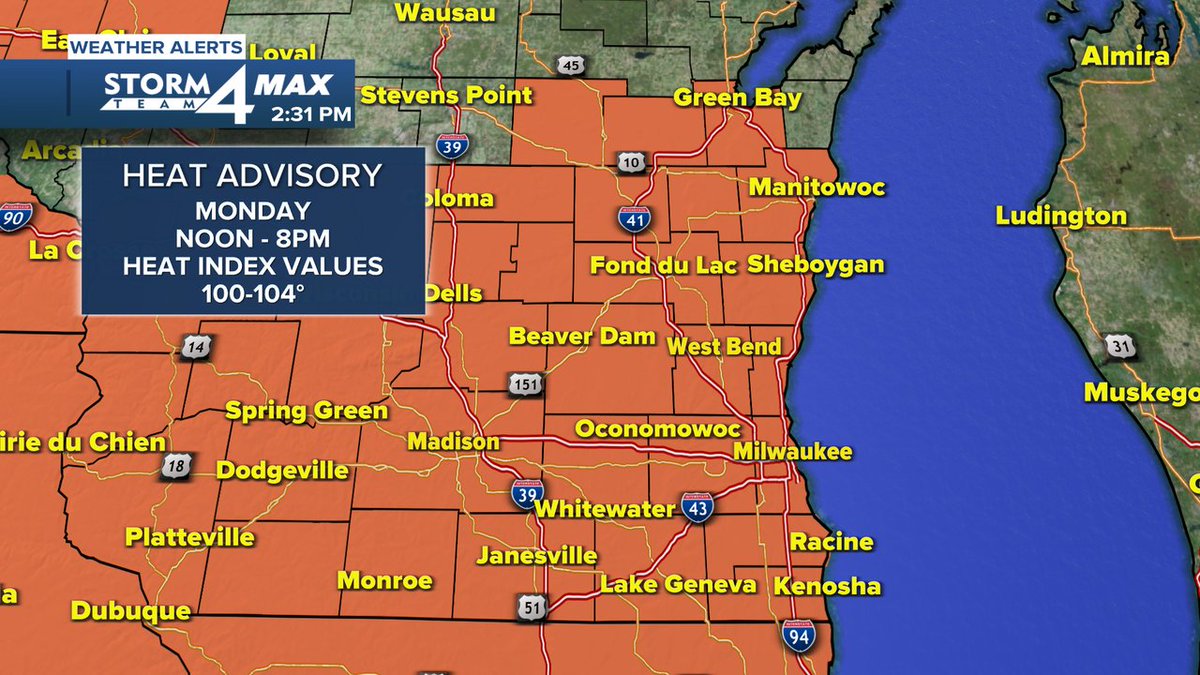
HEAT ADVISORY MONDAY - The combination of hot temperatures and high humidity will cause heat index values to climb to over 100° on Monday. Take necessary precautions to stay cool, check on relatives and neighbors, and take care of pets. #wiwx
A decaying complex of storms is expected to push southward toward the region early Monday morning. There is considerable uncertainty about the exact track and strength of these storms. If they hold together, gusty winds and lightning will be possible.
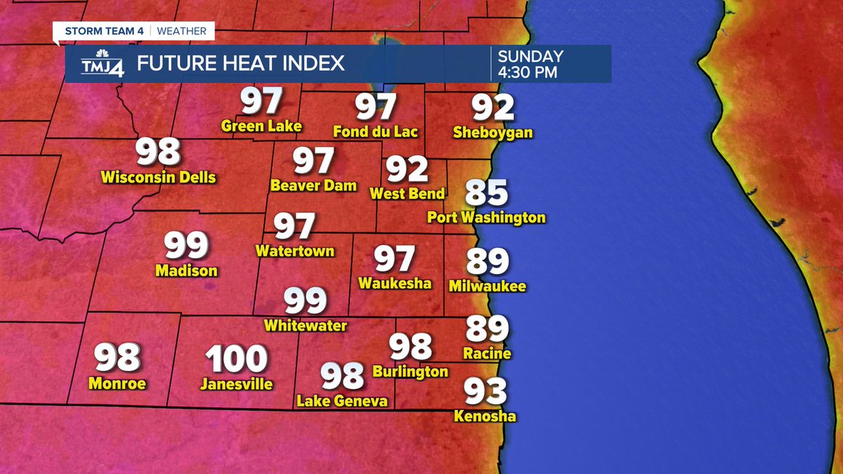
HOT & HUMID SUNDAY - The combination of heat and humidity will make it feel like temperatures are in the mid to upper 90s Sunday afternoon. Stay cool and hydrated! Monday looks even warmer, see the full forecast: tmj4.com/weather #wiwx
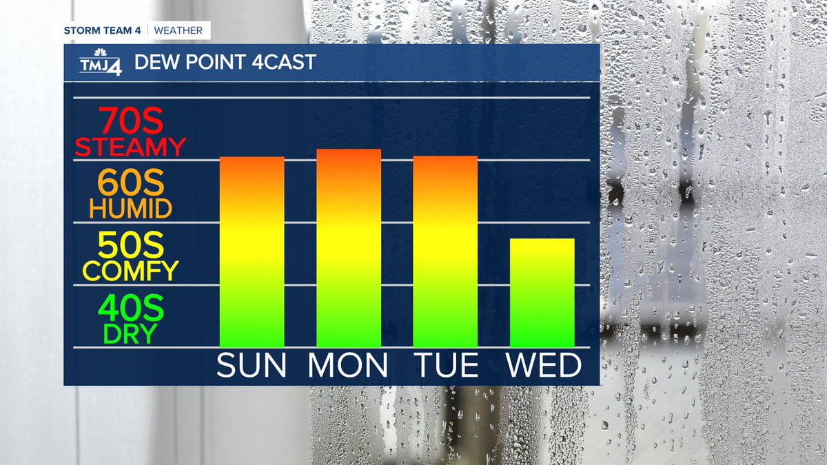
It stays steamy the next few days, but a cold front will come through late Tuesday, bringing relief from the humidity (and the heat). #wiwx
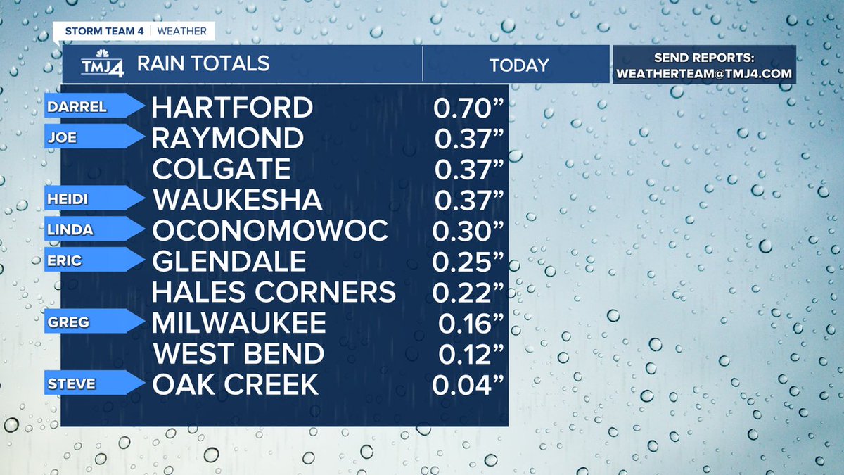
We saw highly varied rain totals on Saturday. How much did you see at your place?
🗣️ Wisconsin is drought-free!! 🗣️ As of yesterday's update to the US Drought Monitor, only two splotches of abnormal dryness remain along portions of the southern state line. #wiwx
Occasional rain and thunderstorms are expected today, with torrential rainfall expected at times. Rain will end by late afternoon, with fog looking increasingly likely tonight. Some dense fog is possible. Hot and humid weather is then expected for Sunday and Monday.
11:00a UPDATE -- @NWSMilwaukee has confirmed two tornadoes in Dodge County from yesterday's storms. Both exhibited EF-0 strength with max winds of 70 mph. Two survey teams have been deployed in southern Wisconsin today.
A Severe Thunderstorm Warning is in effect until Jul 16 6:00PM for Sheboygan counties. Stay with @TMJ4 for updates. #wiwx
A Severe Thunderstorm Warning is in effect until Jul 16 6:00PM for Ozaukee, Washington counties. Stay with @TMJ4 for updates. #wiwx
A Severe Thunderstorm Warning is in effect until Jul 16 5:45PM for Sheboygan counties. Stay with @TMJ4 for updates. #wiwx
A Flash Flood Warning is in effect for Fond du Lac counties until Jul 16 7:45PM. Do not drive through flooded waters. Seek higher ground if flooding is occurring in your area.
A Severe Thunderstorm Warning is in effect until Jul 16 4:45PM for Jefferson, Dodge, Waukesha counties. Stay with @TMJ4 for updates. #wiwx
A Severe Thunderstorm Warning is in effect until Jul 16 4:30PM for Dodge, Fond du Lac, Columbia, Green Lake counties. Stay with @TMJ4 for updates. #wiwx
A Tornado Warning is in effect for Columbia, Dodge, Dane counties until Jul 16 4:00PM. Seek shelter in the basement or an interior room until the storm has passed.
A Tornado Warning is in effect for Fond du Lac counties until Jul 16 4:00PM. Seek shelter in the basement or an interior room until the storm has passed.
A Tornado Warning is in effect for Columbia, Dodge counties until Jul 16 4:00PM. Seek shelter in the basement or an interior room until the storm has passed.
A Tornado Warning is in effect for Dodge counties until Jul 16 4:00PM. Seek shelter in the basement or an interior room until the storm has passed.
A Severe Thunderstorm Warning is in effect until Jul 16 4:00PM for Dane, Columbia, Dodge, Jefferson counties. Stay with @TMJ4 for updates. #wiwx