I-65 Weather (Kentucky)
@I65WxSils
Weather Forecasts & Analysis for SoKY/I-65 Corridor & @0meterChasers. @SKYWARN Spotter for @NWSLOUISVILLE. #WKU Alum, former TV Met in WY #kywx #I65Wx.
Have YOU hopped on board to the 🚂 Choo-Choo! We are LOCAL Storm Chasers/Broadcasters who will stream LIVE on the ground footage to our broadcasts, along with providing forecast analysis, daily weather updates while keeping you calm & 🚨 x.com/0meterchasers?…
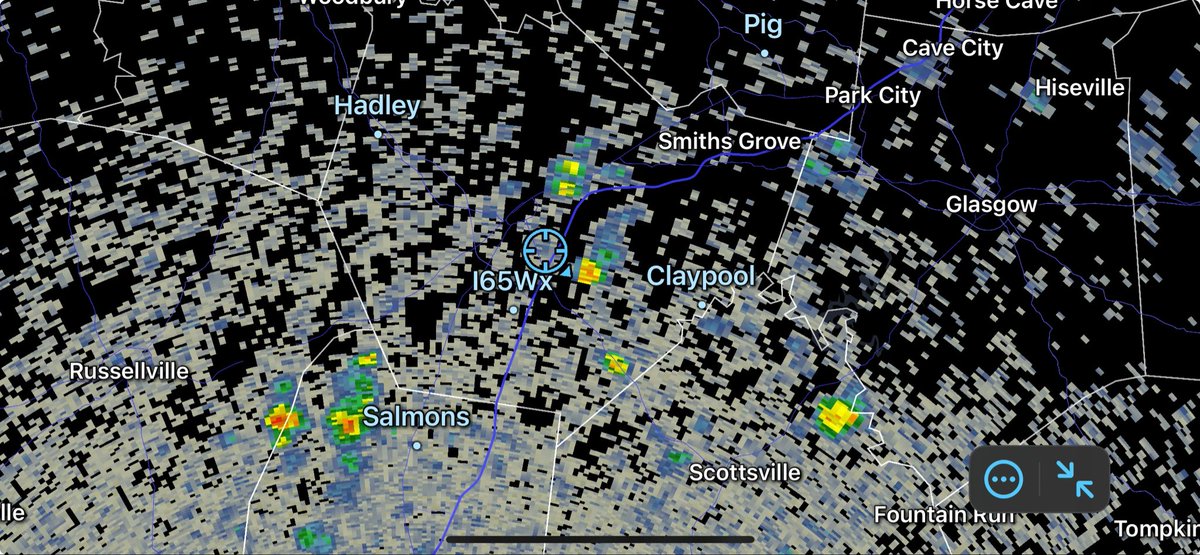
Just before Noon and Isol’d showers are beginning to percolate across the Region drifting N & E.
Here’s TODAYS & your 7-Day Forecast! Next week looks good so far!.. drier humidity values and a touch cooler
Nice little cloud growth around the Fern Creek area 😍☁️ #kywx @MarcWeinbergWX @NWSLouisville @BryceJonesWx @I65WxSils @Kentucky_WX @tystorm101
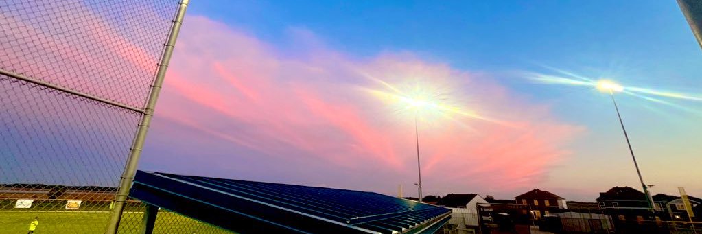
Beautiful sunrise this morning on Seagrove Beach, FL @jsmithwx @spann @I65WxSils
Don’t see many of these… An Extreme Heat Watch has been issued for Early Next Week for Western KY. Heat Indices of 110°+ is possible from Henderson-Hop’Town and points WEST. Via @nwspaducah -Mike
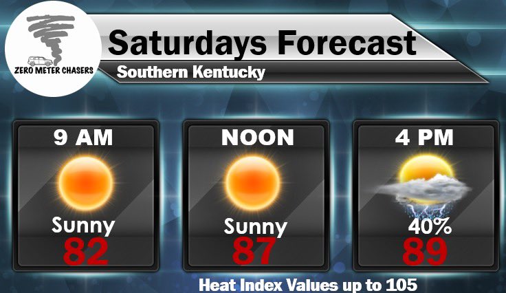
SAME ‘ole Song & Dance. Heat Advisory continues for SATURDAY. Not like we knew it wasn’t going to happen (sarcasm)…
Few Isol’d storms trying to pop up now; clouds are percolating above us in SoKY.
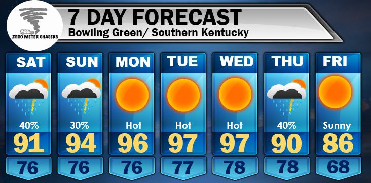
Here’s your Updated 7-Day Forecast for Southern KY: Garden Variety Storm chances for late today through Sunday as a Ridge breaks down a bit. BUT the Heat cranks back up by Sunday thru middle of next week as a new Ridge builds in from the West with *Hotter* temperatures. RELIEF…
Rinse & Repeat
Here’s yours forecast for Friday 7/25: Another muggy and humid afternoon in the mid-90°s with chances of rain very Isolated. -Mike
If you want slight relief from the Heat, I can slowly see it coming.
DOWN THE ROAD: What I am watching for next week continues to be the HOT temperatures in the mid-upper 90°s potential. BUT, I see relief in sight. The Ridge wants to buckle and break as some *cooler air* look to usher in by late next week-weekend. FINGERS CROSSED for some…
We’ll do it all over again…. On Friday.
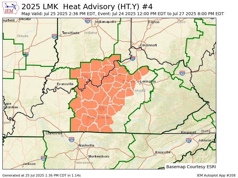
A Heat Advisory has been issued for all of southern Indiana and parts of central Kentucky for Friday afternoon and evening. #INwx #KYwx
Northwest KY is on 🔥
Northwest got little toasty today via @kymesonet Heat Indices were 110°+… even 116° in Dixon! Elsewhere many exceeded the Century mark. -Mike
Well… they come in 3’s… RIP to the Hulkster. #HulkHogan
All in the Family 😂
TV Trivia! 📺 Can you name this television show?

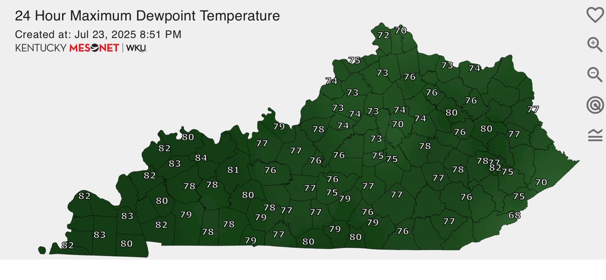
It was mentioned earlier tonight by @MarcWeinbergWX but with all the recent rains, impressive dewpoint temperatures today as some exceeded over 80° of a dT! 83° dT for Mayfield and Benton. Via @kymesonet
CURRENT Heat Related Hazards for the Lower OH & TN Valleys. Heat Indices continue to be in the Mid-Mississippi Valley for THURSDAY.
“Ohh Ed, you looked just like Dirty Harry”
🎉Edie McClurg turns 80 today
The streets of Bowling Green next week.
Down the Road: As I was forecasting earlier and looking into next week, it looks like we could get *Even Hotter* based on Operational & Ensemble guidance. Not getting nerdy, but if we limit rain rain chances and drier soil moisture, mid-upper 90°s are possible for Monday thru…
Here are the Max Heat Index Values so far today across KY as of 250pm EDT #KYwx via the @kymesonet