Zero Meter Chasers
@0meterChasers
Accredited Meteorologists that provide live weather coverage. Storm Chasers that emphasize in Public Safety. Business inquiries: [email protected]
Heat Indices already up in the 105-110° range over in Jackson Purchase region of Western KY. Touch cooler, but still creeping near the Century mark along the I-65 Corridor at the Noon hour.

Next weekend folks… Low to Mid-80°s for Highs?!!!!!! Sign me Up. Not *set in stone* but trends continue x-hv1.pivotalweather.com/maps/cpc/lates…

Today will make the 25th straight day reaching 90°+ in Nashville. It's the longest such run since the summer of 2022, when we did it 28 days in a row. In fact, 25 straight 90° days has only happened 10 other times in Nashville's history. The record is 34 back in 2007.
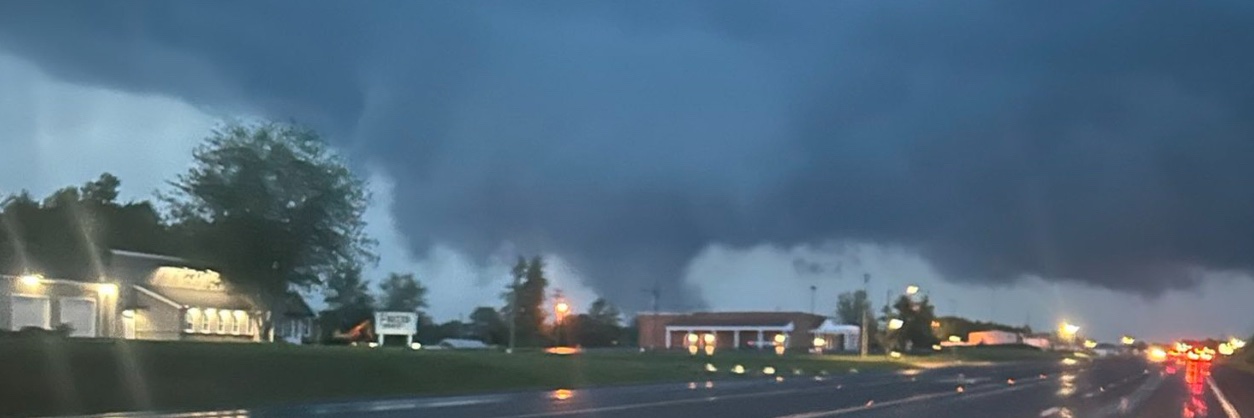
Just before Noon and Isol’d showers are beginning to percolate across the Region drifting N & E.
Here is your Updated 7-Day Forecast: Garden variety storms thru the weekend but turning HOTTER as I’ve mentioned for several days as a Ridge moves to the Midwest. If we get through Wednesday the relief comes in by late Thursday as a Cold Front will cool us down and *Drier*…

Don’t see many of these… An Extreme Heat Watch has been issued for Early Next Week for Western KY. Heat Indices of 110°+ is possible from Henderson-Hop’Town and points WEST. Via @nwspaducah -Mike

LMK extends time of Heat Advisory till Jul 27, 8:00 PM EDT mesonet.agron.iastate.edu/vtec/f/2025-O-…
Clouds are increasing across the Region as you see on Satellite this afternoon. Best convective or organized storms look to be well North over Central IN. We can see Isol’d showers pop up thru the day still. -Mike
Here’s your Updated 7-Day Forecast for Southern KY: Garden Variety Storm chances for late today through Sunday as a Ridge breaks down a bit. BUT the Heat cranks back up by Sunday thru middle of next week as a new Ridge builds in from the West with *Hotter* temperatures. RELIEF…

Here’s yours forecast for Friday 7/25: Another muggy and humid afternoon in the mid-90°s with chances of rain very Isolated. -Mike

DOWN THE ROAD: What I am watching for next week continues to be the HOT temperatures in the mid-upper 90°s potential. BUT, I see relief in sight. The Ridge wants to buckle and break as some *cooler air* look to usher in by late next week-weekend. FINGERS CROSSED for some…


Northwest got little toasty today via @kymesonet Heat Indices were 110°+… even 116° in Dixon! Elsewhere many exceeded the Century mark. -Mike

Here is your 7-Day Forecast for Bowling Green/SoKY: Ridge of High Pressure breaks down a bit for the weekend as scattered storm chances resume. However, a new Ridge builds in from the West to beg of next Week. If rain chances are limited, I can see temperatures be *HOTTER* by…

Corn 🌽 sweating 🥵 for some today. -Mike
It was mentioned earlier tonight by @MarcWeinbergWX but with all the recent rains, impressive dewpoint temperatures today as some exceeded over 80° of a dT! 83° dT for Mayfield and Benton. Via @kymesonet
CURRENT Heat Related Hazards for the Lower OH & TN Valleys. Heat Indices continue to be in the Mid-Mississippi Valley for THURSDAY.

Down the Road: As I was forecasting earlier and looking into next week, it looks like we could get *Even Hotter* based on Operational & Ensemble guidance. Not getting nerdy, but if we limit rain rain chances and drier soil moisture, mid-upper 90°s are possible for Monday thru…

The 7-Day Forecast will resume tomorrow morning. Been away for a few days due to some family obligations but we will back at it on Thursday. FYI, *No Relief* in a cool down just yet. -Mike
Farther WEST into the Jackson Purchase Region of KY, an Excessive Heat Warning has been issued where Heat Indices can exceed up to 110° This *does* include Paducah, Mayfield & parts of Northwest TN and MO Bootheel, Southern IL.

HEADS UP for Wednesday: A Heat Advisory will be issued tomorrow by the @nwslouisville from parts of I-65 & points WEST. Heat Indices in this region will likely exceed up to 105° This area shaded covers their CWA (County Warning Area).

Apparent Heat Indices are crazy in the Miss Valley and the Ozarks.. Found one reading ~ at 120° is insane. Dewpoints in this Region are hovering at 80°! This is why this part of the country is under an Excessive Heat Warning.
