NWS Louisville
@NWSLouisville
Official X account for the National Weather Service in Louisville. Details: https://www.weather.gov/nws_x
With the ongoing Heat Advisory, take a minute to practice heat safety while watching out for those around you. #INwx #KYwx

A Heat Advisory has been issued for all of southern Indiana and parts of central Kentucky for Friday afternoon and evening. #INwx #KYwx

Hot and humid weather continues making it feel it is 105-110 at times through the weekend and into next week. #INwx #KYwx

A Heat Advisory has been issued for all of southern Indiana and parts of central Kentucky for this afternoon and evening. #INwx #KYwx
Elevated heat indices continue for the next week. #INwx #KYwx

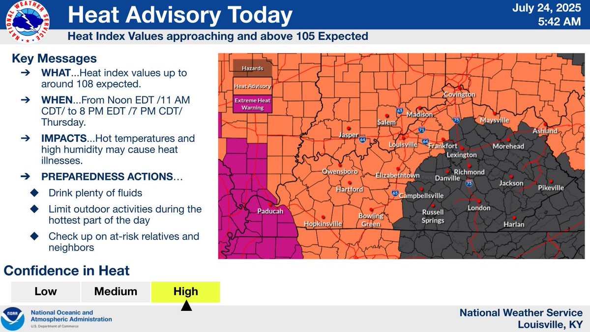
Heat Advisory in effect Thursday in southern Indiana, and west of a line from near Frankfort to near Scottsville. Afternoon heat index values of 103 to 108 could cause heat related illnesses, especially for at-risk populations and those engaged in strenuous outdoor activity

High heat and humidity will persist well into next week with triple digit heat index values each afternoon. #kywx #inwx

High heat and humidity will persist well into next week with triple digit heat index values each afternoon. #kywx #inwx

Here are the Max Heat Index Values so far today across KY as of 250pm EDT #KYwx via the @kymesonet

A Heat Advisory will go into effect this afternoon for areas along and west of a line from Jasper, IN to Scottsville, KY. Be sure to take all necessary heat-related precautions during the hottest part of the day.

The heat and humidity increase today, with an extended period of hot and humid weather expected through at least early next week. Chances for showers and storms will remain low over the next few days, with a few storms possible this weekend.

Heat advisory will be in effect for locations west of I-65 on Wed. afternoon with the rest of us with heat index values near or over 100 degrees. Complete forecast: weather.gov/louisville


Areas of fog this morning will give way to mostly sunny skies with temperatures warming into the upper 80s and lower 90s by this afternoon. Most should remain dry today with only a stray pop-up shower or storm expected.

A special weather statement has been issued for Glasgow KY, Cave City KY and Brownsville KY until 4:45 PM CDT

A special weather statement has been issued for Brownsville KY and Lindseyville KY until 4:00 PM CDT

A special weather statement has been issued for Beaver Dam KY, McHenry KY and Rosine KY until 3:15 PM CDT

An extended stretch of hot temperatures accompanied by high dew points is expected from Wednesday through at least Friday. As a result, heat index values will reach above 105 degrees for some locations. Limit outdoor activities and remain hydrated!

A special weather statement has been issued for Scottsville KY, Fountain Run KY and Lucas KY until 2:30 PM CDT

A special weather statement has been issued for Lucas KY until 2:00 PM CDT
