eweather
@Eweather13
Forecasts-Photography-Community. Download the free app today! When you seeweather, eweather! #CTwx #RIwx #MAwx #CTRiver #BlockIsland 📷🛥✈️🍷🍺⛷🚴🏿🌅
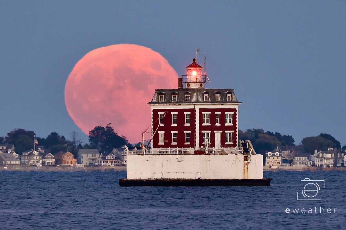
Another capture of the full #HuntersMoon rising behind Ledge Light in New London tonight! #ThePhotoHour @thedayct
🛥️⛵️Boaters…Seas around 2 feet this morning across near shore waters including Block Island Sound, building to 3’ later today as those SW winds increase later. Short durations of 4-5 seconds with quite a bit of chop developing. But no small craft advisory until you get into NE…
⚠️Friday: ☀️🌤️⛈️🌬️ Sunny during the morning trending toward a mix of clouds and sun. Hot and oppressively humid with dew points in the 70s. Scattered afternoon and evening thunderstorms developing. Some storms may be strong to severe. Highs in the low to mid 90s, except 80s at…


🛥️⛵️🌊Boaters… those Southwest winds continue today. Expect choppy seas around 3 feet across near shore waters, including Block Island sound. LI Sound around 2’ east, 1-2’ west. I don’t expect much if any fog today. However, keep an eye to the sky later today for strong…
Sunday: 🌦️⛈️⛅️ Partly sunny with scattered showers and thunderstorms moving through during the morning into afternoon from west to east. Highs range from the upper 70s to mid 80s across SNE. Turning humid once again.


Saturday: 🌤️ Mostly sunny and less humid. Highs in the 80s….coolest across coastal areas of MA, RI and SE CT where temps struggle to hit 80°.

Here’s the NAM idea compared with HRRR idea below.
⚠️ Today: ☀️🌤️⛈️🌬️ Sunny during the morning trending toward a mix of clouds and sun. Hot and oppressively humid with dew points in the 70s. Scattered afternoon and evening strong to severe thunderstorms. Highs in the low to mid 90s, except 80s at the SE beaches and in the western…
⚠️ Today: ☀️🌤️⛈️🌬️ Sunny during the morning trending toward a mix of clouds and sun. Hot and oppressively humid with dew points in the 70s. Scattered afternoon and evening strong to severe thunderstorms. Highs in the low to mid 90s, except 80s at the SE beaches and in the western…


Good morning! Temps and dew points are in the upper 60s and low 70s this morning. A muggy feel ahead of what will be a hot and oppressively humid day. A heat advisory continues for much of SNE - and today it’s really needed as the heat index inland gets up over 100° in many…


⚠️ Oppressively hot tomorrow with strong to severe storms during the afternoon into the evening. Not much has changed with the forecast…heat advisories are in effect for much of SNE. SE coastal areas and the Berkshires are excluded. Inland temps get into the low to mid 90s and…


Saturday: 🌤️⛅️ A mix of clouds and sun. Highs in the 80s….coolest across coastal areas of MA, RI and SE CT where temps stay closer to 80°. Less humid as dew points fall back to the low 60s. Sunday: ⛅️🌧️⚡️ Partly sunny with scattered showers possible mid to late afternoon,…

Today: 🌤️☀️🌬️ Mostly sunny. Humidity slowly increases through the day. Breezy SW winds develop - especially later today at the coast. Highs in the mid 80s to around 90° inland. A touch cooler at the SE beaches where temps stay around 80° due to that onshore SW breeze. A heat…


Good morning! Temps range from the upper 50s to upper 60s across SNE this morning with those mildest temps across coastal areas. Dew points generally in the upper 50s to lower 60s, so not as crisp, but not too bad. We are warmer and turn more humid today…a heat advisory is in…


Go early if you want this amazing bread. My forecast calls for a sell out before midday.
Deep River Home Makers Market this Sunday 11-3p. Please message me for pre-orders. See you there! #sourdough

Lovely Tuesday evening in East Haddam, Ct. @Eweather13 @RachelFrank_CT @NikonUSA @apod
Wild!
A timelapse showing 30 minutes worth of clouds flowing over Mt Adams and then Mt Washington after sunrise this morning (22 July 2025). #NHwx #NH #mountains #capcloud #timelapse
Last night, we got to view the #NorthernLights. However, their peak intensity didn't last very long, transitioning from bright, moving pillars (first pic) to a dulling glow by the time we snapped the group shot by the summit sign, some 10 minutes later. #NHwx #NH #nightsky
Boaters…No issues today…mainly flat seas nearshore. The watch out period is still later tomorrow into Friday. SW winds kick-up tomorrow - some gusts to 30mph+ possible. Seas 2-4’, maybe 3-5’ by evening - short durations too with quite a bit of chop. Small craft advisories…