Stephen McCloud
@sgemccloud
Senior Weather Producer & Meteorologist @foxweather Dad/Partner/Son/Brother.. My views/thoughts. 100% weather radar nerd.
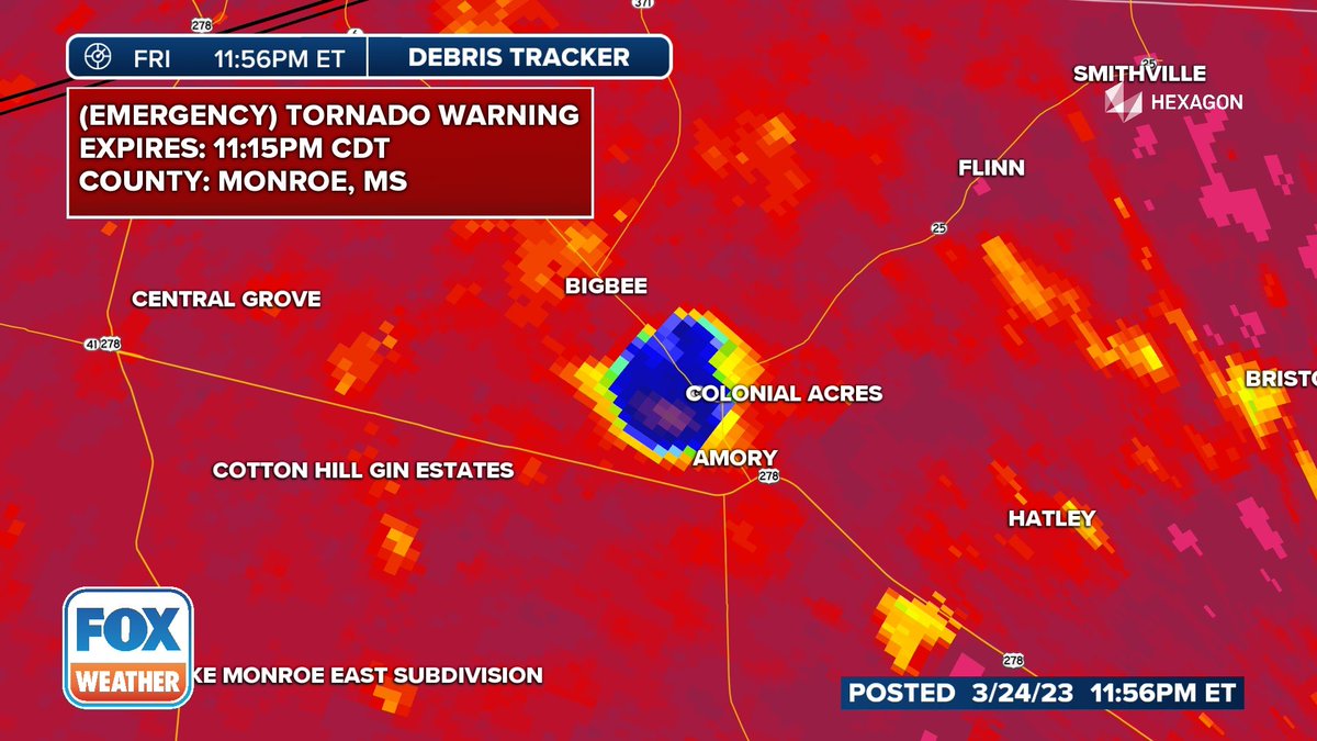
In my 20 years of meteorology, I’ve only had chills twice…4/27/11 and last night (3/24/23). The tornado that hit Monroe County, MS was jaw dropping. Pray for the entire state of #Mississippi #mswx #Tornado #TORNADOEMERGENCY
Wrestling legend Hulk Hogan has died at 71 years old 💔🕊️
This week, we want to introduce you to our team of meteorologists at the Alabama Weather Network. Today, meet Drew McCombs! Drew was born in Tuscaloosa and raised in the Birmingham area in northeast Jefferson County. He called Roebuck, Center Point, and Clay home during his…
San Francisco is experiencing one it's coolest summers (so far) in 60 years! And the forecast looks chilly for the rest! A strong marine layer, cool ocean temps, and no persistent high pressure are driving temps down! #CAwx #sanfrancisco


Well...this is the aftermath of today's thunderstorm in the North Valley...water got into the house, but we stopped it in time before it got too bad... @granttosterudwx @NWSAlbuquerque #NMwx
A timelapse showing 30 minutes worth of clouds flowing over Mt Adams and then Mt Washington after sunrise this morning (22 July 2025). #NHwx #NH #mountains #capcloud #timelapse
This Saranac Lake cam from @EarthCam is absolutely beautiful. And the temperature is even better! 35° on July 22! Their average low temperature is 51°. #nywx
Flash Flood Emergency for Fayette County, Illinois. 5-7" of rain has fallen and numerous reports of significant flooding. An additional 2" is possible. #ilwx #flooding
Sunrises over mountains and at 21K feet are simply pure bliss #NoFilter #ncwx

Was on an @AmericanAir flight from @JFKairport to @CLTAirport and the pilot actually flew under the anvil of a thunderstorm in Southern Virginia. 😍#vawx
Spending $7 on a bagel with crème cheese is highway robbery!
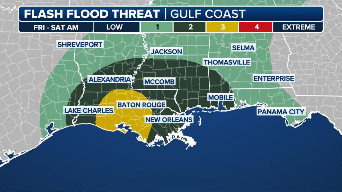
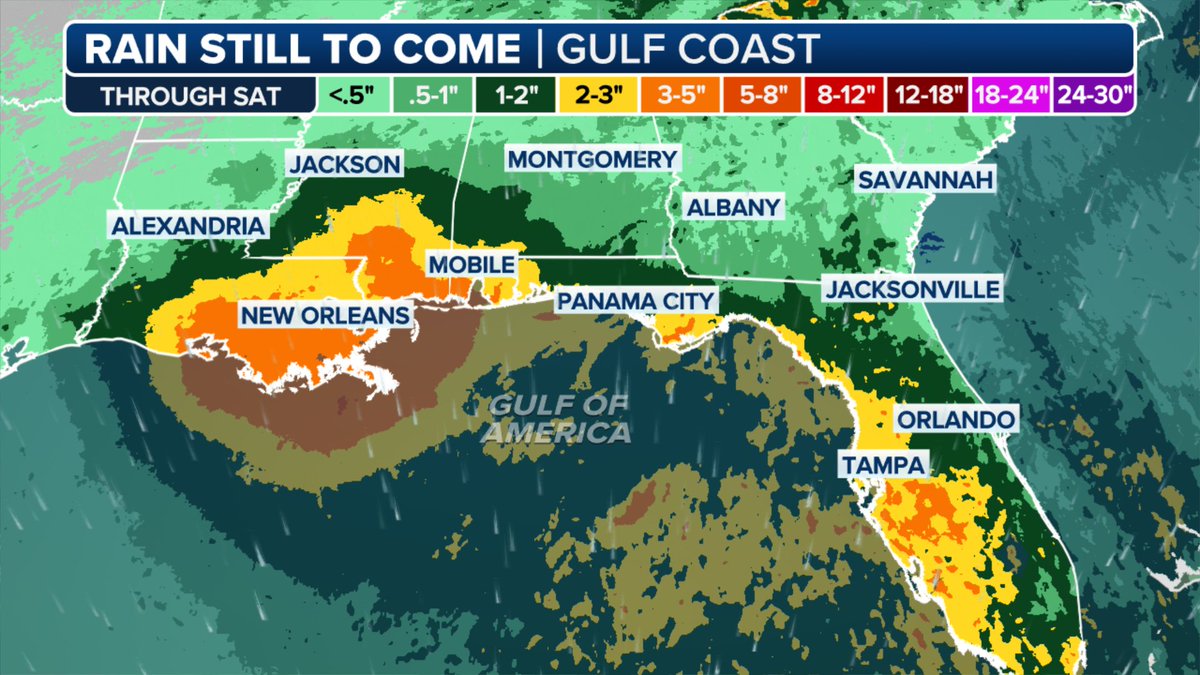
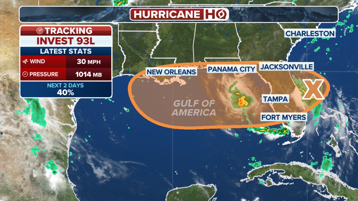
Invest 93L continues to get better organized with a medium chance of development; however, regardless of development flash flooding looks very likely all week but now especially Friday - Saturday morning for the Louisiana Gulf coast. #lawx #Invest93L #hurricanehq
NYC notched two new records yesterday. Broke a daily rain record of over 117 years and recorded the second wettest hour on record. #nycflooding #nywx @JaniceDean @NickGregoryFox5 @MathieuBlue
AKQ issues Flash Flood Emergency [flash flood: radar and gauge indicated, flash flood damage threat: catastrophic] for City of Colonial Heights, City of Petersburg [VA] till Jul 15, 2:15 AM EDT mesonet.agron.iastate.edu/vtec/f/2025-O-…
The @BNSFRailway Fire Train has arrived from Kansas with personnel focusing on extinguishing hotspots along the rail line. The Fire Train will make multiple passes through the fire perimeter to ensure dry vegetation is saturated.
New York City just experienced their second wettest hour on record 2.07" fell between 7-8PM. This is behind only the 3.47" that fell in one hour from the remnants of Ida No other event has seen the city record more than 2" in one hour
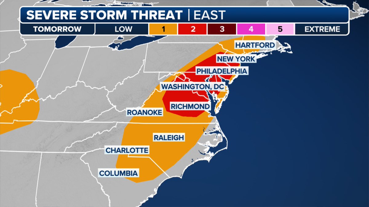
A MODERATE risk is in effect in our Day 1 Excessive Rainfall Outlook. More details: go.usa.gov/cu3Dw
Timelapses by USGS river cameras at the Rio Ruidoso River at Hollywood (L) and Otero/Lincoln line (R). The river quickly rises in just 10 minutes as a wall of water & debris flow downstream. #NewMexicoFloods #nmwx #flashfloodemergency @JaniceDean @CraigHerreraTV
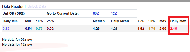
Near-record PWATs this morning in New York will support possible flooding this afternoon with rain rates up to 2"/hr. as a slow moving cold front moves through. Severe storms are also likely with damaging wind gusts especially in the afternoon. #nywx #njwx #pawx

The bats are out in South Texas. ZDR and RhoHV show differenting size targets (lower db values) depicting the bats leaving their caves.