
Payton Malone WWL-TV
@paytonmalonewx
@WWLTV Morning Meteorologist in New Orleans • University of Oklahoma • [email protected]
Invest 93 is unorganized. Low level center over Panhandle, but all the rain in the Gulf. We could still see a low spin up over the next 24-48 hours as it drifts along the Louisiana Coast. Regardless, expect tropical showers between Wed- Fri. There will be dry hours...maybe many.

I’m having Barry 2019 flashbacks. New Orleans got a lot of nothing thanks to northern shear and some dry air keeping rain on the southern side of the storm. It did cause problems and flooding in Western Louisiana though. This isn’t the same exact setup but it’s a reminder these…
Finally! After a blistering hot day, rain is moving in this evening! More passing showers will keep the heat less intense through the rest of the week. Thank the tropical disturbance moving through the Gulf.

Here we go again. Not surprising to see. We’ve been discussing this disturbance over the past few days. The NHC is giving it a low chance for development if it remains over the Gulf. It will bring passing showers along the northern Gulf Coast for the remainder of the week.…

I'm celebrating my win as Best Weathercast! Thanks to the Press Club of New Orleans for the award. Our city is home to many talented meteorologists, and I feel lucky to live and forecast here, where we can experience a hurricane and a snowstorm in the same year. Cheers and thank…

Déjà vu this week. Tropical moisture builds along the northern Gulf this week bringing a risk for heavy showers. Wednesday-Sunday are best chances for rain. Development doesn't look very likely at all. Wind shear likely keeps disturbance unorganized.

Tropical Update: Invest 93 remains mostly unorganized with rain. Showers will pass through Thursday and Friday with a risk for isolated flooding. But what happens after Invest 93 moves away? Well it looks like it could come back next week. Ya! for unwanted guests that come back…

A Street Flood Advisory has been issued for parts of Lafourche, Terrebonne until 7/17 5:00AM. Street flooding is possible in these areas. Don't drive through flooded roads. #BeOn4
A Severe Thunderstorm Warning has been issued for areas in Terrebonne, Lafourche, Assumption until 7/17 12:00AM. Seek shelter indoors until the storm has passed. #BeOn4
A Severe Thunderstorm Warning has been issued for areas in Hancock, St. Tammany until 7/16 7:30PM. Seek shelter indoors until the storm has passed. #BeOn4
Tropical showers will arrive this evening. If they hold together, they will probably bring 1-3 inches of rain over several hours with isolated higher totals. While widespread flooding is unlikely, street flooding is possible in typical areas with drainage or pump issues. This…

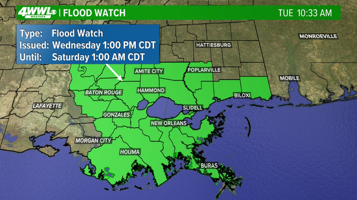
FLOOD WATCH issued for areas in green. Heavy rainfall could lead to flooding. #BeOn4
This is something we will watch closely on Wednesday. The old center will move inland and will likely dissipate. However, a new center could form in the Gulf if thunderstorms persist. Again, this will determine how strong the disturbance becomes. Fortunately, it doesn’t have…
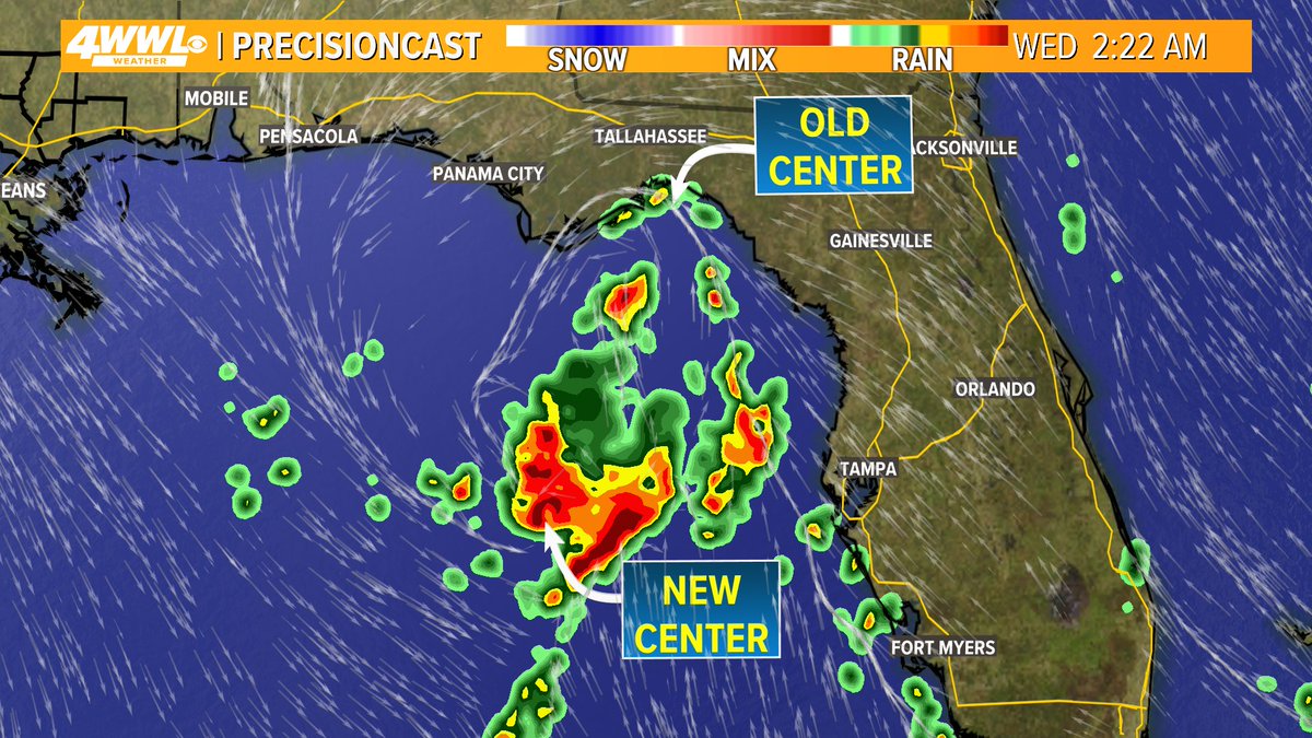
Invest 93 has a closed circulation and is moving into Florida Tuesday morning. It is expected to emerge into the Gulf tonight. What it does in the Gulf will determine how strong it becomes. If it stays near the coast, it will have less time over water to strengthen and will…

A Street Flood Advisory has been issued for parts of Orleans, Jefferson, St. Bernard until 7/14 6:45PM. Street flooding is possible in these areas. Don't drive through flooded roads. #BeOn4
A Street Flood Advisory has been issued for parts of Orleans, Jefferson, St. Bernard, Plaquemines, St. Charles until 7/14 3:45PM. Street flooding is possible in these areas. Don't drive through flooded roads. #BeOn4
Models might have some catching up to do 👀

A Street Flood Advisory has been issued for parts of Orleans until 7/13 5:15PM. Street flooding is possible in these areas. Don't drive through flooded roads. #BeOn4
A Street Flood Advisory has been issued for parts of Terrebonne, Lafourche, St. Charles, Jefferson until 7/13 4:45PM. Street flooding is possible in these areas. Don't drive through flooded roads. #BeOn4