SoCal Wildfire Tracker
@SkyzSmokey
Tracking wildfires across Southern California. In God we trust. In fires we track
#hughesfire video I shot leaving Castaic High School earlier, about a hour after the fire began.
🚨🚨TRAFFIC ALERT - NB AND SB SR-71 AT EUCLID AND EB SR-91 TO NB SR-71 IS SHUT DOWN AT THIS TIME DUE TO A BRUSH FIRE - AVOID AREA - USE ALT RTES - TRAFFIC IS STOPPED‼️ @chp_rancho
OES Intel 24 has Mapped the #EculidFire at 118 acres.
#MitchellFire 2 acres in the flats with a moderate ROS.
New start in #Anza Just popped up. No info at this time, looks to be moving pretty good though.


New start in #Anza Just popped up. No info at this time, looks to be moving pretty good though.

#EuclidFire @NBCLA Is going to be over the fire in the next couple of minutes and they have a live stream going nbclosangeles.com/news/local/bru…
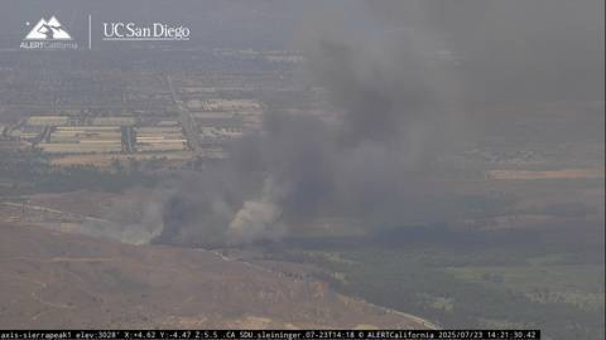
#EuclidFire now 100+ acres.
#EuclidFire air attack estimating 100-150 acres fire is pushing into the Prado dam
#EuclidFire The Fire is Pushing North and it will be impacting homes under construction in the next 20 minutes. Air Tanker 73, Copter 609, Helitanker 95HT is enroute.
#EuclidFire The Fire is 10-15 acres, Critical Rate of Spread, The Fire has a Potential for 500 acres, the Fire has Jumped Highway 71. Full Closure for HWY 71 has been Requested.
#EuclidFire is now 10-15 acres with a critical rate of spread on BOTH sides of SR 71. Potential for 500 acres.
#EuclidFire The fire is now 5 acres with a moderate rate of spread moving Southeast. Southbound lanes on SR 71 are going to be closed.
#EuclidFire The fire is now 5 acres with a moderate rate of spread moving Southeast. Southbound lanes on SR 71 are going to be closed.
[New Incident] Vegetation Fire reported in the area of Euclid Avenue x Highway 71, Chino Hills. @cvifd @CALFIRERRU @calfirebdu responding #EuclidFire
New start #EuclidFire West of the 71 Freeway within the 2020 Blue Ridge Fire scar. 1/4 an acre and topography driven with potential structure threats in the next 20 minutes.

Vehicle fire with spread into vegetation. The vegetation portion of the fire has Forward progress stopped.
@kerncountyfire Is en route to the 5 Freeway north of Fort Tejon for a reported vegetation fire with smoke showing on cameras.
#TrapFire Fire was mapped at 38.3 acres an hour ago. The Fire is holding within retardant lines. Most air resources are being released.


IC reports forward progress stopped, will update better acreage
In response to the #TrapFire in Mariposa County, the Red Cross is supporting a Temporary Evacuation Point at New Life Christian Fellowship (5089 Cole Road, Mariposa, CA 95338) for anyone impacted by the fire. For wildfire safety and evacuation tips, visit redcross.org/wildfire.
#AltaFire in Palermo, Butte Coounty The Fire is 30 acres with a slow rate of spread in grass with multiple structures threatened. An additional 2 Tankers and 5 additional engines have been requested.

#CanyonFire per Copter 19 the fire is 1/2 an acre moving uphill into a mulch field. Canceling fixed wing E/r from Sacramento. Should be able to handle in a short amount of time -Per radio traffic
New start #CanyonFire up Little Tujunga Canyon Road.