
Red Stick Ready
@RedStickReady
Welcome to the Red Stick Ready Twitter page. This channel provides Red Stick Ready’s mission-related information.
🚨BREAKING NEWS🚨 We’re proud to launch the brand-new Red Stick Ready Mobile App, designed to help YOU stay informed, build a disaster plan, and get real-time alerts before, during, and after the storm. ⬇️ DOWNLOAD NOW

🌀 A bit of Déjà vu as another weak area of low pressure rounds the high pressure and into the northern Gulf. ☔️ Aside from increased storm coverage and rainfall rates late this week, no significant impacts are anticipated from this system. 👉 Stay tuned to the latest forecast.
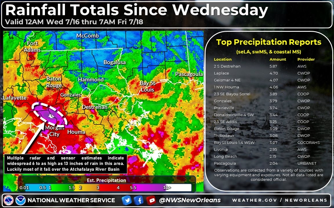
The Baton Rouge area recorded over 3” of rainfall this week. The sunshine and heat will return this weekend and heat index values could top 110°F by midweek. Stay hydrated and check on those vulnerable to heat sickness. #RedStickReady

Multiple rounds of storms associated with the tropical low will continue through the evening. Use caution on the evening commute: 🚘Plan for longer drive times. 🚘Do not drive around barricades placed for your safety. 🚘Avoid flood prone areas. #RedStickReady

High water has been reported at Highland/Julia. Please exercise extreme caution when traveling in the area. #redstickready

Ahead of the forecasted rainfall, City-Parish has stocked sand and sandbags at all nine self-service sandbag locations. Residents should bring their own shovel to fill sandbags. 📌 BREC Airline Highway Fairgrounds 📌 BREC Alsen Park 📌 BREC Baker Park 📌 BREC Cadillac Street 📌…


Odds have increased to a medium (40%) chance for tropical development in the northern Gulf over the next 7 days. Regardless of storm development, heavy rain is expected later this week. Stay connected to Red Stick Ready for ways to prepare and the latest information.…

A Severe Weather Warning has been issued for EBR. The main concern associated with this storm is damaging wind gusts. Use caution on the evening commute!

Stay #RedStickReady this 4th of July 🇺🇸🇺🇸 OUTDOOR ACTIVITIES ☀️🛥️👓 Always swim with a buddy and use U.S. Coast Guard-approved life safety jackets. Apply sunscreen with SPF 15 or higher and reapply every two hours or more often if you’re sweating. Stay hydrated by drinking plenty…

The Heat Advisory will continue tomorrow with the heat index increasing up to 112°. These temperatures can bring an elevated risk for heat-related illnesses. Protect yourself and your family from heat-related illnesses: 🚰 Increase water consumption. Drink plenty of fluids even…

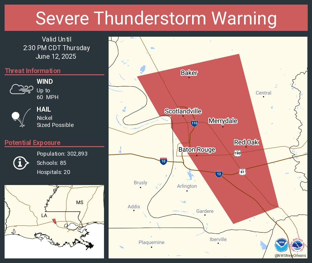
A Severe Thunderstorm Warning has been issued for the 2nd time this week! Stay alert on the evening communte and avoid problematic areas. #RedStickReady
A large area of thunderstorms continues to move through for southern areas. The main threats with these storms will be frequent lightning, gusty winds up to 40mph, and brief heavy downpours. We are also still seeing new storms pop up west of Baton Rouge. #lawx #mswx
Severe Thunderstorm Warning including Central LA, Denham Springs LA and Merrydale LA until 3:45 PM CDT
June is National Pet Preparedness Month!Make sure you’re prepared to keep both yourself and your pets safe! #PetPreparednessMonth

BATON ROUGE, LA- DOTD announces that both directions of I-110 near the Governor’s Mansion curve will close TONIGHT, May 30. The I-110 closure is expected to begin at 7:00pm, and the interstate will be closed between Capitol Access Rd. and N. 22nd St. wwwapps.dotd.la.gov/administration…
THIS JUST IN: NOAA announces the 2025 Atlantic Hurricane Season Outlook. Forecasters predict a 30% chance of a near-normal season, a 60% chance of an above-normal season, and a 10% chance of a below-normal season.

NWS has issued a Severe Thunderstorm Warning for areas of EBR until 11:30 AM.
