NWS New Orleans
@NWSNewOrleans
Official X account for the National Weather Service New Orleans. Details: https://www.weather.gov/nws_x
[4:20p 7/23/25] ⛈️ Isolated storms are popping up near the coast out ahead of a line of stronger storms coming across the MS Coast from the east. ⚠️ These storms are capable of winds in excess of 40-50 mph, high rainfall rates, and frequent lightning. 👉 Stay weather aware!
[8:15p 7/23/25] ⛈️ Showers and storms continue to spread westward through the New Orleans metro, but will gradually taper off by 10pm. ⚠️ These storms are producing heavy downpours, frequent lightning, and gusty winds upwards of 40-50mph. ⚡️ When thunder roars, go indoors!
An isolated strong storm is located between Covington and Robert, LA.
Special Weather Statement [wind: 50 MPH, hail: 0.00 IN] for Central Tangipahoa, Lower Tangipahoa, Northern St. Tammany, Southern Livingston, Southwestern St. Tammany, St. John The Baptist [LA] till 8:30 PM CDT mesonet.agron.iastate.edu/p.php?pid=2025…
[6:30p 7/23/25] ⛈️ The line of scattered storms is continuing west and will arrive into New Orleans and the Northshore in the next hour. ⚠️ The strongest storms within this line will be capable of causing street flooding, frequent lightning, and gusty winds up to 50 mph.
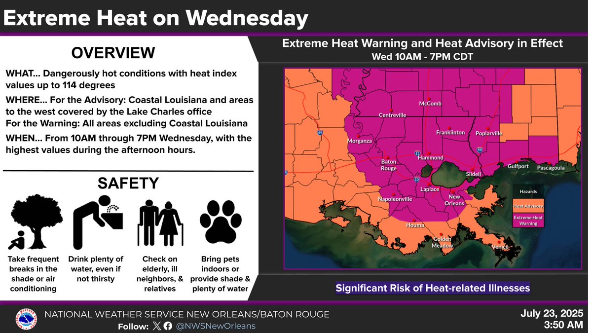
🔥 After several days of Heat Advisories, our first Extreme Heat Warning of the Summer is in effect today from 10AM to 7PM. Heat index values may reach up to 114°F. Compounding heat is especially dangerous. Stay cool, stay hydrated, and check on others. #LAwx #HeatSafety

🌀 A bit of Déjà vu as another weak area of low pressure rounds the high pressure and into the northern Gulf. ☔️ Aside from increased storm coverage and rainfall rates late this week, no significant impacts are anticipated from this system. 👉 Stay tuned to the latest forecast.

🥵 Another Heat Advisory is in effect today, and an Extreme Heat Watch is already up for Wednesday with heat index values up to 115°. Consecutive days of dangerous heat can take a serious toll on your body. Stay hydrated, take breaks, and check on others. #LAwx #MSwx


After a brief break in the heat courtesy of some higher rain chances this weekend, the last week of July looks to remain hot. #lawx #mswx

🌡️ Another day, another Heat Advisory. For the second day in a row, dangerous heat will grip the area. 🔥With more hot days likely ahead, heat stress can build up over time. Take breaks, stay hydrated, and check on others. #LAwx #MSwx

You know the drill. Here locally, when the rain tapers off, the heat builds! That is what we can expect going into mid-week with continued dangerous heat indices. But, rain chances return late-week, and that'll lower any risk for excessive heat. Stay safe if outdoors! #lawx #mswx

🥵 Heat Advisory today from 10AM–7PM. 🔥Dangerous heat with index values up to 112°F across most of SE LA & S MS (excluding the LA coast). ⚠️Stay cool, hydrated, and check on others! Pets need shade & water too. #LAwx #MSwx

Rain chances decrease on Sunday. Generally less than a 30 percent chance of rain during the afternoon hours. With lower rain chances temperatures will soar into the middle 90s for most locations. Take frequent breaks if you must be outdoors. #lawx #mswx
