
James Pettus
@PettusWX
I make cool stuff / Storm Chaser(ish) / Tropics, Aurora, and Snow lover / Helper for @MaxVelocityWX / Member of Team Dominator / Media Manager for @AtmosWX
Introducing PettusPlots! This is a big project I am working on that I am working to get out sometime this fall. Images displayed and generated in real time to provide advanced meteorological analysis and visualization. Coming soon -> pettusplots.com

We apologize for the delay in the release of Atmos. We are taking the time to revise, reimagine, and rework key components of our app to bring the user experience to the highest level possible Stay tuned for more regular development updates and sneak peaks about Atmos! #atmoswx
A Moderate Risk (level 3/4) of Excessive Rainfall is in effect through early Friday across parts of northeastern Kansas and northern Missouri. Numerous instances of flash flooding are possible and could result in locally significant impacts. Be sure to remain weather aware! ⛈️
Dangerous flooding possible in the Kansas City region and surrounds this evening. WPC mentioning widespread totals of 2"-3" likely, with isolated pockets of 4"-7" and very significant instances of 8"+ possible. As Jacob said, saturated soils from previous heavy rainfall events…
For the first time in over 4 years, a rare moderate risk for flash flooding now includes the Kansas City Metro for today/overnight. 🌧️ Grounds are already saturated, rivers remain high, and it will only take 2" to trigger a flash floods. Please be aware! @fox4kc #KCwx #MOwx #KSwx
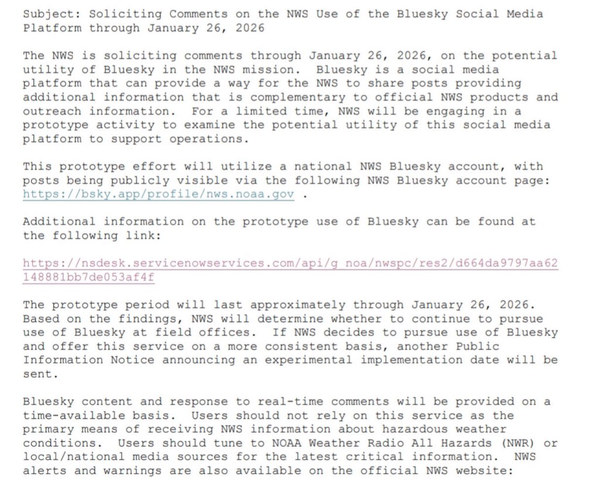
The NWS is set to start trying out Bluesky. More: weather.gov/media/notifica…
My mindset? Every day we are one day closer to 40s and cloudy with a slight flurry in the air with Christmas music on in the background.
The dog days of Summer will continue to be brutal through the end of July. But as we get several days into August, maybe we finally break the ridge & get some cooler air compared to average across the East? I think the Northeast is nearly a lock for this, but hopefully we can…
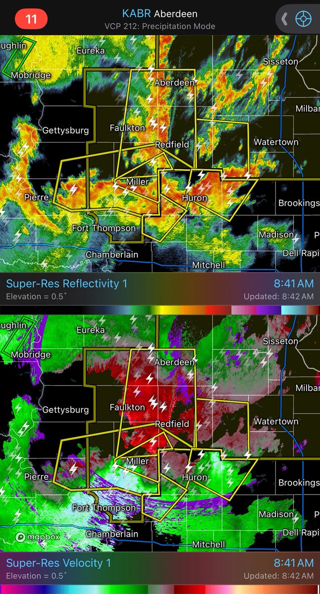
Destructive severe thunderstorms are moving through South Dakota this morning. Seek proper shelter if you are in these areas.
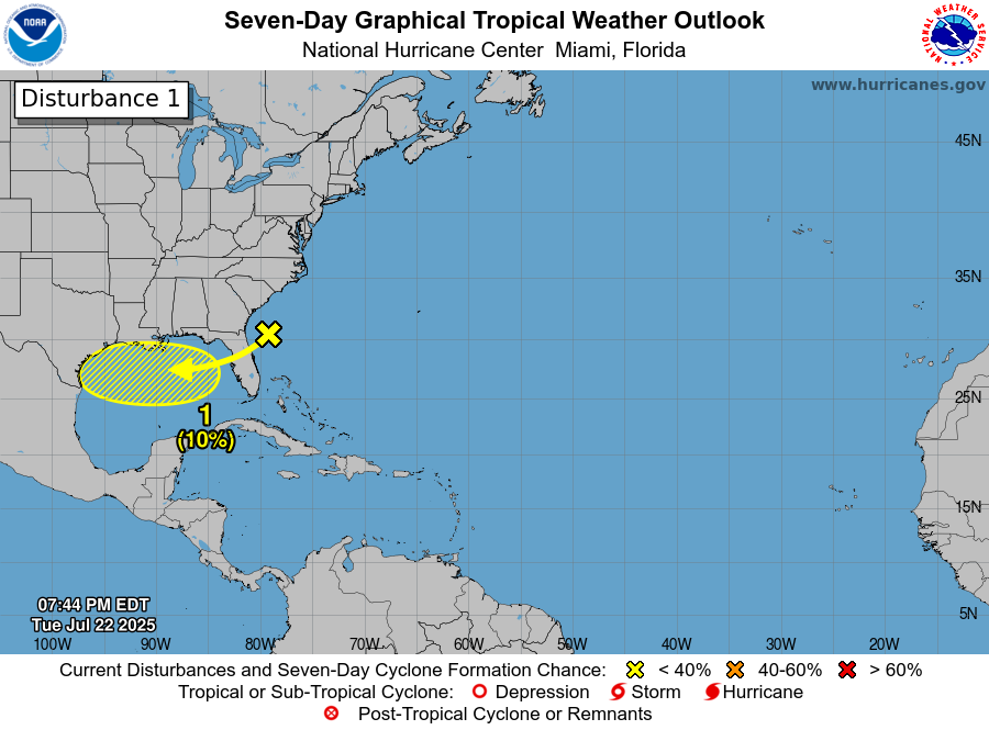
Monitoring the gulf for some maybeee tropical activity. Monitoring.

why has no one informed me of how satisfying slow mo windshield wipers in rain are
Intercepting this severe warned storm south of Nashville. Not tooo impressive in the Forest Hills area.


👀🌀
Introducing PettusPlots! This is a big project I am working on that I am working to get out sometime this fall. Images displayed and generated in real time to provide advanced meteorological analysis and visualization. Coming soon -> pettusplots.com
FLASH FLOOD EMERGENCY for Brownstown, Illinois! EXTREMELY DANGEROUS SITUATION evolving here, as 5-6" of rain has fallen, and 2-3"+ more is coming. Get to higher ground NOW!