
Pete Bouchard
@PeteNBCBoston
Chief Meteorologist NBC10 Boston #meteorologist in Boston since 373ppm (2002). PT sawdust maker and guitar hack. Califormonter. IG: @petenbcboston
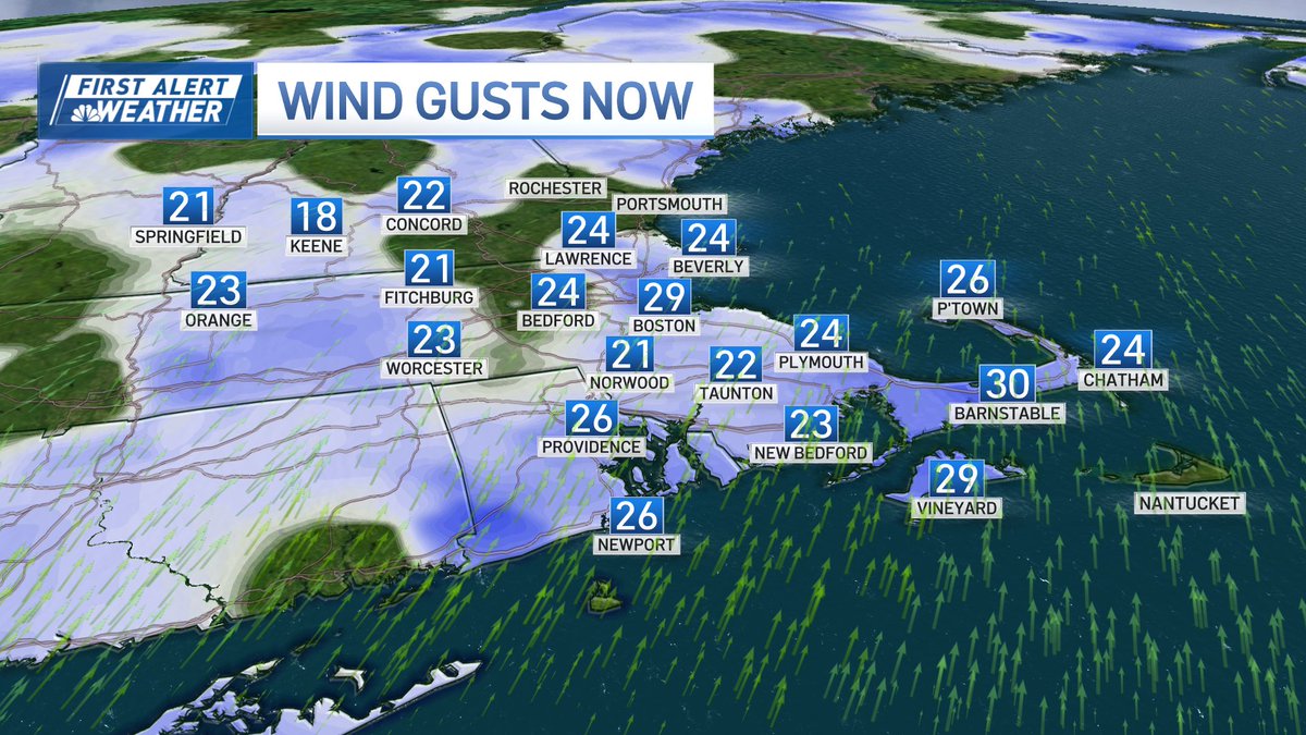
At least the air isn't still. Some gusts topping 30mph on this hot afternoon.
A trio of nasties dropping down from NH to MA. Heavy rain & occ. lightning into Ashby, Townsend, & Pepperell over next hour.
Yeah, the focus is on the heat late this week, but the signal for cooler than normal weather is strong after the middle of next week. 👀 (Darker shadings of blue = higher confidence.)

😥
BREAKING: Ozzy Osbourne, the Black Sabbath singer who rose to heavy metal stardom, has died at age 76, his family says. nbcnews.com/news/obituarie…
According to CSU, our avg chance for impact from a hurricane is around 14% any given year. Important to stress that although we've been in a "hurricane drought", the chances aren't accumulative. Avg. odds don't change because we haven't had a landfalling hurricane in 34 years.
Pete what are odds for a large hurricane hitting us? It’s been like 40 years man
Storms just strengthened as they approach the coast. Beware of gusty winds and possible hail in these cells.
Six Tornado Warnings yesterday in northern Maine. In contrast, it's been 366 days since our last Tornado Warning in southern New England.


Dpwnpours - and a remote chance at thunder - rolling through the Merrimack Valley & the Seacoast in the next hour. The caboose should clip Fitchburg & Leominster.

The dew point (humidity) drop is dramatic. By mid-morning tomorrow, we'll be in a much more refreshing airmass.
Brief storm flare up early this AM in Maine. As it dissipates, the "last gasp" downdraft ripples through the lower deck of clouds. #coolscience
Storm progressing south...arrival times shown. Still a threat for heavy rain, strong wind, and occasional lightning. Tornado threat diminished.

Still no tightening of this rotation. Storm moving south towards Shirley & Ayer & Harvard.
Red/green what does it mean? Possible rotation in this now severe storm. It’s broad (wide) so NOT a promise for a tornado.

Heat wave in northern Alaska: up to 34°C (93°F) on Saturday at a site near Kobuk in the northwestern interior. Back down to -1°C (30°F) yesterday morning.

4.57 as of 9am...2 this morning and additional 2.57 around 9am Pete CoCorahs gauge
Here’s the proof that the worst is over. On the other end of the spectrum, beneficial rain falling to the north thru southern NH.
Flooding on the South Shore this morning. Deluge just about done as the heaviest rain scoots offshore.

Storms/downpours still holding together. Meantime, the next wave of heavy rain waits to pounce late tonight/early tomorrow AM. Locally heavier amounts could approach 2-3".

