
NW Ohio Wx
@NWOhioWeather
Williams, Fulton, Lucas, Ottawa, Defiance, Henry, Wood, Sandusky, Paulding, Putnam, Hancock, Seneca, Van Wert, Allen, Mercer, Auglaize, Hardin, and Wyandot.
Severe Thunderstorm Warning including Union City IN, Union City OH and Fort Recovery OH until 8:45 PM EDT
While scattered showers continue, diminishing trend will be noted during the next couple of hours. #OHwx

#WPC_MD 0806 affecting central Illinois, northern/central Indiana, western/northern Ohio, far northeastern Missouri, #ohwx #inwx #ilwx #mowx, wpc.ncep.noaa.gov/metwatch/metwa…
Storms rolling into Deshler. View courtesy of .@virtual_railfan. #OHwx .@NWSIWX

Scattered storms by Sunday afternoon. Highs in the middle 80s. Partly cloudy Sunday night. Middle 70s for lows. #OHwx

Severe storm crossing into Paulding and Van Wert County. 60 MPH wind primary hazard. Some rotation noted on radar. #OHwx


#WPC_MD 0805 affecting eastern IL into northern IN/southern MI and northwestern OH, #miwx #ohwx #inwx #ilwx, wpc.ncep.noaa.gov/metwatch/metwa…
Few scattered showers this morning. Shower/storm chances increase through today. Locally heavy rainfall possible. #OHwx

Severe storm east of Lima moving northeast. Quarter size hail and 60 MPH wind. #OHwx


IWX issues Severe Thunderstorm Watch for Fulton, Williams [OH] till Jul 25, 12:00 AM EDT mesonet.agron.iastate.edu/vtec/f/2025-O-…
CLE issues Severe Thunderstorm Watch (7 areas) till Jul 25, 12:00 AM EDT mesonet.agron.iastate.edu/vtec/f/2025-O-…
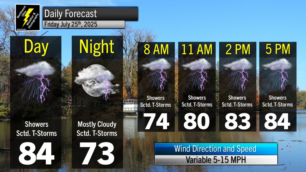
Thunderstorm chances continue Friday into Friday Night. Highs in the middle 80s. Lows in the middle 70s. #OHwx

Current Temp/Dewpoint/Heat Index: Van Wert 91/73/101 Defiance 90/76/102 Wauseon 89/77/103 Ottawa 89/81/108 Lima 88/76/99 Wapak/New Knoxville 87/75/98 Toledo 91/75/102 Findlay 89/76/100 Kenton 88/77/100 Port Clinton 86/75/95 Fremont 90/81/108 #OHwx
Storms possibly later today into this evening will pose risk for strong to damaging wind. #OHwx
