NWS Wilmington OH
@NWSILN
Official Twitter Account for National Weather Service Wilmington OH. Details: http://weather.gov/twitter
Flash Flood Warning including Lancaster OH, Pickerington OH and Baltimore OH until 7:00 PM EDT

[245 pm 7/27/25] Numerous showers and thunderstorms are moving across the region. These are occurring in a very moist atmosphere which is resulting in some intense rain rates. Flooding is already occurring in some places. If you experience flooding, turn around, don't drown.
Flash Flood Warning including Pickerington OH, Baltimore OH and Millersport OH until 5:30 PM EDT

Flash Flood Warning including Anna OH, Jackson Center OH and Botkins OH until 4:00 PM EDT

[5:00 AM] Here we go again... Above average temperatures with showers and thunderstorms moving through. The environment is very moist, so storms will likely produce heavy rainfall, leading to localized flooding problems! An isolated strong storm is possible with damaging winds.
![NWSILN's tweet image. [5:00 AM] Here we go again...
Above average temperatures with showers and thunderstorms moving through. The environment is very moist, so storms will likely produce heavy rainfall, leading to localized flooding problems! An isolated strong storm is possible with damaging winds.](https://pbs.twimg.com/media/Gw2jJMNWYAAHv-F.jpg)
Have you experienced flooding or storm damage tonight? Please share your damage/flooding when you can safely do so. To help us verify, PLEASE include a street intersection close to your damage!!
Flooding has closed roads in Franklin and Fairfield counties following heavy rains in central Ohio. 10tv.com/article/news/l…
Flash Flood Warning including Lancaster OH, Bremen OH and Amanda OH until 12:00 AM EDT

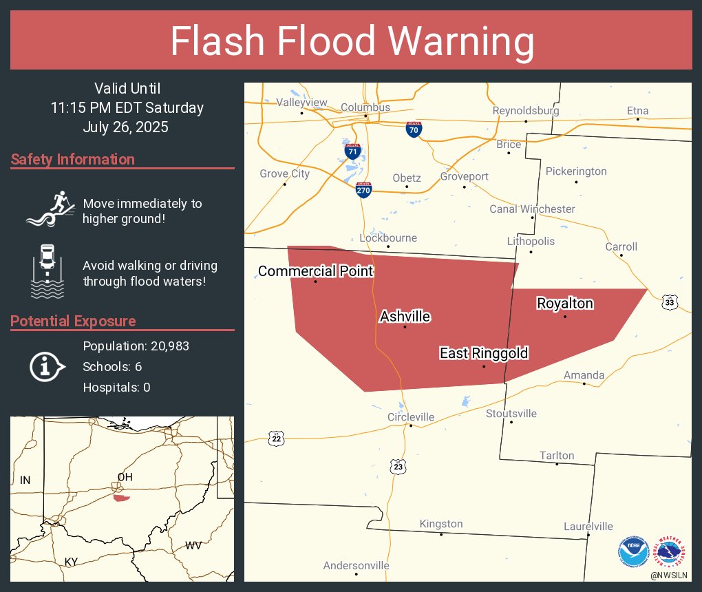
Flash Flood Warning including Ashville OH, South Bloomfield OH and Commercial Point OH until 11:15 PM EDT
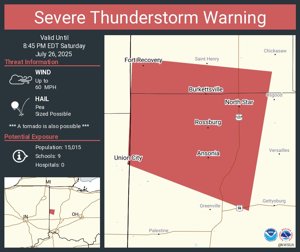
Severe Thunderstorm Warning including Union City IN, Union City OH and Fort Recovery OH until 8:45 PM EDT
[8:10 PM] Persistent thunderstorms in the Columbus area are putting down very heavy rainfall. Some rain gauges across southeast Franklin and northwest Fairfield Counties are approaching 3 inches of rain. Remember, do not drive through flooded roadways.
Flash Flood Warning including Pickerington OH, Canal Winchester OH and Groveport OH until 11:00 PM EDT

Showers and a few thunderstorms have been sprouting over the region early this afternoon. Expect this activity to increase over the next few hours.
[5:30 AM] Another day of above average temperatures combined with scattered afternoon thunderstorms. Some storms may produce locally heavy rainfall, leading to quick runoff or flooding as well as gusty winds.
![NWSILN's tweet image. [5:30 AM] Another day of above average temperatures combined with scattered afternoon thunderstorms. Some storms may produce locally heavy rainfall, leading to quick runoff or flooding as well as gusty winds.](https://pbs.twimg.com/media/Gwxh5CuXYAEFx_M.jpg)
Storm coverage and intensity decreasing throughout the area. There may be some localized flooding issues in portions of Licking County, OH with the repeated rounds of torrential rainfall. Otherwise, we will continue to observe decreasing shower/storm chances this evening.
Severe Thunderstorm Warning including Hilliard OH, London OH and West Jefferson OH until 6:30 PM EDT

Tornado Warning including Springfield OH until 6:00 PM EDT

Severe Thunderstorm Warning including Springfield OH, Yellow Springs OH and Enon OH until 6:00 PM EDT

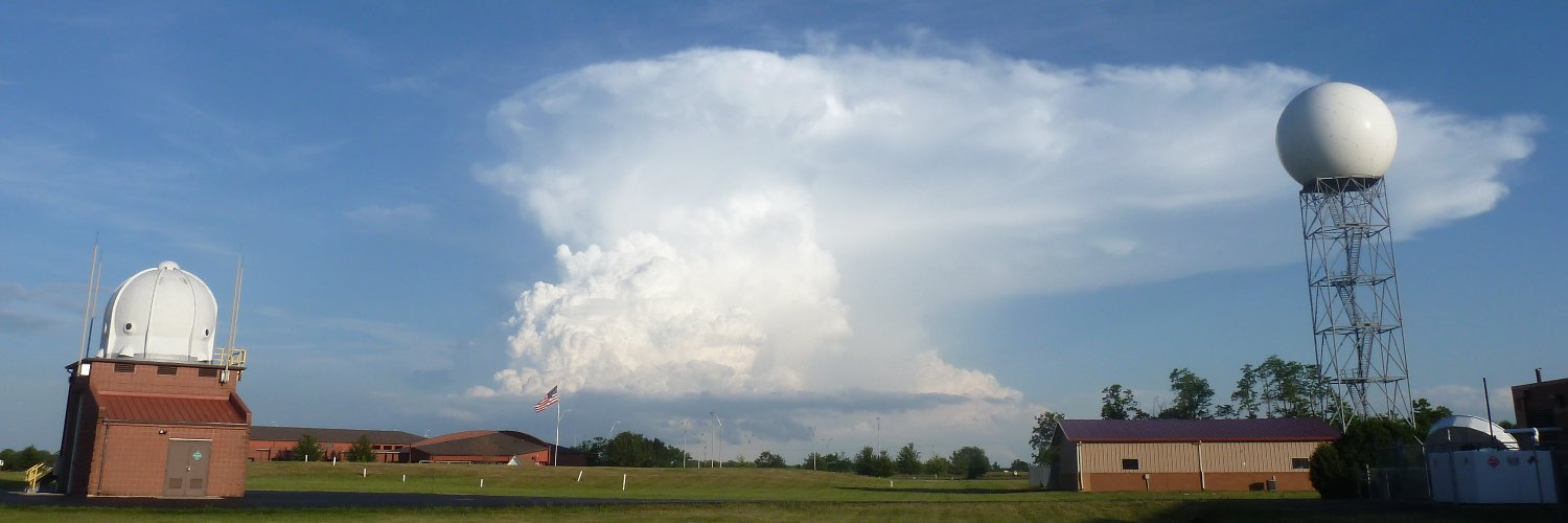
[430 pm 7/25/25] Showers and storms have become more numerous in west central Ohio and the northern Miami Valley. Areas along and north of I-70 will remain favorable for strong to severe storms over the next few hours.
![NWSILN's tweet image. [430 pm 7/25/25] Showers and storms have become more numerous in west central Ohio and the northern Miami Valley. Areas along and north of I-70 will remain favorable for strong to severe storms over the next few hours.](https://pbs.twimg.com/media/GwuvfqCWIAAj_TF.jpg)
Severe Thunderstorm Warning including Troy OH, Union OH and West Milton OH until 4:45 PM EDT

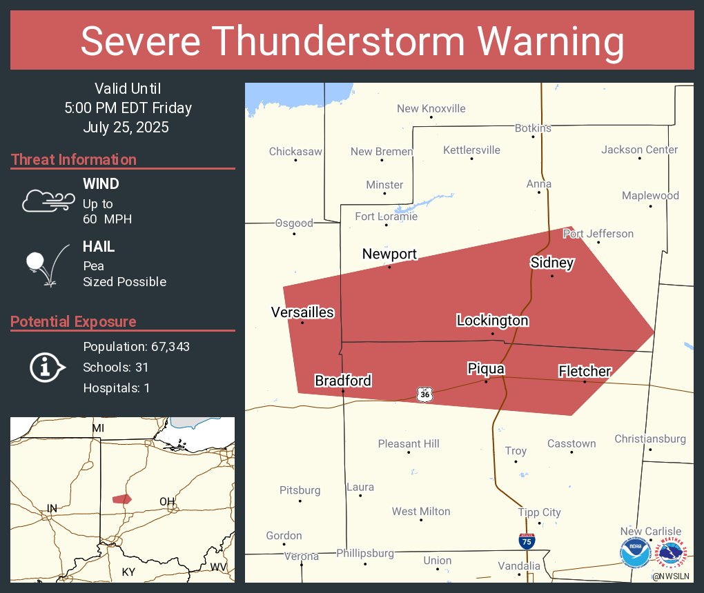
Severe Thunderstorm Warning including Sidney OH, Piqua OH and Versailles OH until 5:00 PM EDT