David Wolter
@DavidWolter1
Chief Meteorologist @wbkotv | @nwas seal | 🎓@RoanokeCollege @msstate | Once played comedian @tomsegura in basketball 🏀 | Tweets/re-tweets are mine.
RADAR UPDATE: Scattered showers and storms are developing from Russellville to BG and Glasgow. Some locally heavy rainfall is likely with storms today

RADR UPDATE (1:40 PM): Scattered heavy showers and storms are developing this afternoon. Some isolated flooding and frequent lightning is possible.

The heat index will likely be between 100 and 105 for most of Wednesday afternoon. #kywx

If you are heading to the coast for an end of summer trip before the kids head back to school, GOOD NEWS, no tropical systems are expected to develop over the week.

2 MONTHS AWAY! It won't be long before those pumpkin spice lattes are calling your name.

A Heat Advisory will go into effect tomorrow afternoon and continue into the early evening. The feel-like temperature could be as high as 105.

This season officially runs from now until early September....

The blank stares from players and fans said it all. The thing about Ozzy is that you could never claim he wasn't being himself. 🤣
Never forget Ozzy Osbourne's iconic 7th inning stretch at Wrigley back in 2003 ❤️
Another storm with heavy rain and gusty winds is moving into Bowling Green from the northwest. Here is the shelf cloud moving over the city.

RADAR UPDATE (3:46 PM): Storms with heavy rain continue to advance into Edmonson and Warren counties. Wind gusts up to 40 mph possible.

Some very heavy rain and gusty winds continue to spread across the area! LIVE RADAR: WBKO.com/weather/radar

Severe Thunderstorm Warning for Hopkins, Muhlenberg, Christian, McLean Co. until Jul 19 4:30PM. Check WBKO.com, WBKO-TV, and WBKO social media for more details. @WBKOWeather @wbkotv #wbkowx #kywx
Tarp is off the field and we’re ready to rock! First pitch scheduled for 8 PM. #RevItUp | #Leg4cy
Flash Flood Warning for Warren, Logan, Simpson Co. until Jul 18 9:30PM. Flooding is occurring or is imminent! Check WBKO.com and WBKO-TV for more details. @WBKOWeather @DavidWolter1 @wbkotv #wbkowx #kywx
New Flood Advisory issued for northern Logan, southern Butler, and far western Warren county until 9 pm. #kywx

RADAR UPDATE (5:38 PM): Heavy showers and storms are situated across Logan and Butler counties. Isolated flooding possible with these downpours. TRACK STORMS LIVE: wbko.com/weather/radar/

RADAR UPDATE (3 PM): Lots of lightning with a storm over western Monroe county this afternoon. Also watching some heavy areas of rain in Hart, Allen, and southern Barren counties. Scattered downpours and gusty winds are expected with storms through the end of the afternoon.

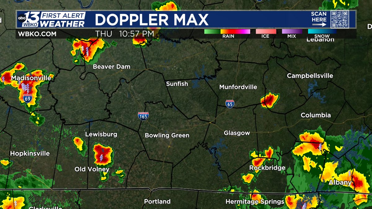
RADAR UPDATE (10:56 PM): Still watching scattered storms that could produce heavy rainfall during early overnight period. Wind gusts up to 40 mph are possible on a few storms.
The super high humidity levels across parts of the Midwest next week will be the result of corn......sweating! Feel-like temperatures in states like Iowa and Illinois could be over 110! #CornSweat 🌽

RADAR UPDATE (9:01 PM): We have a heavier storm south of Glasgow, extending down to Fountain Run producing some very heavy rainfall.
