Hunter Anderson
@ColdCoreCowboy
Lilapsophile who enjoys isoplething & analoging. Meteorologist | SCSU AHS | Job 36:26-30 | Married to K
Normally don't do a post like this, but wanted to say happy 27th birthday to my (Twitterless) wife, Kristin.☺️ WAIT, did I mention we got married?! This was back on Sept 14th...😅 I want to prioritize my marriage, so I'll remain less active on SM. Much love to you all🙏💙


Just like the Casino, MN tornado (which formed in a similar MCV-driven environment) from 6/16/25, these tornadoes appear more "violent" than the damage they incur. The upward vertical motions in the FC are truly impressive, in contrast to its tangential velocities. #wiwx
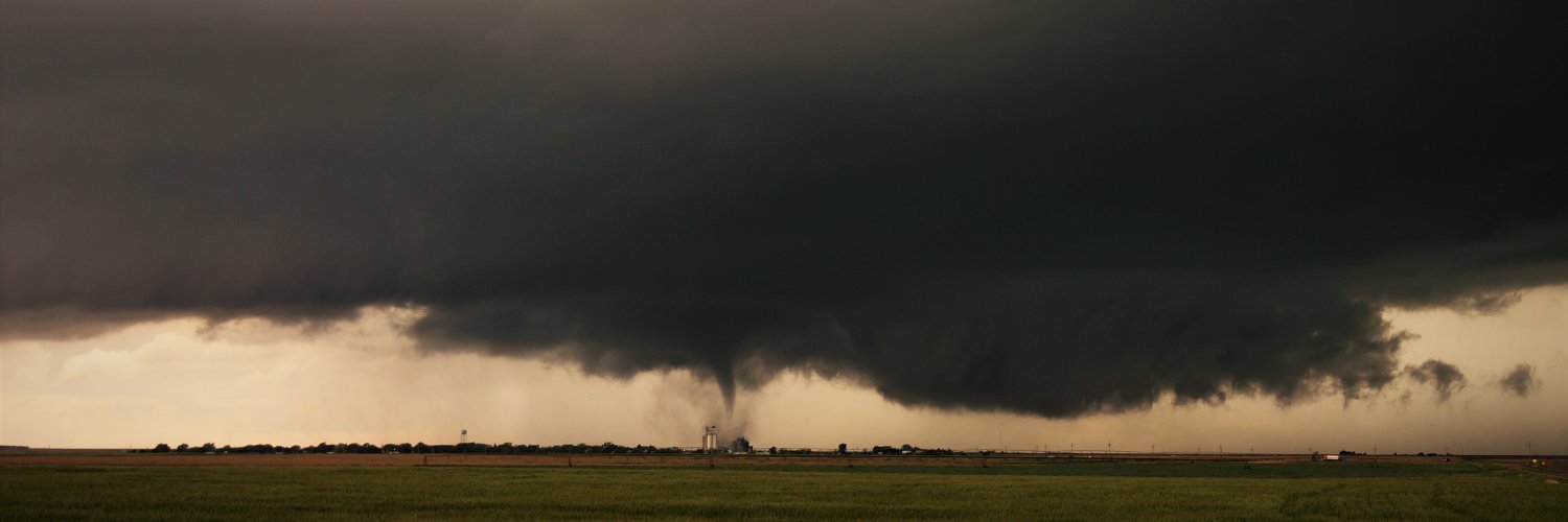
VIOLENT TORNADO PRAIRIE DU SAC, WISCONSIN @NWSMilwaukee
The classic 20% chance of rain but it's impacting 100,000+ people. Also, I can't believe cell phones can take photos like this with little effort. Technology has come a long way. #mnwx


Lapse rates are not above 8, & surprisingly enough, this storm isn't that great! #iawx
2322Z - 2mi SW of Swaledale, IA looking N at TOR. Non-rotating wall cloud feature. Crisp rising Cb column above. Plenty of scud at base, but "bark is worse than its bite". @NWSDesMoines #iawx
x.com/Nick_LaLonde15… The wall cloud feature I referenced in this report (Mr. LaLonde is sitting next to me)
2105Z - Rockwell, IA looking SW. The updraft continues to battle dry mid-level air. Low-level Cu field is expanding around the cell however. Updraft base in distant view, which has now is exhibiting a wall cloud structure. #iawx
"Lapse rates above 8, storms are great!" #mnwx #ndwx x.com/ColdCoreCowboy…
The tornado west of Beltrami, Minnesota yesterday evening. #mnwx
This is not true. NWS offices are NOT overstaffed. Every NWS office in the country has several unfilled positions. What she is probably referring to is that staff who were off work were brought in on overtime to aid in the response to active weather, because they're dedicated.
Leavitt: "There were record-breaking lead times in the lead up to this catastrophe ... in fact, one of the offices was actually overstaffed. They had more people than they need."
Shamelessly posting @hinto62's epic shot when I think it was most akin to Oakfield. Sent this same comparison to many others earlier today. Takes a very particular (& temporally rare) environment to support this. 1 in 20? 25? 30 year event?!
Many have compared yesterday's Gary, SD tornado to Ashby 2020. But there was a phase where it looked almost exactly like the Oakfield tornado of 1996.
You never wanna say it, but we're gonna say it right now: "Lapse rates above 8, storms are great. Lapse rates above 9, storms are divine." (In hindsight, aside from the robust EML, the modeled VWP is essentially a more compact version of the VWP during Ashby EF4 event). #sdwx
However, model soundings over W. MN keep upper flow weak & veered. Streamwise sub-1km SR flow should still favor periodic strong low-level mesocyclones, assuming isolated storm mode. Best chance for tornadoes will be early, but could contend with "HP" modes. Lapse rates >8C! 7/9
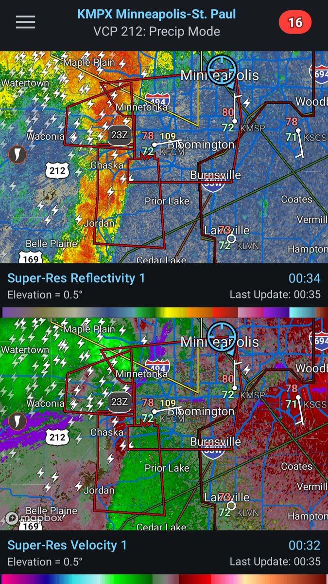
N-S oriented squall line approaching MSP has absorbed an outflow boundary from the W-E segment of storms north of the metro. 42 kts of largely line-normal 0-3km shear. Already multiple radar-confirmed tornadoes near Waconia-Chanhassen. Sirens are blaring in downtown. #mnwx

If you want to see an incisive thread age like milk, look no further. My theory has gone completely out the door. Perhaps "all you need" is extreme MLCAPE axis extending into a vorticity-rich boundary & a storm with long residence time on said boundary. x.com/ColdCoreCowboy…
Long lived violent tornado east of Clear Lake, SD during various stages of its lifecycle. Could hear the violent roar of this tornado as it ripped apart the trees in the first photo. @SimonStormRider, @AaronRigsbyOSC, and I said today looked like Ashby 2.0, and it delivered!! The…