
Ben Beddoes
@BenWKYT
Weekend Meteorologist/Reporter at WKYT in Lexington, KY. VA Native. Hokies and UK Wildcats fan. Opinions are my own.
Another day, another hot afternoon as temperatures are in the low 90s, feeling more like the upper 90s to low 100s. A few showers and storms are possible as we head into the evening, especially north.


There it is! Today is the hottest day you have ever experienced in Tampa. 100° - for the first time on record in #Tampa (records go back to 1890) @NWSTampaBay
More of the same is expected for Sunday. Highs around 90, feeling more like 100 degrees, with more scattered afternoon and evening storms.


A special weather statement has been issued for Morehead KY, Owingsville KY and Farmers KY until 7:45 PM EDT
5-second hyperlapse video of #Saturday evening storm passing through Fayette County into Bourbon, and Nicholas counties. Video by: #AirDroneOne. @BenWKYT @thekyniche @cjwxguy56 @jsmithwx @jloganwxguy @NWSLouisville @AlexaMintonWX @PaydenHinkle
Some of us got a rain shower, some only a few drops, some zero rain, and someone got a thundershower today. Do you see the rain showers over Bourbon County this late #Saturday afternoon? Photo by #AirDroneOne.
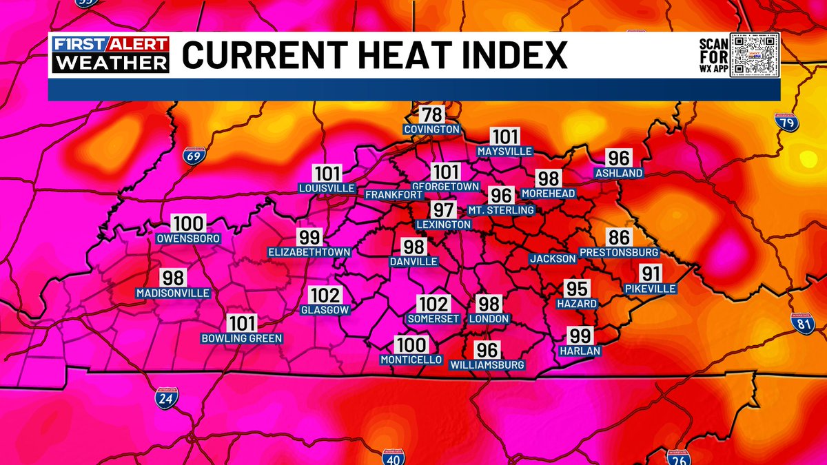
Heat Advisories now include central Kentucky and areas north and west. Heat indices are expected to reach 100-105 degrees every day through Wednesday.


I thought this cloud formation with the hole and blue skies were really cool! #Saturday afternoon in central #Kentucky and it's 'hot'! Photo by: #AirDroneOne. There's an increased chance you might get your head wet today.
A hot and steamy Saturday is in store for us with scattered showers and storms for the late afternoon and early evening. Highs will be around 90, feeling like the upper 90s to around 100 degrees.


A Heat Advisory will remain in effect through the weekend in areas north and west of Lexington. Heat indices will be in the upper 90s to low 100s during the hottest points of the day this weekend.


Hyperlapse drone video of cloud development #Friday afternoon in #Lexington. Could we get a storm? Video by: #AirDroneOne. @GaudetWeather @jloganwxguy @NWSLouisville @thekyniche @cjwxguy56 @Kentuckyweather @BenWKYT @AlexaMintonWX @jsmithwx @PaydenHinkle
It will be a hot and steamy Friday and weekend ahead as heat indices top out around 100 degrees. We will crank the heat up even more come Monday and Tuesday when heat indices push 105 degrees.

An updated Day 3-7 Hazards Outlook has been issued. wpc.ncep.noaa.gov/threats/threat…
There is a rain shower over east #Lexington this early #Thursday evening. Photo by: #AirDroneOne.
Heat Advisories have expanded to a few more counties and now include areas north and west of Lexington through Friday evening. Heat indices will top out on either side of 100 degrees on Friday.


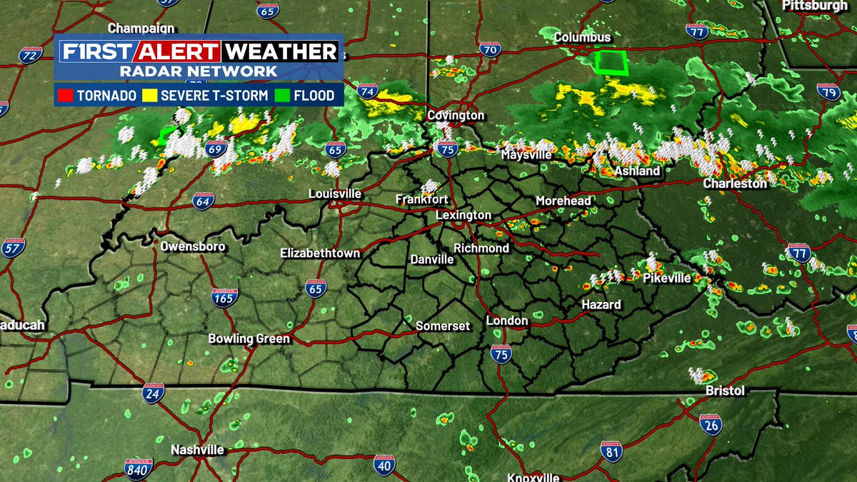
Flash Flood Warning for parts of Knott and Floyd counties until 8:15 PM. #kywx
Morgan County sheriff showing flash flooding ongoing in West Liberty, KY
#WPC_MD 0769 affecting Northern and Eastern KY...Southwest VA...Southern WV, #wvwx #vawx #ncwx #tnwx #kywx #ohwx #inwx, wpc.ncep.noaa.gov/metwatch/metwa…
In creditable light show #Sunday night in central and northern #Kentucky. Vidoe by: #AirDroneOne. @cjwxguy56 @Kentuckyweather @jloganwxguy @thekyniche @jsmithwx @NWSLouisville @BenWKYT @AlexaMintonWX @GaudetWeather
We have one more day with a threat of flash flooding. Again for Monday, one or two storms could be on the strong to severe side with damaging winds the main threat. A Flood Watch is out for the area until Monday evening.


