
Sara Kress
@sarakresswx
Meteorologist @KDRV | tOSU alum
Highs will be a few degrees cooler today, but it won't be helping much. If you're heading out to the Jackson County Fair later today, plan for the heat! Westside areas remain under a HEAT ADVISORY until 8 PM tomorrow.


STORMTRACKER 12: A FLOOD ADVISORY has been issued for southern Klamath County, including southern Klamath Falls and Falcon Heights, until 11:30 PM. 1-2" of rain has already fallen and with more expected, urban and small stream flooding is expected.
A FLOOD ADVISORY has been issued for central Siskiyou County, including mainly rural areas along Dunzel Creek (in the green outlined area), until 9:30 PM. Minor flooding is ongoing or expected to begin shortly in the advisory area.

A FLOOD ADVISORY has been issued for central Siskiyou County including Yreka, until 9:15 PM. Heavy rain due to thunderstorms will cause urban and small stream flooding.

A SEVERE THUNDERSTORM WARNING has been issued in Central Siskiyou County, including Yreka, Fort Jones, and Greenview, until 6:45 PM. This storm is capable of 60 mph wind gusts a quarter size hail. This storm is moving southwest at 15 MPH.

A lot of heavy rain and strong winds with this storm in Yreka. Severe Thunderstorm Warning continues until 6:15 PM. Be sure to download our StormTracker 12 weather app to track storms with the interactive radar and get any severe weather alerts for your location.
A SEVERE THUNDERSTORM WARNING has been issued in Central Siskiyou County, including Yreka, Montague, and Grenada, until 6:15 PM. This storm is capable of 60 mph wind gusts a quarter size hail. This storm is nearly stationary.

Here's the view from our Klamath Falls cam looking at that severe thunderstorm to the south near Dorris. This storm is capable of 60 mph wind gusts and quarter size hail right now. We aren't seeing much movement on the storm either. #StormTracker12
A SEVERE THUNDERSTORM WARNING has been issued in northeastern Siskiyou County and south central Klamath County, including Dorris and Worden, until 5:15 PM. This storm is capable of 60 mph wind gusts and quarter size hail. This storm is moving south at 10 mph.

SA SEVERE THUNDERSTORM WARNING has been issued in far southeast Siskiyou County until 4:30 PM. This storm is capable of 60 mph wind gusts a quarter size hail. This storm is moving southeast at 20 mph.
Isolated thunderstorm chances are in the forecast today, but we have a close eye on tomorrow. We're expecting storms to be more numerous and widespread with severe storms possible. A FIRE WEATHER WATCH has been issued for areas where new fire starts are likely on Thursday.

If you missed us this morning, don’t worry! Samantha and I are back tonight at the fair 🎡 Check us out on-air at 6 p.m.

Level 2 (BE SET) Evacuation at the Board Shanty Fire is now in place for zone JCU-448-A. More information can be found here ---> kdrv.com/news/firewatch…

Here's a morning look at the Board Shanty Fire in Josephine County, now standing near 340 acres.


JAC-068 has been added to a Level 1 (Be Ready) Evacuation.
JUST IN: A Level 2 (Be Set) Evacuation has been issued for zone JCU-437 in addition to JCU-436 for the Board Shanty Fire southeast of Grants Pass in Josephine County. The fire is estimated to be up to 50-70 acres. More details on this fire on KDRV.com
Elk Fire Evacuation Zones KLA-1737 and KLA-1741 have been downgraded to Level 1 (BE READY). More information can be found HERE ---> kdrv.com/news/top-stori…

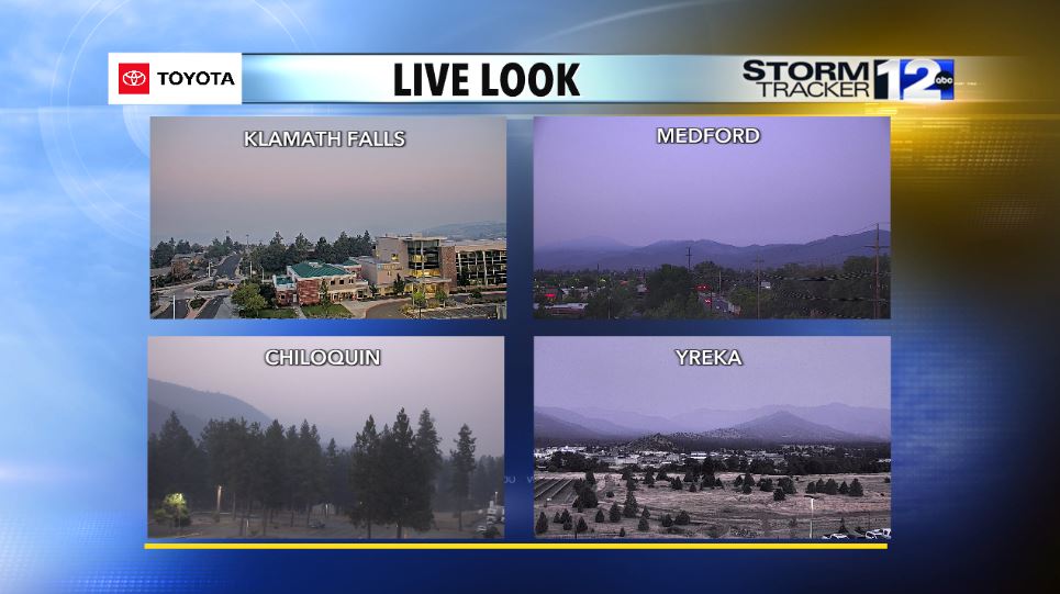
Smoke has settled in overnight and air quality is not looking great, especially in the Klamath Basin. Today, we can expect widespread smoke and haze due to multiple wildfires burning in and around our region, most of it coming from the Cram Fire in Central Oregon.

Several new Evacuation Orders (GO NOW!) and Evacuations Warnings have been issued for the Butler Fire in southwest Siskiyou County. Details HERE--->kdrv.com/news/top-stori…
Air quality isn't starting off in horrible condition for most areas across the region, but we'll have to keep a close eye on it today and likely tomorrow. Expect to see hazy skies and areas of smoke from multiple wildfires in and around our region.

