Ryan Snoddon
@ryansnoddon
CBC Meteorologist
Anyone else giving @bluesky a spin? Jumped in a few weeks ago and I'm enjoying it. Lots of folks from the weather/climate/science community have joined and are posting news and information, with far less... noise. If you're there, I'm here: bsky.app/profile/ryansn…
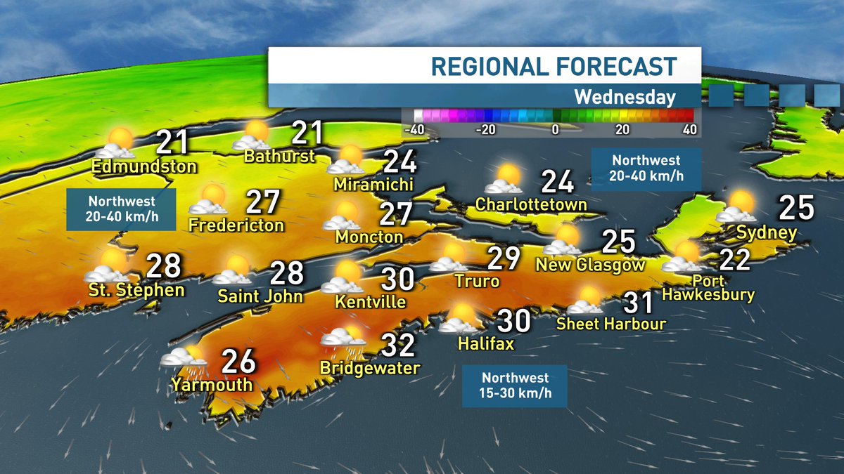
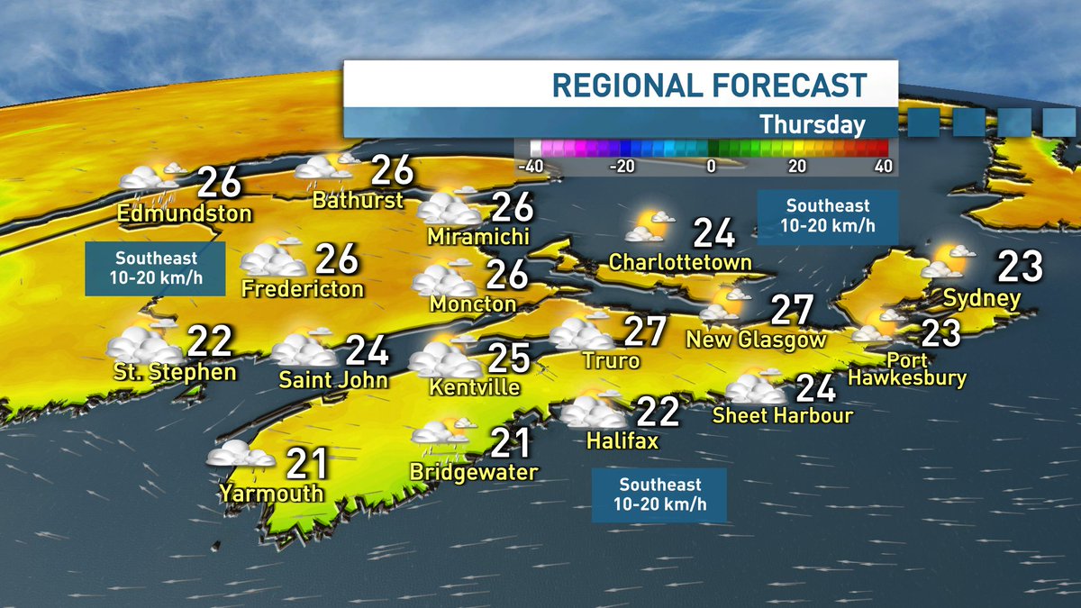
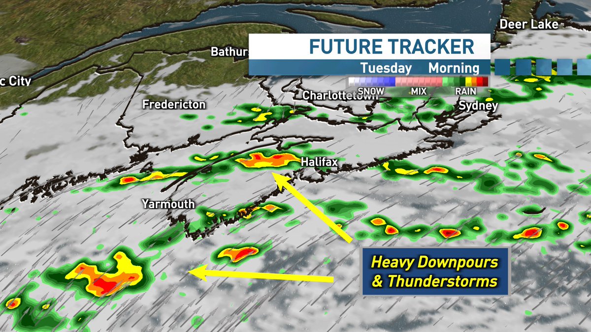
Downpours departing and humidity dropping overnight into Wednesday. Clouds clearing in the morning (early am shower risk for southern NS) then a beautiful afternoon for the Maritimes. Building clouds Thursday with showers Friday. System is looks set to clear for the weekend.
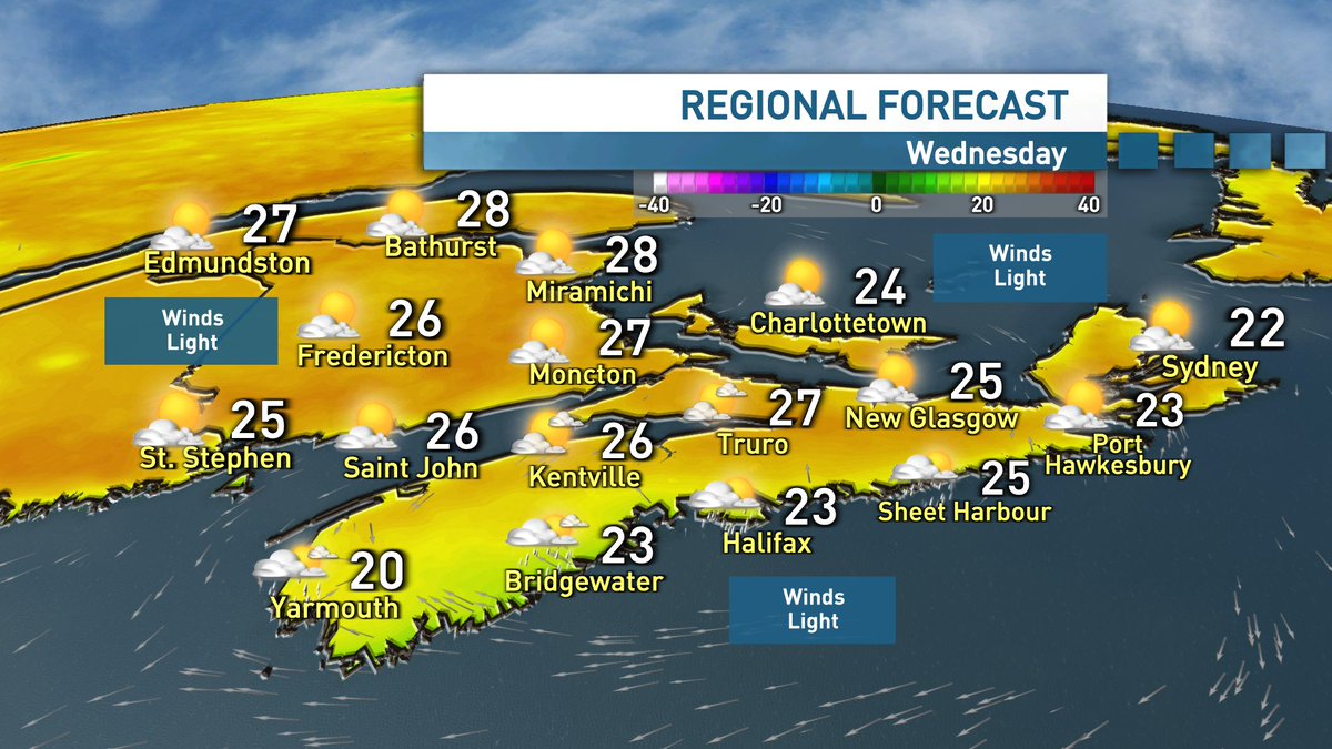
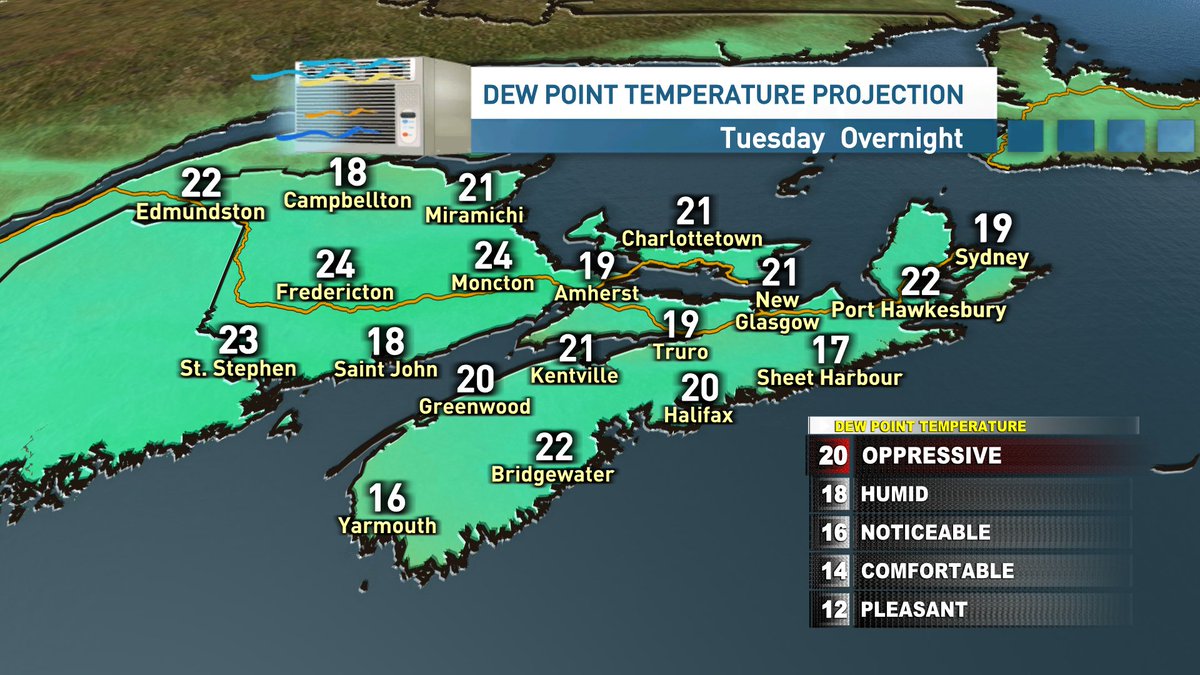
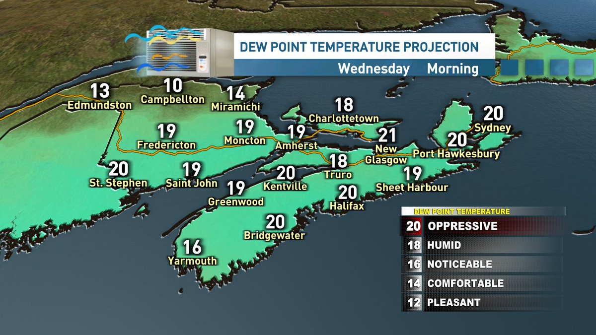
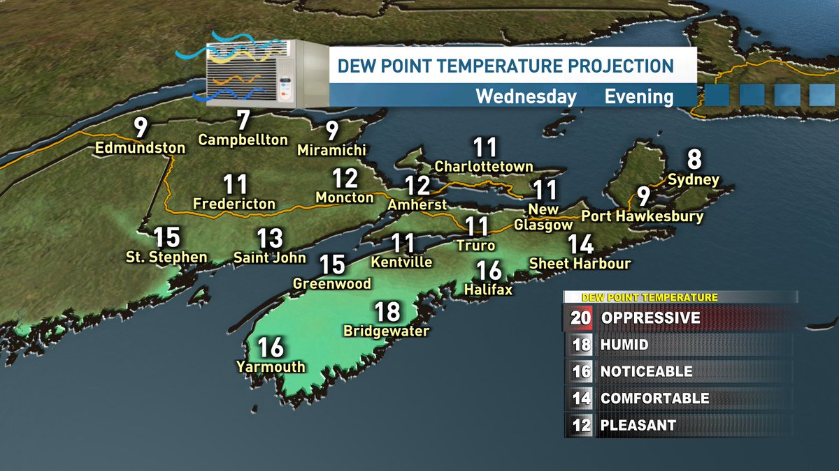
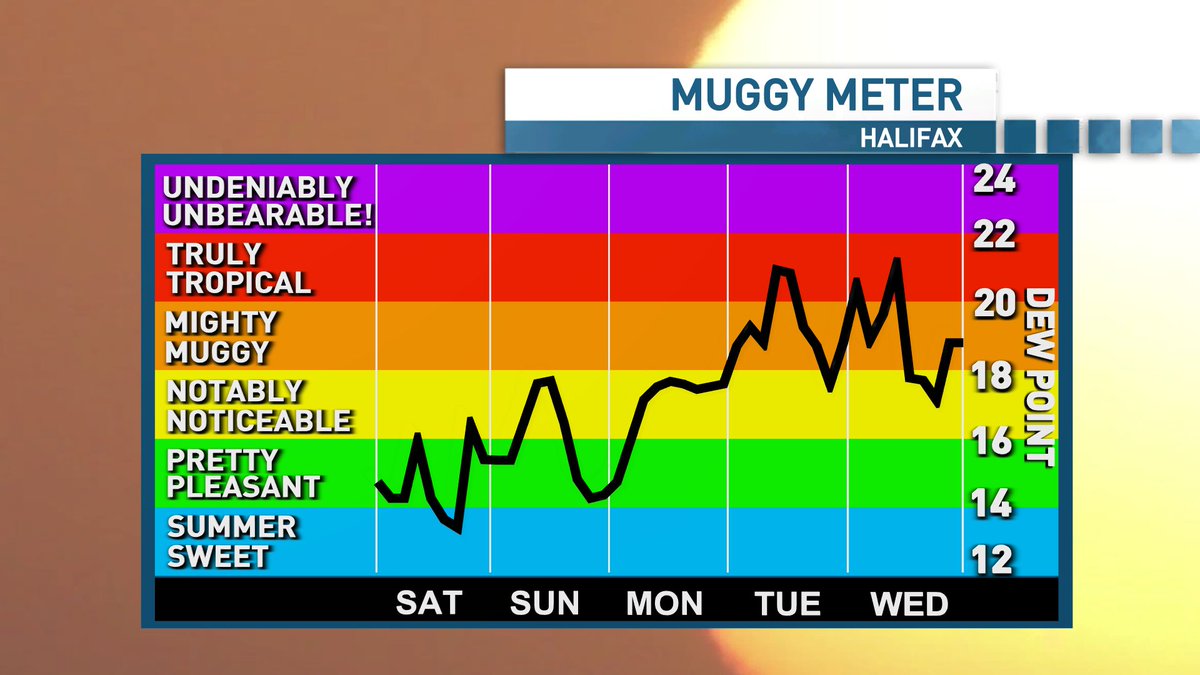
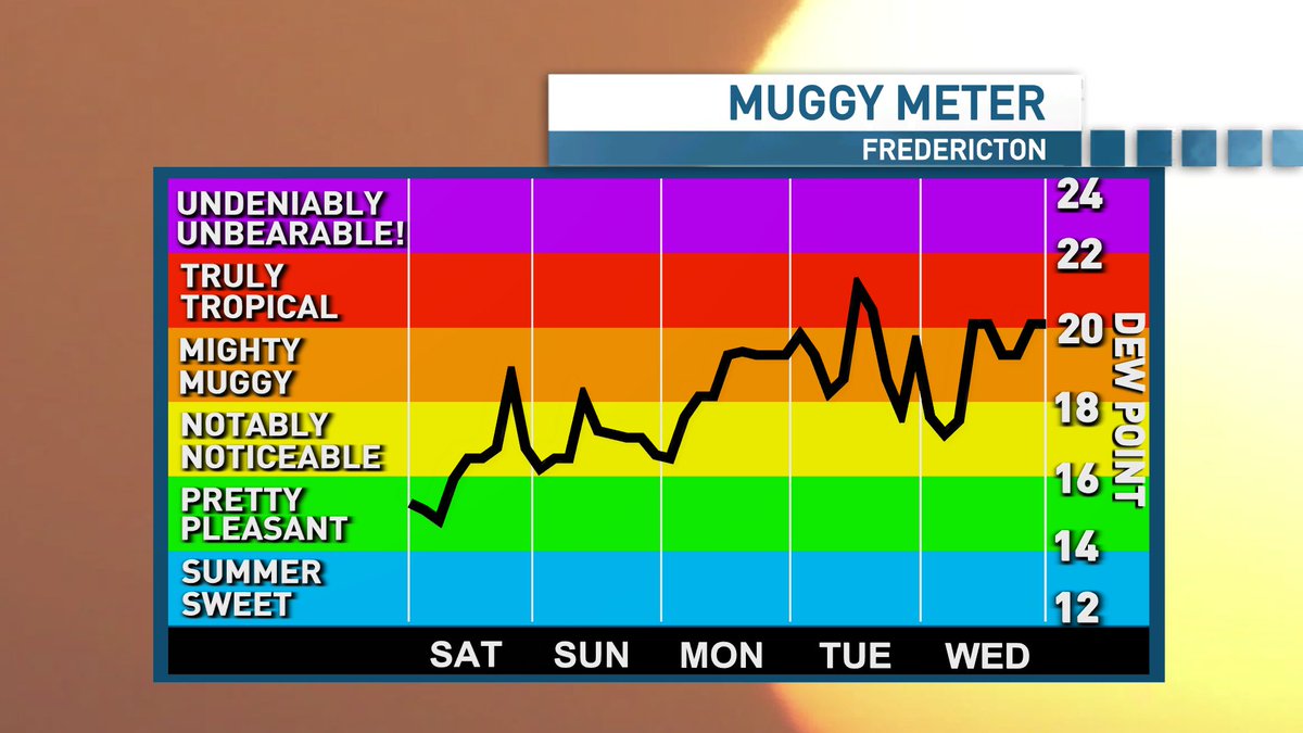
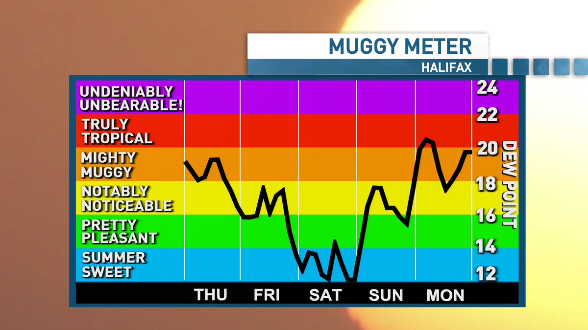
A muggy and uncomfortable night ahead in the Maritimes. Wednesday will be another warm/hot one for most, however dew points will be falling and the humidity dropping throughout the day as northerly winds usher in a drier air mass. Noticeable difference by Wednesday evening.
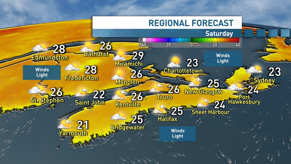
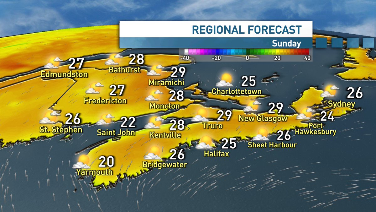
A beautiful mid-summer weekend on the way for the Maritimes. Temperatures will be toasty and the humidity will in the mix, but not oppressive. Looking ahead to next week, mother nature will turn up the temperature, the humidity and the shower + thunderstorm chances.
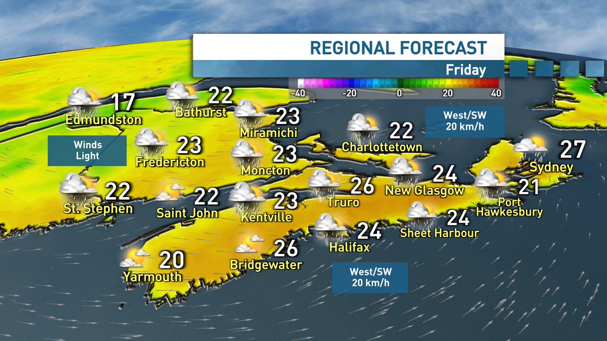
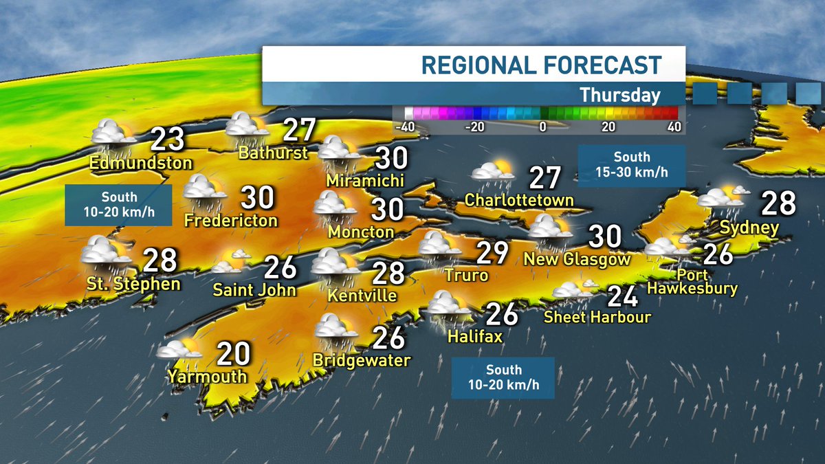
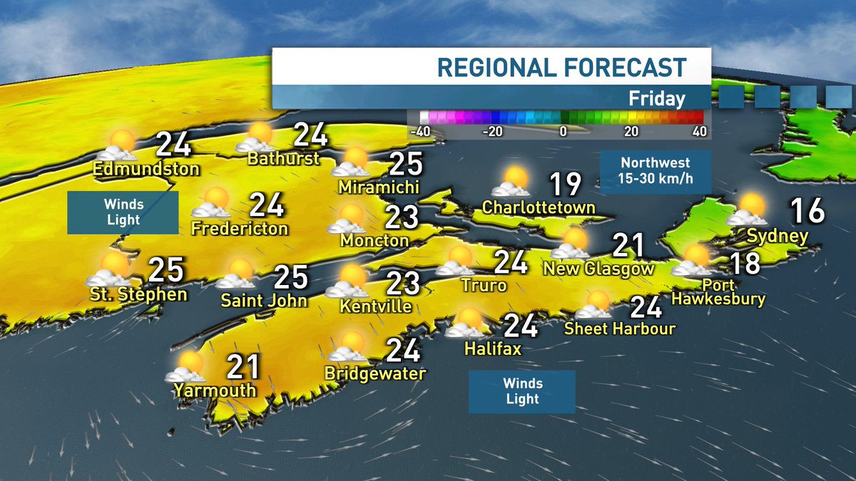
Increasing clouds and shower chances through Thursday afternoon & evening. Comfortable temperatures and humidity, however southeast winds will keep things cooler along the Atlantic coast. Showers on tap for Friday, however we're still looking at a solid summer weekend.
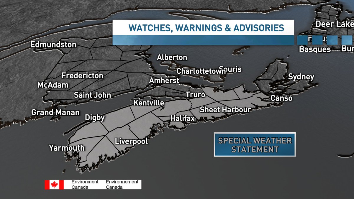
Special Weather Statement for most of mainland Nova Scotia. Remnants of Post-Tropical Storm Chantal will bring the risk of downpours and thunderstorms overnight and Tuesday. Greatest risk of intense rainfall rates & localized flooding will be across southern Nova Scotia.
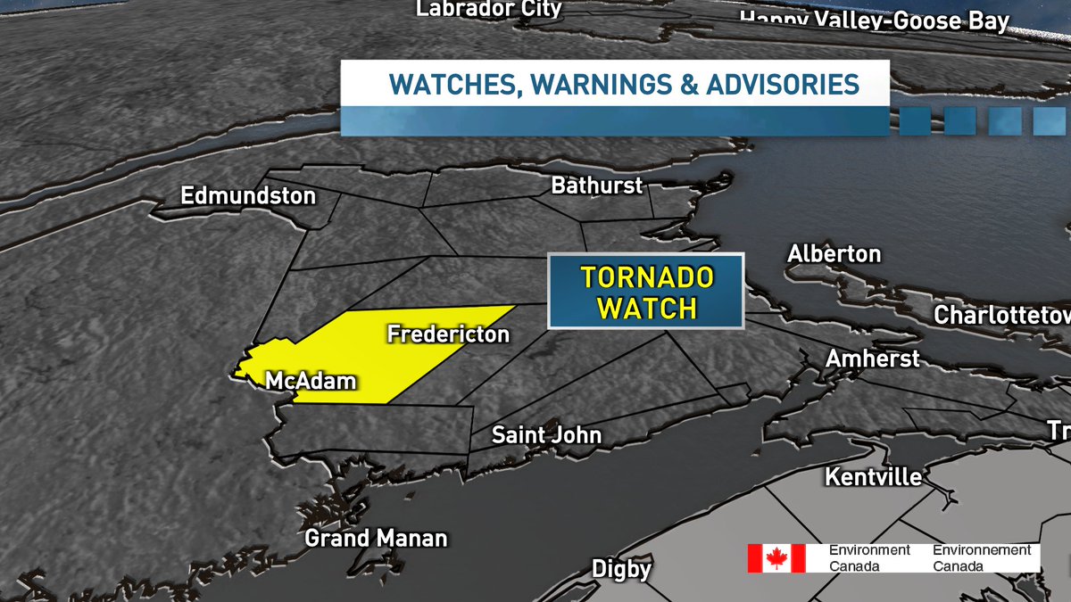
July 7th - 5:45pm TORNADO WATCH: Fredericton & Southern York County Favourable conditions for severe storms which may produce tornadoes. Strong damaging straight line winds, large hail, heavy rain also possible. Watch: conditions are favourable Warning: Imminent or occurring

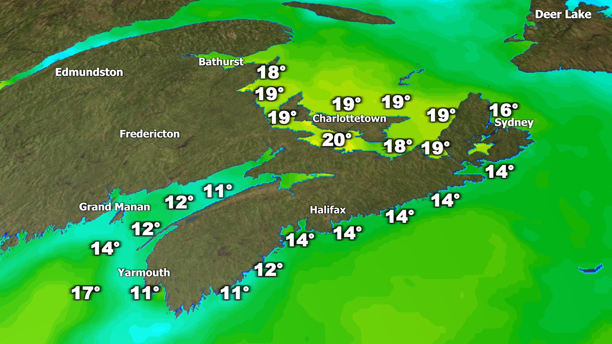
Satellite sensors are detecting the first sea surface temperatures near 20° of the season in the Northumberland Strait. Just 3 months ago, temperatures were near 0° in the Strait with some lingering chunks of ice.
Active this evening with showers and thunderstorms. Cooler temperatures and less humid for Friday, with a chance of isolated showers & storms. Nice Saturday for most, although lingering isolated showers for Cape Breton and eastern NS. Humidity builds back in through Sunday.
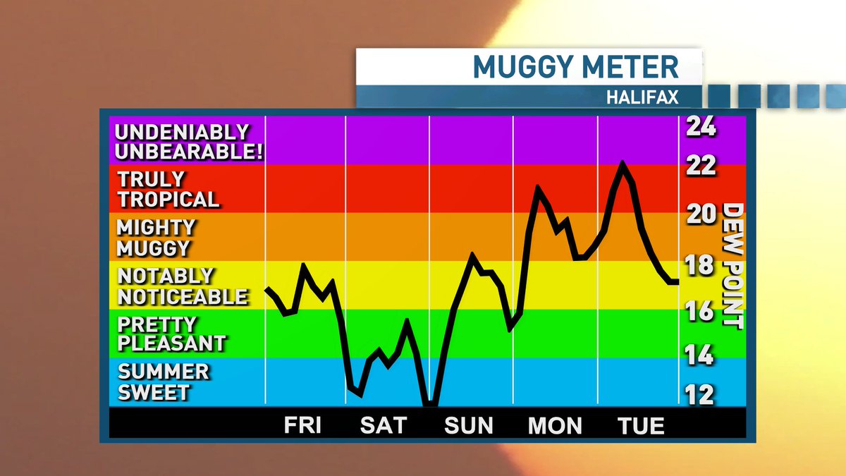
Muggy tonight & Thursday which means things will remain active. Best chance of thunderstorms on Thursday will be across New Brunswick and northern Nova Scotia. Mugginess fades through Thursday night & Friday... before rising even further through Sunday into Monday.
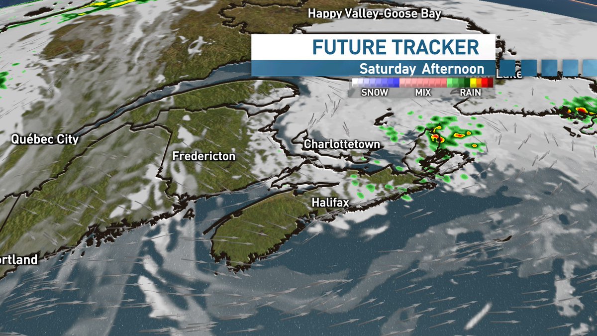
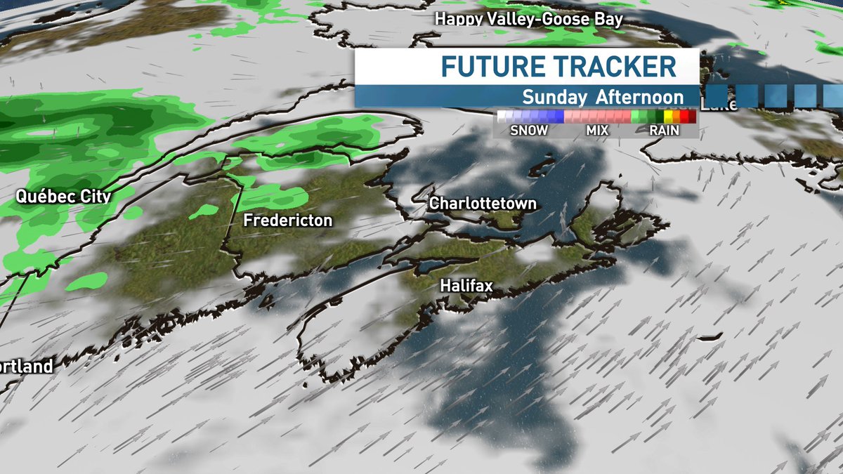
A nice Friday across the Maritimes. Showers roll in throughout the day Saturday with steadier rain & t-storms in the southwest on Saturday night. Lingering clouds and shower chances for Sunday. More details and timeline: NS: youtube.com/live/aOcs_AWfa… NB: cbc.ca/player/play/vi…
An extremely rare 30° day in Yarmouth, Nova Scotia today! This is just the 6th time the town has hit 30° since 1871 (154 years). Today's 30.4° is the first time to reach the mark in the month of June. Other 5 occurrences were in July (1911, 1968, 1977, 1993 & 2013) #nswx
Sizzling in the Maritimes today! Hot spot: St. Stephen, NB at 36.0° & Humidex: 45 New daily records in Fredericton, Moncton, St. Stephen & Kejimkujik. -Tied for 2nd warmest all-time at Keji -4th warmest all-time at St. Stephen -Tied for 8th warmest all-time at Grand Manan
Heat & humidity will soar Tuesday in the Maritimes! Temps will rise into the low to mid 30s with humidex values climbing into the high 30s and low 40s. Cold front brings afternoon and evening thunderstorms & some relief arriving thru Wednesday. Details: cbc.ca/news/canada/no…
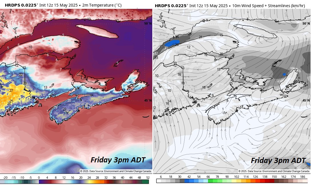
Frontal boundary will slide into the Maritimes on Friday. HRDPS projection for mid-afternoon shows temperatures in the south/west holding into the teens and low 20s. However east-northeast winds will usher in much cooler temperatures on the other side of the front! #nswx #nbwx
Summer warmth for a second day here in the Maritimes, with the hottest temps in Canada! 🇨🇦 Many new daily records including: Halifax, Sydney, Shelburne, Antigonish, Fredericton, Moncton, St. Stephen & Miramichi. First 30°+ temp of the season for NS at Malay Falls. #nswx #nbwx

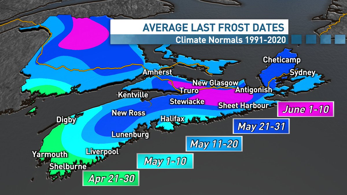
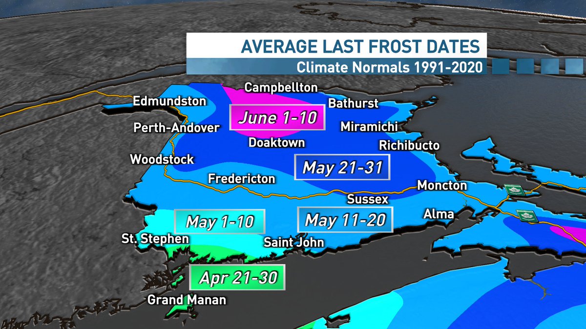
Does this nice weather have you thinking about getting your hands dirty in the garden? You might want to think twice before planting those frost sensitive plants just yet. My latest: cbc.ca/news/canada/no… #nswx #nbwx
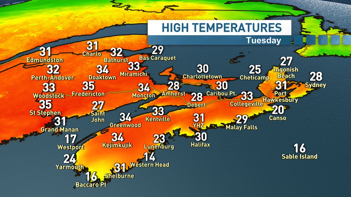
First 30's of the season in the Maritimes today! Miramichi, Bathurst & Edmundston all reached that mark & set new May 14th records. Widespread mid-high 20s elsewhere. More summer like warmth on tap for Thursday. Winds shift throughout Friday ushering in cooler air. #nswx #nbwx
Since July 2023, 21 of the last 22 months have seen global average temperatures 1.5ºC above the pre-industrial level, according to #ERA5 data - with July 2024 just 0.02°C below that mark. Read more about the latest findings in our #C3S Monthly Bulletin: climate.copernicus.eu/2nd-warmest-ap…
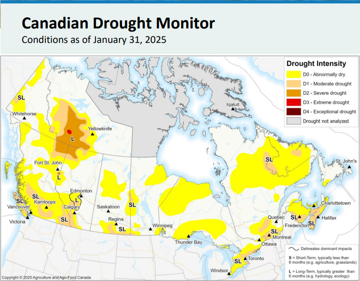
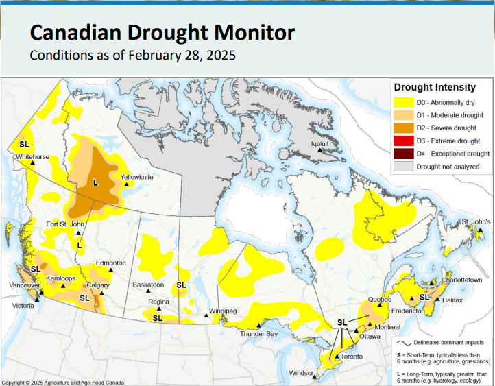
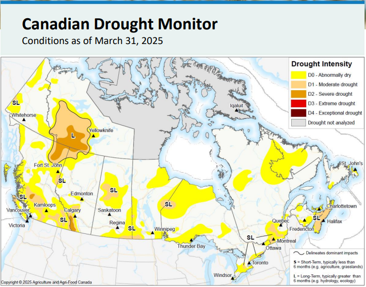
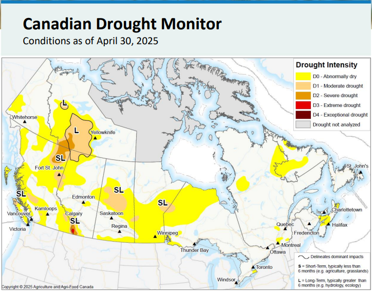
Welcomed news from the Canadian Drought Monitor. Thanks to near/above average precipitation this Spring, widespread moderate drought conditions have been reduced to a smaller area of abnormally dry conditions (as of April 30th) So far, May precipitation is on par. #nswx #nbwx
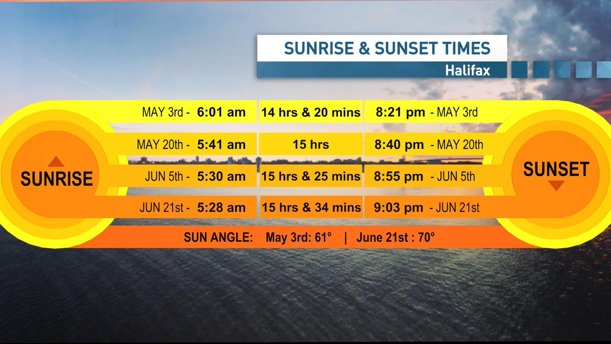
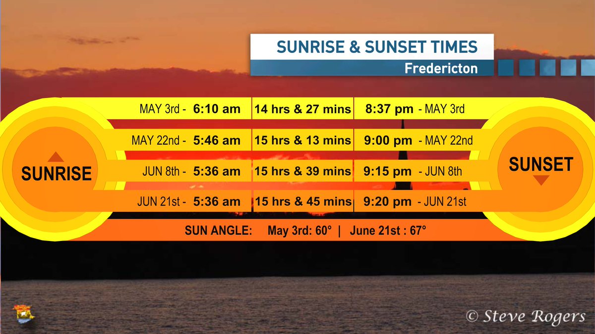
An update on where we are in terms of sunrise, sunset and daylight times. Still gaining more than 2 1/2 minutes per day, with sunrise times now near 6am. 15 hours of daylight by the time the May long weekend rolls around and the sun angle continues to rise! #nswx #nbwx