Paul Huttner weather
@paulhuttnerwx
Tweets about weather and life from MPR News Chief Meteorologist and Climate Cast Host Paul Huttner. Climate specialist. Sunset lover.
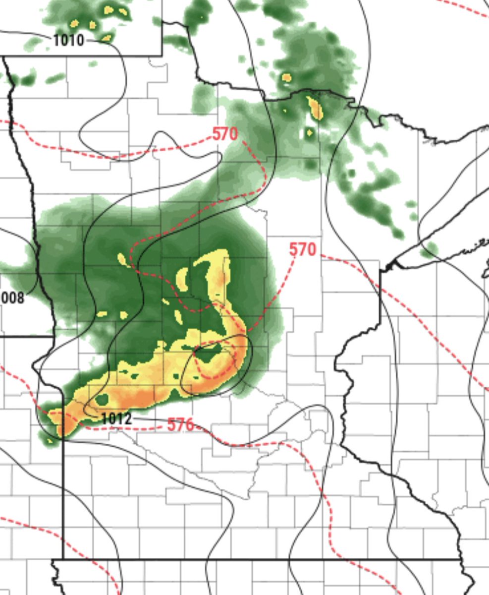
Busy radar today. Storms NW of MSP dumping heavy rain. Expect tropical downpours as they drift slowly into greater MSP area this afternoon. Local street flooding possible. #mnwx
Well that was a deluge. 2 to 4"+ rainfall across central and northern Minnesota. Now our latest air quality alert starts Thursday. But a cooler and much less humid air mass ahead next week with highs in the70s?? #mnwx mprnews.org/story/2025/07/…

NOAA SPC says a 60% chance for a severe weather watch soon including SE Minnesota. Highest devere and flooding threat has now moved SE of MSP area. #mnwx
2:56pm CDT #SPC_MD 1763 , #miwx #wiwx #mnwx, spc.noaa.gov/products/md/md…
Radar update: Locally torrential rainfall moving through greater MSP area. Local street flooding possible. Take it easy out there! Welcome to Miami. #mnwx
Flash flood warnings already in effect for NW Twin Cities. Flood risk expanding with locally torrential rainfall through this evening! 🌧️🌧️ #mnwx mprnews.org/story/2025/07/…

Lots of flash flooding in Ely and other areas of northern and central MN today. Preview of possible coming attractions around MSP and southern MN this afternoon and evening. Tropical downpours with dew points in the 70s! #mnwx
Ely is under a ‼️Flash Flood Warning. Ammie Peterson just shared this photo of Conan Street there. NWS reporting 6-12 inches of standing water on many Ely roadways. #mnwx
Heads up SW Twin Cities. Intense tropical deluge amongst the heaviest rainfall I've ever seen. Recorded 1" of rain in about 15 minutes here in SW Twin Cities. Serious flash flood potential if this line stalls over MSP tonight. #mnwx
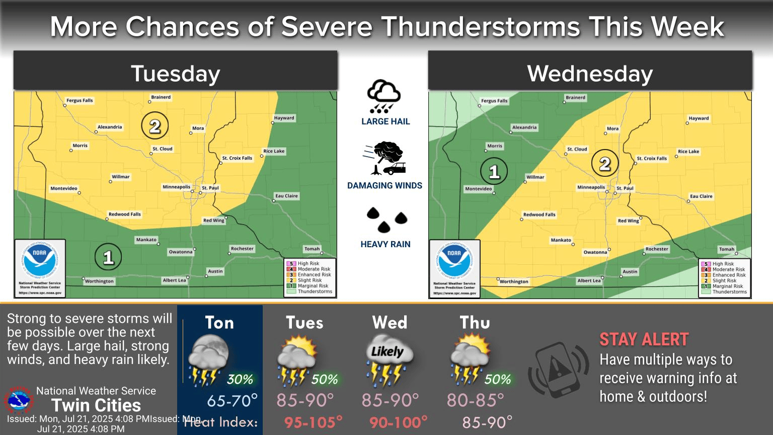
It's peak heat and storms through Wednesday. Grumpy storms shift further south into southern Minnesota Wednesday. Here's the latest on storm coverage and timing. #mnwx mprnews.org/story/2025/07/…

Enjoying our free sauna today? 🌡️ Highest storm and flood risk north of MSP. Better storm chances Wednesday late PM/evening. Here's an update on most likely storm timing and coverage. ⚡️ #mnwx mprnews.org/story/2025/07/…

I'm issuing a root beer float alert this week in Minnesota. That comes with a side of thunder. #mnwx mprnews.org/story/2025/07/…
A few models show severe MCS bow echo tracking from Red River Valley to central MN NW of MSP by midday Monday. May be fading to below severe levels before MSP area. But wind damage possible along I-94 corridor between Fargo and St. Cloud looks possible Monday AM. #mnwx
Severe thunderstorm watch and some warnings for SW Minnesota does not include Twin Cities. But we could get some rumbly storms with a lightning ⚡ show after about 9-10 PM tonight. Keep an eye on the western sky. #mnwx
Latest air quality alert issued for northern Minnesota this weekend. #mnwx mprnews.org/story/2025/07/…

Anyone up for some sunnier and drier days ahead?? We may actually see the sun tomorrow. 🌞 #mnwx mprnews.org/story/2025/07/…

How much rainfall did you get? 🌧️ Here's a look at rainfall totals from our latest super soaker. Areas west of the Twin Cities have recorded 10 to 15 inches of rain in the past month!! #mnwx mprnews.org/story/2025/07/…

Mostly garden variety thunderstorms moving through Twin Cities core now. Downpours, thunder, gusty winds to 45 mph and some hail possible. #mnwx
Tropical rainfall rate! #mnwx
In the last 25 minutes I have had 0.85 inches of rain. The rain has begun to ease off. MN-AA-58 #mnwx
Pretty good line of strong to marginally severe storms moving through greater MSP next 1-2 hours. Downpours, thunder, gusty winds and some hail possible. #mnwx
Severe thunderstorm warning for eastern Carver County until 6:30! 60 mph winds possible with this cell and hail. Victoria, Chan, Chaska in the path. #mnwx
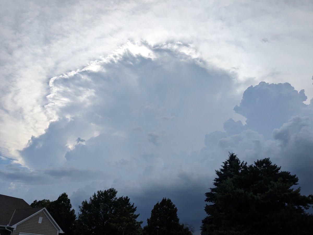
Pretty tropical towering cumulus and CB billowing just SW of MSP now. A Miami sky. #mnwx