MemphisWeather.net
@memphisweather1
The best in Memphis weather for 25 years! Curated by meteorologists EP (@NWAS Digital Seal), RH & #TeamMWN. Official weather for the biggest events in Memphis!
As evidenced lately, spring severe storm season is here! If you still use the MWN app for your severe weather alerts, you need to migrate to our StormWatch+ app. Alerts to MWN will shut down soon. More info: cirrusweather.zendesk.com/hc/en-us/artic…
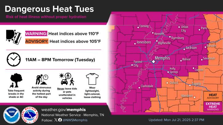
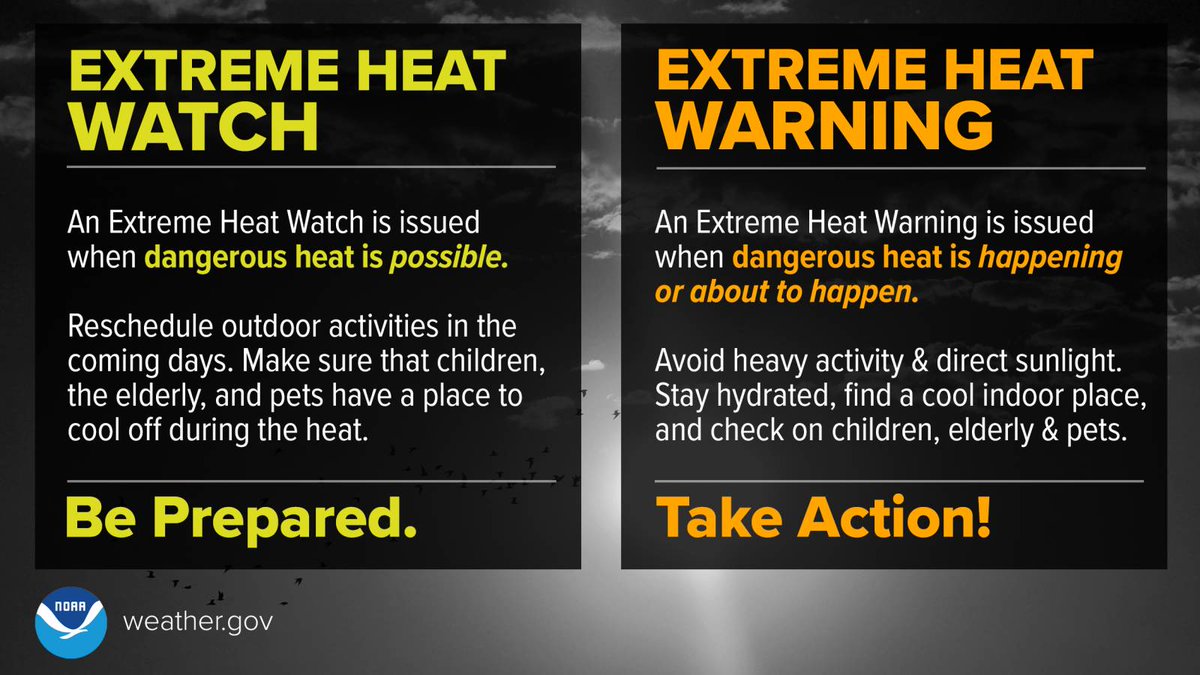
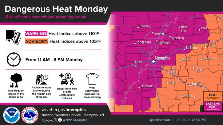
Tonight will bring clear skies and lows dropping into the upper 70s. Once again, an extreme heat warning is in effect for tomorrow until 8pm. Highs will be in the mid to upper 90s, with heat indices nearing 110°. Stay hydrated and remain cool if outdoors for extended periods./AO
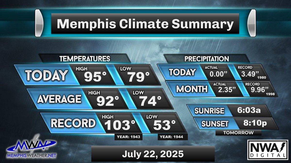
Today's Memphis weather almanac - Avg high/low: 92/74. Record high: 104 (1934+). Record low: 52 (1947). Sunrise: 6:03am Sunset: 8:11pm #memwx
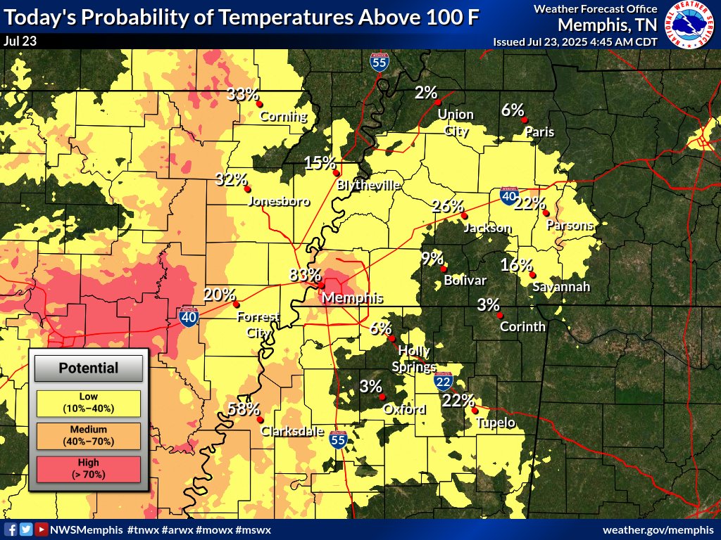
At sunrise, most areas are just barely below 80°, signaling another excessively hot day. Today may have the best chance of reaching 100° this week and it'll continue to feel like 108-112° in the afternoon. Stay hydrated and take frequent breaks if outdoors! Little relief expected…
Tomorrow morning, temps will fall to the upper 70s then rise to the upper 90s by afternoon. Heat indices will be near 110°. An extreme heat warning remains in effect tomorrow, so stay cool and try to stay indoors. Unfortunately, rain won't be near to provide relief from the heat.…
It was another very hot and humid day in the metro. Temps reached the mid 90s with heat indices near 110. The metro remained dry with the closest showers being well-off to the east. Very hot and humid conditions will continue this week. /ER
It's another very hot day in the metro. Temps are currently in the mid 90s, with heat indices over 100 and mostly sunny skies. Expect heat indices near 110 later this afternoon, as we remain under an Extreme Heat Warning. Please be cautious when outdoors. Tonight's Low: 79. /MM
Today's Memphis weather almanac - Avg high/low: 92/74. Record high: 103 (1943). Record low: 53 (1944). Sunrise: 6:02am Sunset: 8:11pm #memwx
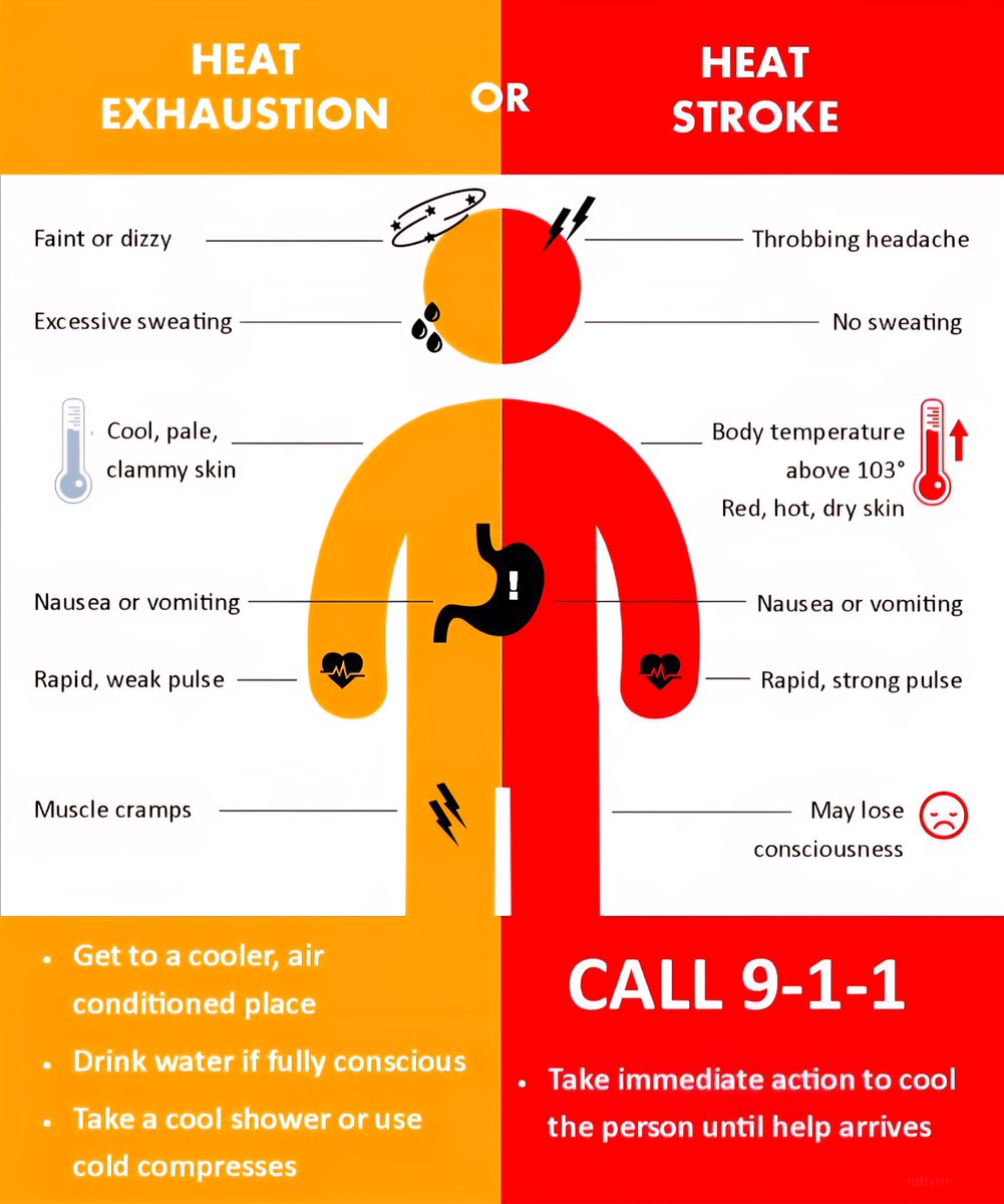
It's getting real (hot) now y'all! The hottest days of the week are today and tomorrow as temps flirt with 💯 and Extreme Heat Warnings continue. Heat indices will reach 110°. The effects of heat are cumulative, so make sure you are aware of the signs of heat illness.
"Hurricane Elvis" roared through Memphis 22 years ago on July 22 with up to 100 mph wind downtown, knocking out power to 70% of MLGW customers. WMC's coverage linked below brings back memories. Were you here, and what do you remember? youtu.be/U0CGj_J2JiA?si…
It has been very hot and humid today across the metro, with dry conditions offering no relief. Highs reached the mid 90s, with heat indices around 110°. The oppressive heat will stay over the next several days. /AO

It's a very hot day in the metro. Temperatures are currently in the mid 90s, with heat indices over 100 that could reach 110 later this afternoon. An excessive heat warning is in place. Please exercise caution when outdoors. Expect temperatures in the upper 70s tonight. /MM
📢PSA: @CityOfMemphis OEM continues maintenance of the Outdoor Warning Siren System today (7/21/2025). You may hear sirens intermittently across parts of the City. 📷 **NO WATCHES / WARNINGS currently in effect!**
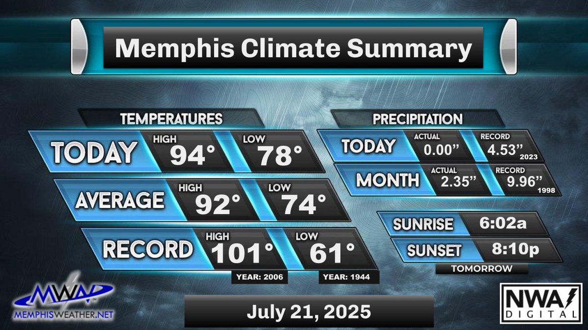
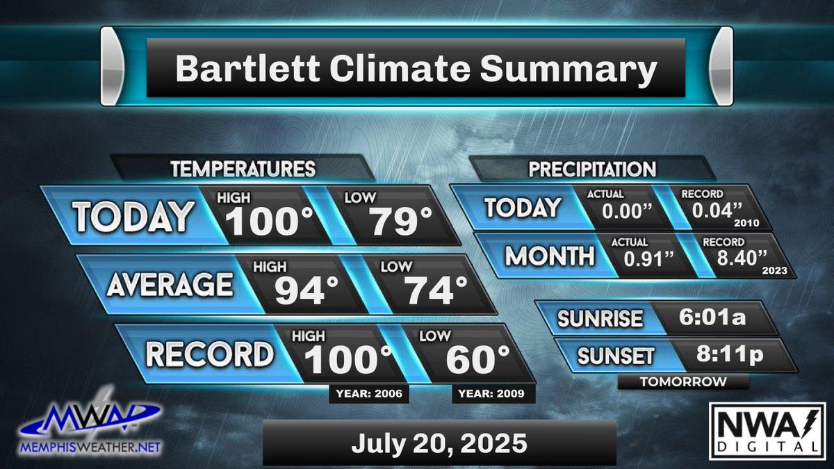
Today's Memphis weather almanac - Avg high/low: 92/74. Record high: 101 (2006). Record low: 61 (1944). Sunrise: 6:01am Sunset: 8:12pm #memwx
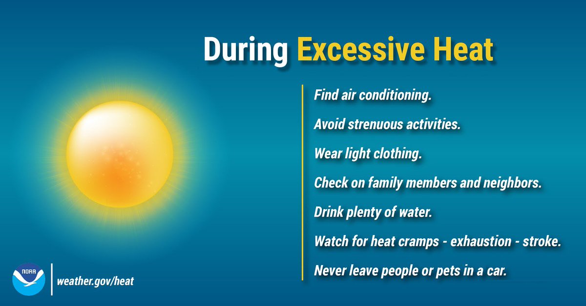
We're starting a hot 🔥 week off with temps in the upper 70s and expect mid to upper 90s with heat indices near 110° this afternoon. An isolated shower can't be ruled out, but is highly unlikely. Check out these tips to ensure you stay safe and healthy in this extreme heat!
There's hot and then there's #StupidHot! Seriously, very little heat relief is expected from isolated showers or cooler nights, and heat indices will reach near 110° daily. Make sure you are staying cool, hydrated, rested and watching out for others who might need a hand!
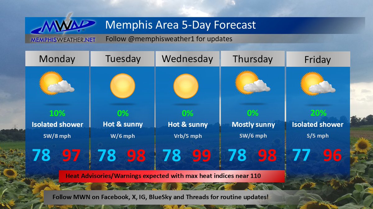
Going into the morning, temps will fall to the upper 70s then rise to the upper 90s by afternoon. An extreme heat warning is in effect for tomorrow, so stay cool and try to stay indoors. Heat indices will approach 110°. An isolated PM shower or t'storm is possible tomorrow. /ER
Besides a few isolated showers to cool things down, it was hot and humid. Temps generally stayed in the low to mid 90s, but Bartlett tied their record high temp of 100 today! Heat indices reached the low 100s. Unfortunately, temps will get hotter as the week progresses. /ER

3:15pm-Isolated showers and t'storms continue to pop up across the metro, with most north of the MS/TN border. These may have heavy rain and some lightning. Watch for additional pop up showers and t'storms later into the afternoon. /AO
2pm- It’s a hot and humid day, with showers and t’storms affecting parts of the metro. Temperatures are in the low 90s where rain hasn’t fallen. Isolated showers and t’storms are expected through the afternoon and evening, with highs reaching the mid 90s. /AO
12:50pm- Some isolated showers have popped up across the metro, mainly east of the river. These will be short lived and provide little relief from the heat over the next hour or two. Reminder that "if thunder roars, go indoors". /AO