WHO 13 Weather
@WHOWeather
Weather coverage for Central Iowa
This is the view of downtown Des Moines at 8:11 PM showing the storms, which were severe, dropping heavy rainfall as they move north.

Radar update... keeping an eye on storms to the north: #iawx
A few storms have popped up in the heat over southeast Iowa this afternoon: #iawx
Timelapse of the fog burning off this morning in Ames from our Gateway Hotel camera
A foggy view from our Gateway Hotel Skycam in Ames. Fog should burn off around the area by roughly 9am. #iawx

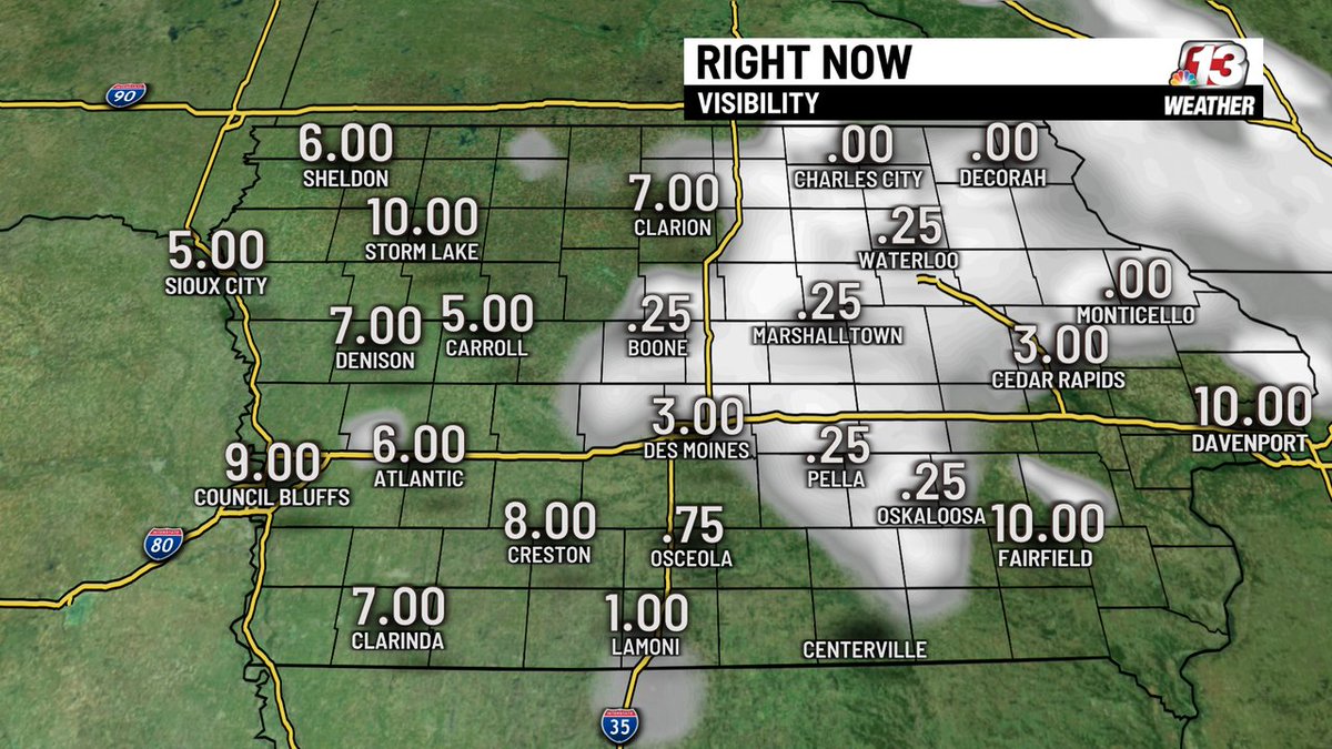
Good morning! Watched for reduced visibilities due to fog in some areas through about 9am. It's gonna be a HOT one. #iawx
A Flood Watch continues for the counties shaded in green through tomorrow morning. Heavy rain earlier today and more heavy rain expected overnight, could cause excessive runoff which could cause flooding of rivers, creeks, streams and low-lying and flood-prone areas.

WAKE UP WEATHER: It is a mostly cloudy morning in Central Iowa. #iawx
Wake Up Weather: Skies are cloudy as rain continues to push east. There are some lingering showers across Iowa. #iawx

A Severe Thunderstorm Warning continues for Polk, Story, Boone an Dallas Counties. This storm is moving east at 40 MPH. 60 MPH wind is possible.

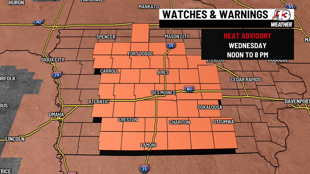
A Heat Advisory will be in effect from noon to 8 PM today across Iowa due to temperatures in the 90s and heat indices just over 100. #iawx

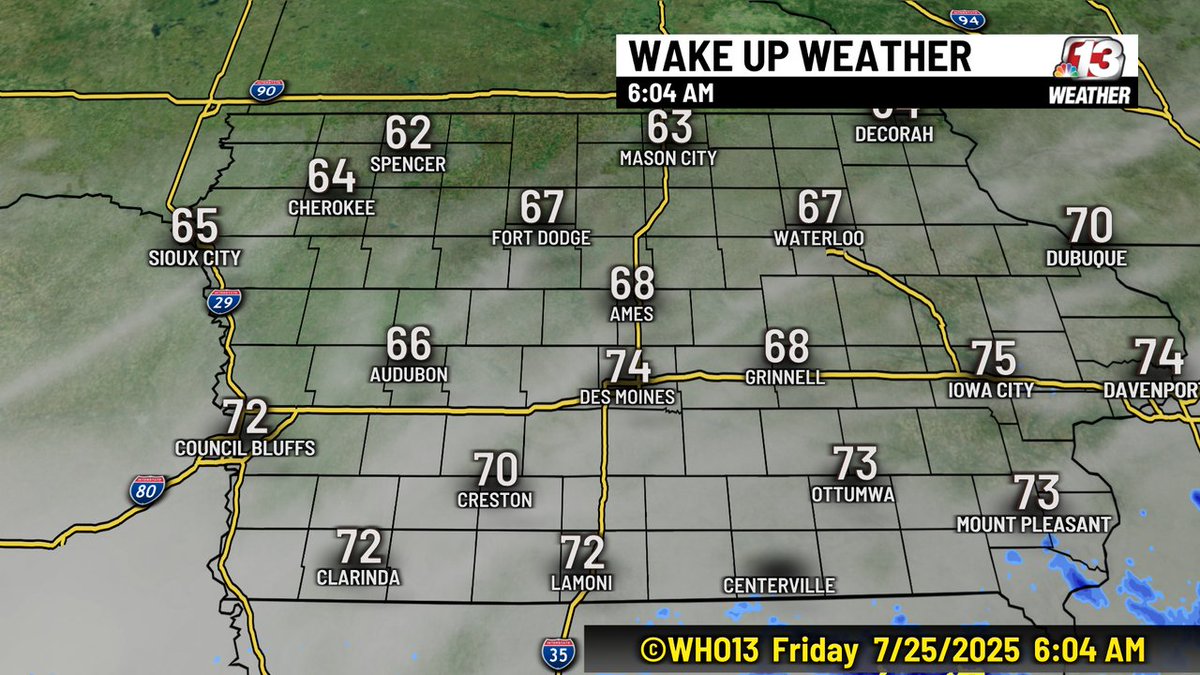
Wake Up Weather: Partly cloudy this morning with very warm and humid conditions. #iawx

Here is the ETA for the Severe Thunderstorm over Warren, Clarke and Madison Counties. 60 MPH wind is possible with this storm.

A Severe Thunderstorm Waring has been issued for Dallas and Madison Counties until 8 PM. This storm is moving NE at 15 MPH. 60 MPH wind and quarter-size hail are possible.

There is a Heat Advisory in effect for all of central Iowa from Noon to 8 PM. The heat index will be around 105. #HeatAdvisory
It was another crazy weather event as an intense thunderstorm sat over the southside of the Metro Sunday evening. It produced 1-3" of rain which caused some flash flooding. Conditions will improve overnight with drier conditions.

Many areas were soaked again today- some with more than 5"! So far this month, Des Moines has picked up 6.51" of rain at the airport! Here are some others that record rainfall. Keep in mind some isolated locations have likely had more than 9" this month!

More storms are expected tonight. Some could be strong/severe and produce locally heavy rain. For this reason, a FLOOD WATCH has been issued for much of central Iowa tonight into Sunday morning. Be weather aware and stay safe!