Arko Lucieer
@TerraLuma
Head of School of Geography, Planning, and Spatial Sciences and Professor in Remote Sensing at the University of Tasmania. Founder of TerraLuma research group.
I am currently advertising a new 3-year research position in my TerraLuma team: Research Associate in Drone Field Operations (Academic Level A) The position will support the Terrestrial Ecosystem Research Network’s (@TERN_Aus) Dronescape project. careers.utas.edu.au/cw/en/job/5012…
"🚨 JOB OPPORTUNITY 🚨 We're hiring a postdoc with R/Python programming skills to join our project on fuel load mapping using TLS, GEDI, & L8 data. Apply by submitting a cover letter & CV by Dec 1, 2024, to [email protected]. Don’t miss out! carlos-alberto-silva.github.io/silvalab/oppor…
We're looking for a postdoc position in the IRSS!📢 🛰️ Canada-wide mapping of forest fuel attributes 📍@ubcforestry, Vancouver 🗓️ Jan 1 2025 🔗postdocs.ubc.ca/ad/58274 Application details in the link above ☝️ @PFC_CFS #remotesensing #postdocjob
Very proud of our colleague Prof Matt King @DeformedEarth for having been awarded a prestigious ARC Laureate Fellowship!
Huge congratulations to @AntarcticSciAus Director Prof. Matt King @DeformedEarth and Chief Investigator Prof. Anya Reading @dataforwisdom on being awarded a 2025 Australian Laureate Fellowship! @UTAS_ | @arc_gov_au Project details below ⬇️
Huge congratulations to @AntarcticSciAus Director Prof. Matt King @DeformedEarth and Chief Investigator Prof. Anya Reading @dataforwisdom on being awarded a 2025 Australian Laureate Fellowship! @UTAS_ | @arc_gov_au Project details below ⬇️
📣 Exciting News! I'm thrilled to announce the release of my new book: Introduction to GIS Programming: A Practical Python Guide to Open Source Geospatial Tools! Unlock the power of geospatial data with Python! This hands-on guide is crafted for both beginners and intermediate…
Few months ago but... New paper out! ⚠️🗞️ Here we used an optical flow algorithm to co-register drone-based hyperspectral imagery and RGB imagery to high accuracy 🚁📈 Big thanks to co-authors @TerraLuma @EC_lambda & Darren Turner mdpi.com/2504-446X/9/2/…
In #Antarctica, a daily radio check or “sked” is more than a safety protocol. It’s a lifeline, a laugh, a voice from the world beyond the ice❄️📻❤️ Short featured research supported by @AntarcticSciAus @AntarcticaNZ @IMASUTAS @niwa_nz @AntaPlatform youtube.com/watch?v=C9Jda8…
With deadtrees.earth we aim to uncover global tree mortality dynamics with satellite data. We use drone data as a reference. The coverage is growing rapidly but is still sparse in Africa and Asia. Join the initiative if you have drone RGB orthoimages of any forest :-)
Many heartfelt thanks to the organisers for this event. Thanks also to ABC Radio National for the image of Jamie. Please share amongst your networks.
A true giant of Tasmanian conservation, science, education and advocacy, Jamie’s commitment and contribution to our island, its people and its wild places cannot be overstated. Celebrate his life and legacy this Friday, 4pm @ Cascade Gardens. Photo: ABC Radio National.
WE ARE RECRUITING ! Lecturer or Senior Lecturer in Marine Spatial Science- @IMASUTAS @seafloorness careers.utas.edu.au/en/job/500373/… Contact me for more information. Position closes 30th November 2024.
Distinguished Prof. Jamie Kirkpatrick passed away yesterday. A beloved colleague at the heart of our School for 50+ years @UTAS_ , his kindness, dedication, and commitment to the Tasmanian environment will not be forgotten. He will be missed.

Gutted by the passing of dear friend, philosopher and guide Jamie Kirkpatrick. He personified geography and was a rare Renaissance Man in the age of specialisation. Grateful to him for introducing me to saltmarshes & much else. Photo @flettsflotsam from recent field trip. ❤️
Checkout our preprint: deadtrees.earth - An Open-Access and Interactive Database for Centimeter-Scale Aerial Imagery to Uncover Global Tree Mortality Dynamics biorxiv.org/content/10.110…
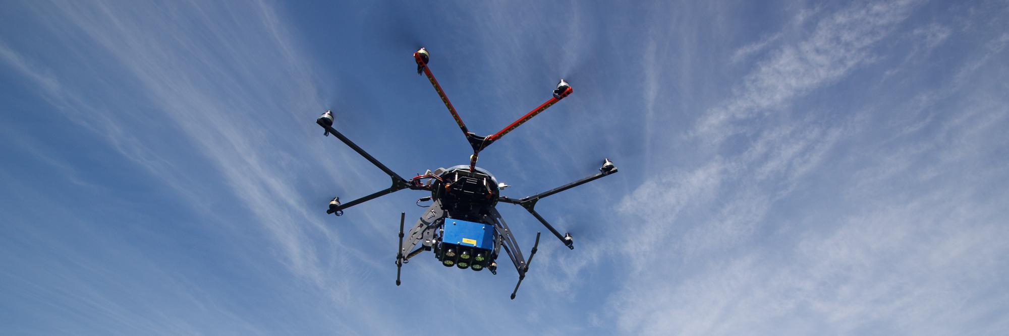
Excited and proud to lead this drone program for @TERN_Aus with Associate Professor Ben Sparrow from Uni Adelaide! Key contributions in the field and processing pipelines by @JCMontesHerrera
🎮 The TERN #drone remote sensing program is a standardised, nationwide #ecological data collection program. It is a collaboration between the TERN teams at @UniofAdelaide and @UTAS_. Read more: bit.ly/3XG6Nle #NCRISimpact
My name in Landsat
Check out the interactive 'Your Name in Landsat' app by @NASA_Landsat! See letters in Landsat images from 400 miles in space! 🛰️📡🌎 landsat.gsfc.nasa.gov/apps/YourNameI…