
Synoptic Weather
@SynopticWX
Synoptic Weather Beta Version Available NOW: http://synopticwx.com The weather model platform that will forever change how you use and consume weather data...
Keeping an eye on the potential for tropical development this weekend near Florida/Southeast US Coast. No indications of anything intense, but a weak tropical cyclone isn't off the table and heavy rain regardless likely from Florida to perhaps parts of the SE Coast.


Big drop in humidity coming!! Much more pleasant weather being modeled by data across the Eastern US to start out August. Watch dew points fall from mid-upper 70s early next week to the 50s by the end of next week.
The GFS is indicating a rare 600 dm ridge for early next week centered over the Mississippi River! Notable heat continues as we work into early next week. Global data along with mesoscale models available at any zoom, for any parameter here: synopticwx.com

Monitoring for the risk of heavy rainfall and perhaps flooding concerns this weekend across the Northern Ohio Valley & Lower Great Lakes region. Critical rains for some of these areas that have turned drier! A subtle stationary boundary is expected to set up combined with very…
All the makings of another heavy rainfall threat this weekend in the Ohio Valley. Upper-level disturbance shown here on the GFS on synopticwx.com combined with extremely high PWAT values will likely lead to another localized flooding threat at the minimum.

We have added the ECMWF AIFS to Synoptic! Utilize most hi-resolution and interactive platform for the AIFS for: 🔴 Sim Radar 🔴 QPF 🔴 Wind Speed 🔴 Upper Air Heights, Winds & Temps 🔴 Snow Totals Check it out at synopticwx.com


Nasty line of storms expected this evening across E. Iowa into parts of Wisconsin and Illinois. Damaging wind gusts will be the biggest threat. 4 Panel here indicates decent supercell composite values along with high instability. Don't be shocked to a tornado or two as well.

Map access and and parameter multi-panels available HERE: synopticwx.com
Severe storm cluster potential ramps up this evening for the Central Plains. A very unstable environment and moderate wind shear will increase the odds of a southeastward diving cluster with damaging wind gusts of 70 + MPH.
Severe storm cluster potential ramps up this evening for the Central Plains. A very unstable environment and moderate wind shear will increase the odds of a southeastward diving cluster with damaging wind gusts of 70 + MPH.

A few spotty showers today across the Ohio Valley but overall great weather for 4th of July activities! More widespread storms down in Florida with the tropical disturbance and the Plains.


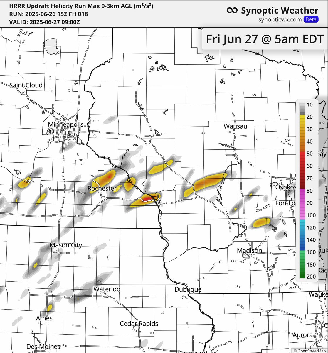
Monitoring for the potential for a few tornadoes across parts of Minnesota, Iowa and Wisconsin this evening. Storm tracks from the latest hi-res data indicate rotating storms especially in SE Minnesota and NE Iowa. Model data available on synopticwx.com!


Solid support among ensembles and operational data (ECMWF & GFS from @SynopticWX attached here) for an active storm cluster pattern in early July across the Midwest and Great Lakes region. Pattern will likely be busy at the turn of the month and beyond...…
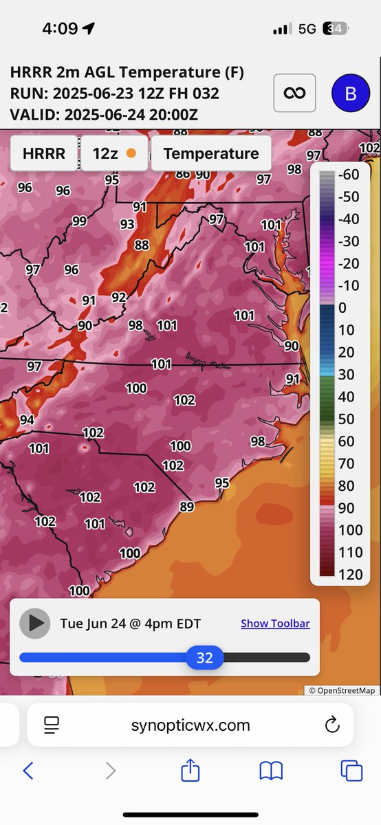
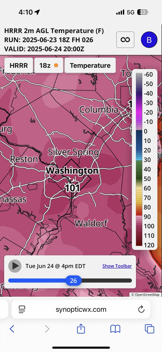
Widespread temperatures near or into the triple digits tomorrow in the mid-Atlantic to southeast. Latest hi-res guidance indicates over 100F even in the nation’s capital tomorrow afternoon. 🥵
Widespread heavy rainfall is expected this week throughout the east/central Plains and Upper Midwest. Several locations receiving multiple inches of rainfall. #agwx
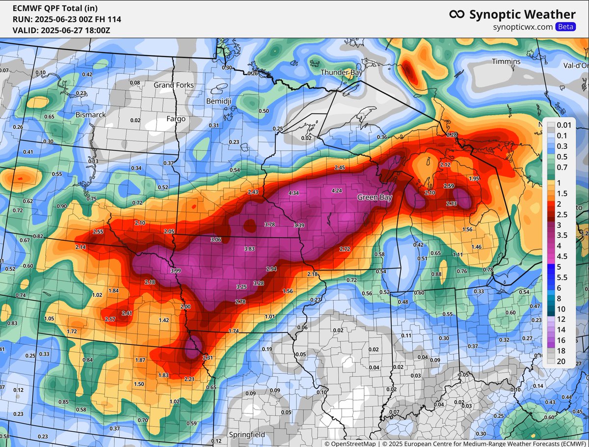
Excessive rains coming to the Midwest next week as a steep gradient will combine with Gulf Moisture transport and remnant moisture from Hurricane Erick. Several inches of rain likely following extreme heat this weekend!


500mb anomaly and height lines on the ECMWF from synopticwx.com highlights the heat dome that will set up into early next week. This set up will lead to widespread record breaking heat across the northeast US!

Utilizing the 4 panel tool on synopticwx.com this AM to analyze the severe weather potential. PLENTY of instability and wind energy to support severe storms this afternoon/evening. Likely a few tornadoes too given helicity track signals.

⚠️A round of severe weather appears likely tomorrow. I wanted to nail down where I think there could be the greatest potential for all modes of severe weather including… -Tornadoes -Damaging winds -Hail -Flash flooding Right now timing is 5-10pm or so west to east. Local…
We're still monitoring the risk for a severe storm cluster this weekend across the Upper Midwest and Ohio Valley. Extremely high CAPE and high pressure ridge building will allow for storm clusters to ride along the ridge.

June top #Derecho pattern days since 2010. Some big memorable ones in this analog set. The plot on the left is the pattern responsible for producing them. The plot on the right is the ECMWF forecast. Something to watch closely in coming days!