
Rich Wirdzek
@RichWirdzekWx
Chief Meteorologist @47abc WMDT | Emmy and AP Award Winner | Occasional help for @WHIZnewscom | AMS TV Seal of Approval | Prior 📺: @whiotv & @wcbinews
DRAMATIC video of a resident narrowly escaping the Smith Island tornado, while a house next door takes a direct hit. (language warning). Video from Kathy Taylor-Donaway. Last loop is in slow motion #mdwx #smithislandmd
It’s a Fair Time at the Delaware State Fair! We’ll be broadcasting live starting at 5:30 on WMDT!


Tue 7:10pm: Avoid travel in parts of northern Sussex county - flash flooding is possible. Little to no movement with these storms.

NEW: (Until 11:45p Thu) Flash Flood Warning for Bethany, South Bethany and Ocean View. Stay off the roads if you live near Hwy 26 and Rt. 1!

Heads up in the Dover area! FLASH FLOOD WARNING for the city and south, including Camden.


NEW: The Severe T'storm Watch to our west has been extended to cover the lower shore until 12am. Damaging downburst winds are possible, along with flash flooding.

⛈️ Severe storms possible again this evening l Big storms will fire in the DC-Baltimore areas after 4pm. These will cross the Bay and impact Delmarva after 7pm. Damaging winds + flooding are possible, with even a tornado possible west of the area along the I 95 corridor.


DESTRUCTIVE WINDS: Heads up Kent (MD) and Queen Anne's! 70-80 mph winds possible with this intense line of storms.

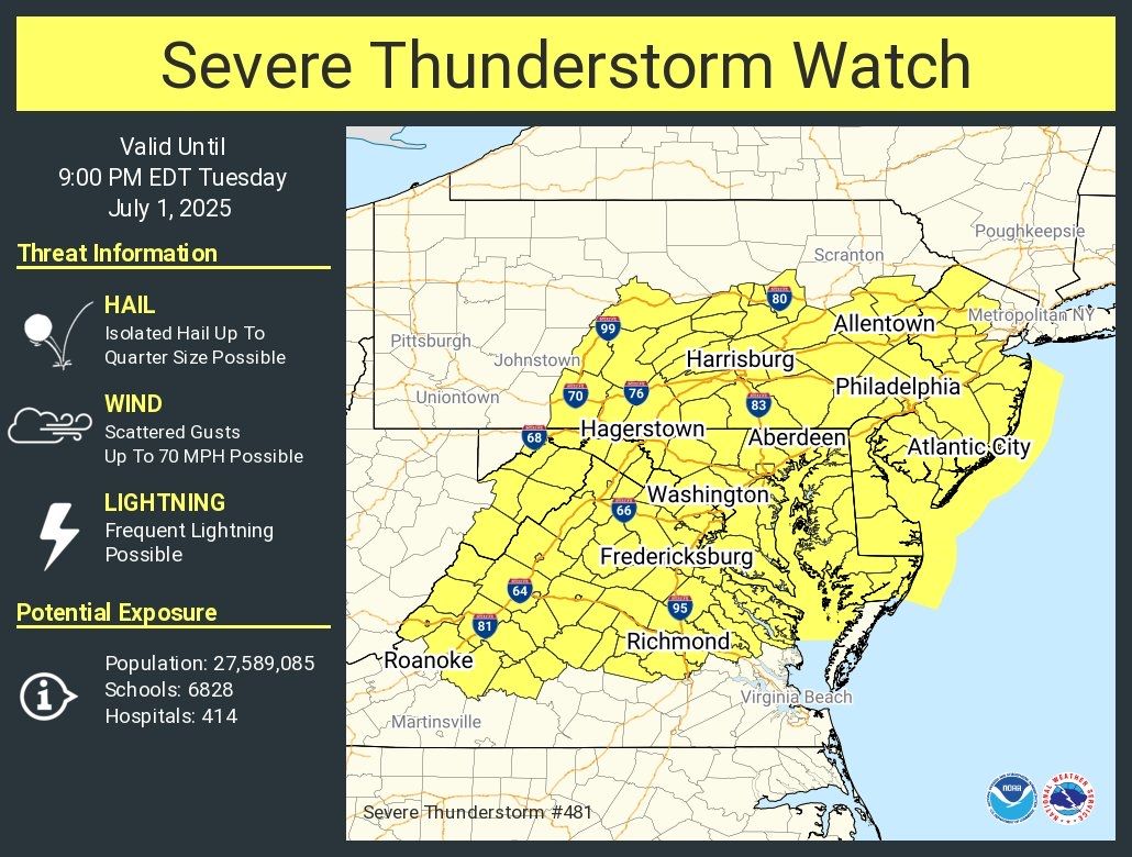
UNTIL 9pm TUE: Severe Thunderstorm Watch posted for Delmarva and the all of the mid-Atlantic metro areas. Damaging winds are the top concern, but isolated flash flooding is possible as well.

FLASH FLOODING POTENTIAL: Remnants of Chantal will move northeast across Delmarva this afternoon. The air is primed with tropical moisture and flash flooding will be possible. High winds and tornadoes are NOT expected - the focus will be on flooding concerns and impacted travel.


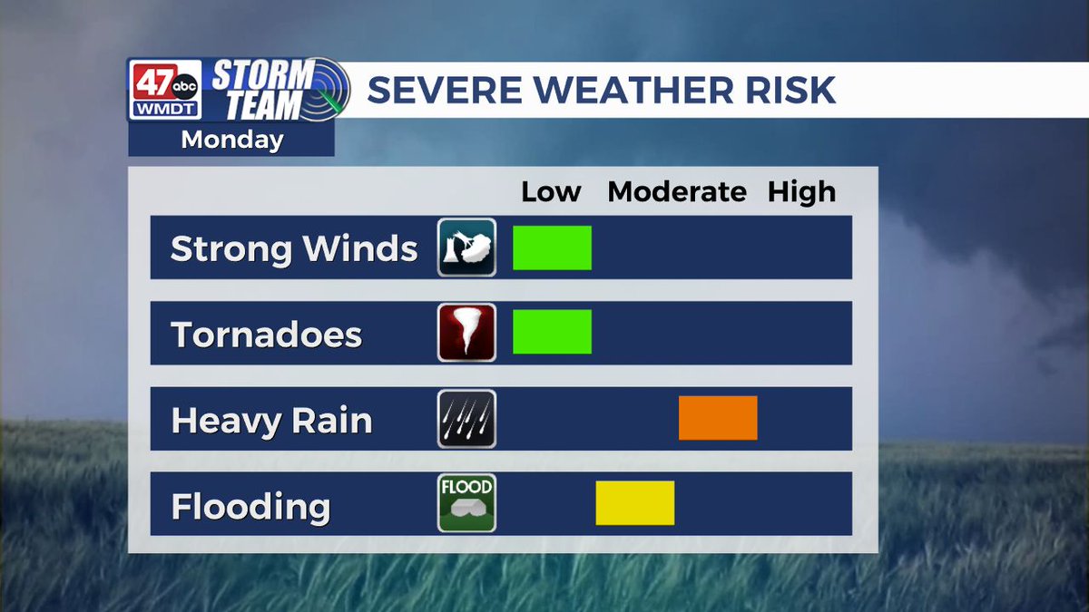
CHANTAL UPDATE: The good news is that this will be more of a nuisance for Delmarva, with the exception of a higher rip current risk at the beaches. The system is now a weak low, and it will track across the peninsula Monday aftn. Heavy rain could prompt isolated flooding.


👏👏👏 …we’re sad you’re leaving, but excited for your move. Now you get to send US the press releases!
Wrapped up a nearly seven year career with @47abc this week. I’m so grateful for all the opportunities I’ve had - from starting as a Web Producer, to moving to an on air role less than a year later. Next up: Public Relations Coordinator ☺️
Happy 4th, everyone! Have a fun and safe holiday weekend. youtu.be/vgune7Yl-dU
Here's the official damage survey from the US National Weather Service Philadelphia/Mount Holly of the brief tornado touchdown on Monday afternoon in Omar, DE.

NEW: Severe Thunderstorm Watch until 9pm. Covers most of Delmarva, and included DC-Baltimore-Richmond-Philadelphia metro areas.
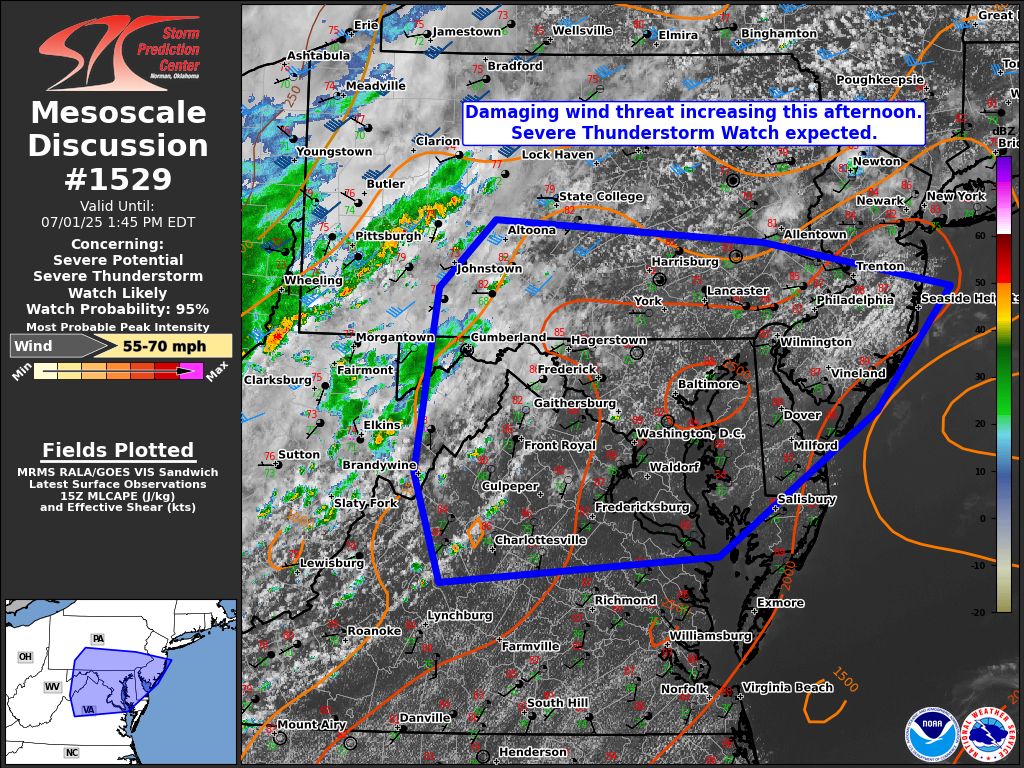
Upcoming Severe tstorm watch likely for parts of the Mid-Atlantic, including Delmarva
The National Weather Service confirms a brief, weak tornado touched down in Omar, DE, just outside of Dagsboro and Frankford in eastern Sussex county. Minor tree damage occurred along Omar Rd. Video shows a clearly visible funnel with rotation. #delaware #delmarva #tornado
NWS confirms a tornado touched down in Sussex county this afternoon, near Omar. Minor tree damage reported along Omar Rd. Video from Allison Marvel.
Flash flood warning for the 2nd day in a row for Delaware beaches and eastern Sussex co!