RadarOmega
@RadarOmega
iOS: http://bit.ly/RadarOmegaiOS Android: http://bit.ly/RadarOmegaAndroid RadarOmega Support: http://bit.ly/ROSupport Merch: https://radaromegamerch.myshopify.com/
Elevated to Critical fire weather conditions are possible today for parts of north-central Nevada. Surface winds between 15-20mph developing in the afternoon hours combined with low relative humidity values and dry fuels will support rapid fire spread. #NVwx #FireWx
The #NHC is monitoring an area of low pressure located off the southeastern U.S. coast. The system is forecast to move across the Florida Peninsula this week. As it moves into the Gulf, it should have a low (currently 10%) chance of formation. Regardless, heavy rain is possible.
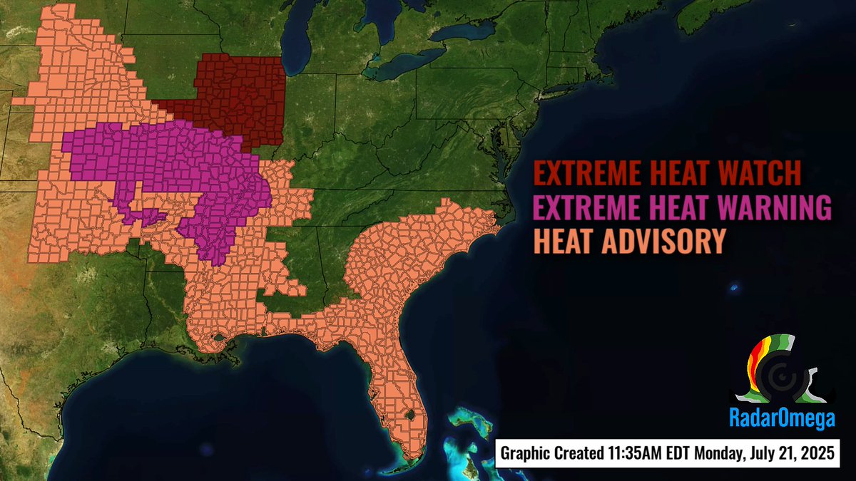
From the Gulf Coast to the Upper Midwest, dangerous heat indices are expected throughout the week. Over 80 million people are included in some form of heat-related weather alert - make sure you are protecting yourself and others in these hot conditions!
This satellite imagery depicts the growth of convection across parts of the central Plains, and subsequent development into a mesoscale convective vortex throughout the night! #KSwx #NEwx #IAwx
Tornado Warning including Maxwell IA, Colo IA, and Collins IA until 5:00 PM CDT #IAwx

WATCH POSSIBLE: Isolated strong to severe thunderstorms are possible across parts of southern Montana and northern Wyoming this afternoon and evening. #SPC says trends will be monitored, and a severe thunderstorm watch may be needed later this afternoon! #MTwx #WYwx
Three areas of the CONUS are under a slight risk (level 2/4) of excessive rainfall today! An upper-level ridging pattern over the southeastern U.S. continues to influence precipitation in the upper Midwest, Southwest, and Southeast with a risk of flash flooding.
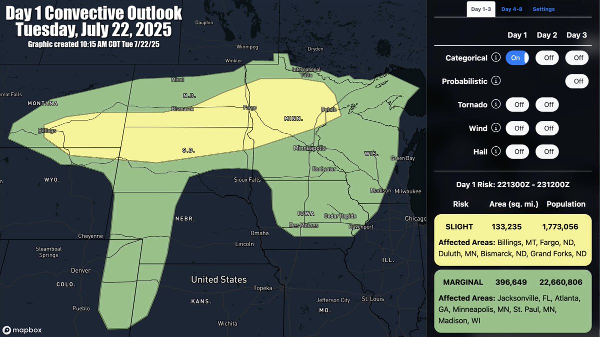
There is a slight risk of severe weather today across parts of the northern Plains into the upper Mississippi Valley! Scattered severe storms will be possible later today into tonight, with a threat for large hail, damaging winds, and possibly a tornado. #MTwx #SDwx #NDwx #MNwx
Supercells in southeastern Montana have quickly grown upscale into a linear complex this afternoon. Areas downstream of this linear storm complex are being monitored by the #SPC for an increasing severe wind threat given adequate buoyancy and increasingly favorable wind shear.…
Storm chasers Paige Berdomas and Bryce Shelton captured this view of a severe thunderstorm in far southeastern Montana moments ago this afternoon ⛈️ #MTwx 📸 @tornadopaigeyy, @BryceShelton01 📍 Near Broadus, MT
A stationary @cyclonePORT unit fixed atop Short Mountain, TN captured this view of thunderstorms moving through the area this afternoon 🌧️ #TNwx
A severe thunderstorm watch has been posed for parts of the northern High Plains valid until 11pm MDT tonight! Thunderstorms will continue to develop and intensify through the late afternoon, posing a risk of large hail and damaging wind gusts. A couple tornadoes are possible.…
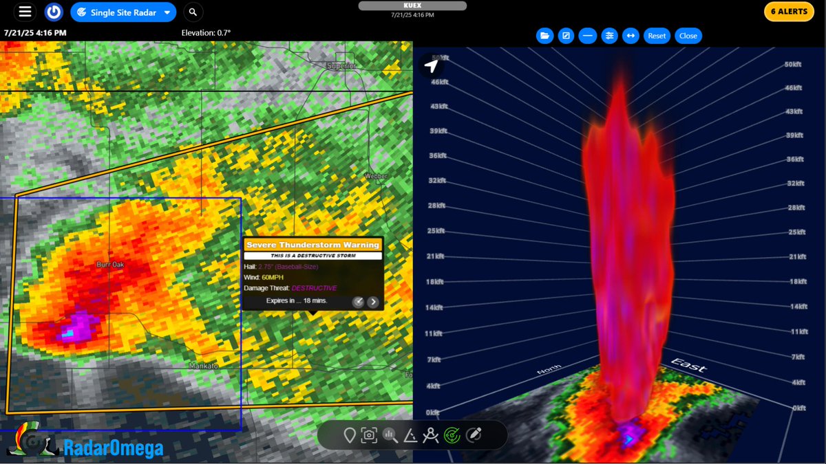
Severe Thunderstorm Warning continues for Mankato KS, Burr Oak KS and Formoso KS until 4:45 PM CDT. #KSwx This destructive storm will contain baseball sized hail!
Check out this timelapse of storms moving into Bowling Green this afternoon! #KYwx | @cyclonePORT
🌦️ Beautiful storm moving through Scottsville, Kentucky this afternoon! #KYwx @cyclonePORT
With dangerous heat expected across a swath of the CONUS this week, be sure to consider the heat index value! The combination of high temps and humidity can quickly cause heat-related illness. Be sure you are properly hydrated and prepared for any prolonged outdoor exposure!
A dangerous heat wave will continue to expand from the Deep South to parts of the Central Plains, MS Valley, and towards the OH Valley by mid-week. Widespread heat advisories and warnings are in effect, with triple digit heat index values expected for many areas.
The #NHC continues to monitor an area of low pressure about 700 miles east-southeast of the Lesser Antilles. Environmental conditions remain marginally conducive as this system moves west-northwestward. 48 hour formation chance: 20% 7 day formation chance: 20%
A dangerous heat wave will continue to expand from the Deep South to parts of the Central Plains, MS Valley, and towards the OH Valley by mid-week. Widespread heat advisories and warnings are in effect, with triple digit heat index values expected for many areas.
Severe thunderstorms will be possible across parts of the northern Plains this afternoon and evening. Per the #SPC, these storms will be capable of producing large hail, severe gusts, and perhaps a tornado or two. #MTwx #NDwx #SDwx