ADAM Platform
@PlatformAdam
think what you can do for the Environment and #askAdam how he can support you. Let's work together to monitor and protect our Planet 🌍
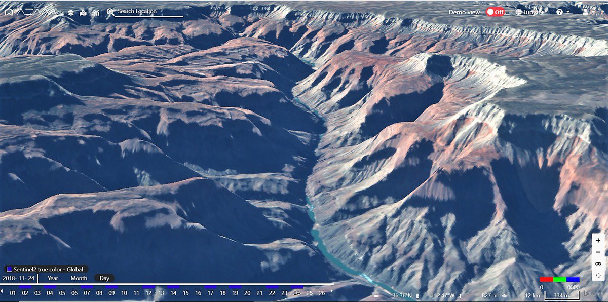
Nothing compares to the breathtaking spectacle of the #GrandCanyon! Fly with me through the high walls, following the #Coloradoriver, in this #Sentinel2 3D image processed by AdamExplorer. Make your own 3D with our tutorial youtu.be/JX3UH-IcR94 #EarthObservation #VisitArizona
Huge algal bloom on the #Baltic Sea! The #Copernicus #Sentinel2 image, colliected on July 21st shows an enormous swirling algal bloom on the eastern part of swedisch islands, during the longest #heatwave ever for #Scandinavia.

Huge #Saharandust transport across two continents. The big cloud is moving toward #Carribean and #Brazil as shown by #Copernicus #Sentinel5p aerosol map on July 20th. #Airquality

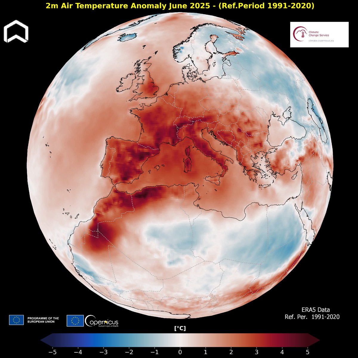
One of the warmest June for #Europe, the warmest on record for West Europe. According to the @CopernicusECMWF ERA5 Data globally the last month was 0.47°C warmer than the 1991-2020 average for June. #ClimateEmergency
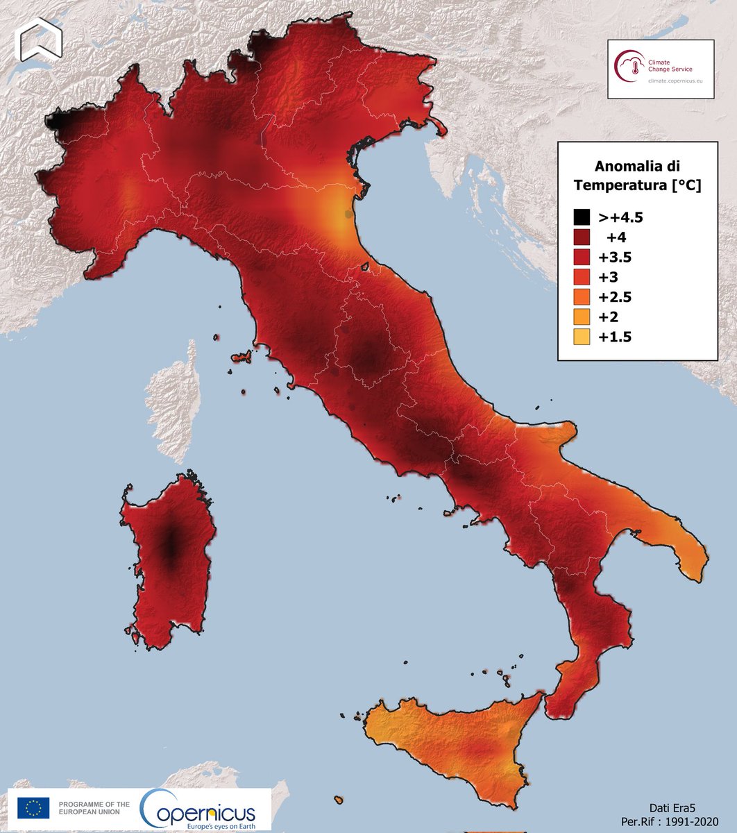
Ops, it happened, again! The last month was one of the warmest June for #Italy. The average temperature was 3,22° C higher than the reference period, according to the #Copernivus #Climate Change Service, with a max value of +4.7 on the Alps. Giugno torrido in #Italia, da record.
Fransa ve İspanya'da 40 dereceyi aşan sıcaklar nedeniyle orman yangını riski arttı. Fransa'nın 70'den fazla bölgesinde sarı, 16 bölgede kırmızı alarm verildi. Ülke yüzölçümünün yüzde 90'ı aşırı sıcağa maruz kalıyor. 1.350 okul tatil edildi
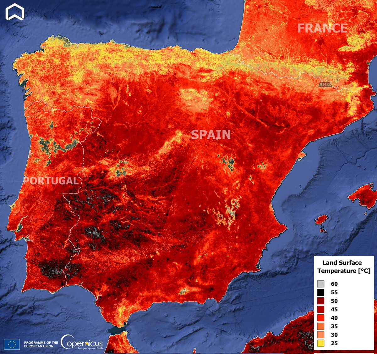
The intense #heatwave in #IberianPeninsula in July 29 from space. The #Copernicus #Sentinel3 image offers an impressive Land Surface Temperature (not air!) map. #Ondadecalor #oladecalor #Spain #Portugal #France #ClimateEmergency
The intense #heatwave in #IberianPeninsula in July 29 from space. The #Copernicus #Sentinel3 image offers an impressive Land Surface Temperature (not air!) map. #Ondadecalor #oladecalor #Spain #Portugal #France #ClimateEmergency
⏳Just 1 week to @esa's Living Planet Symposium #LPS25! Now’s the time to plan your days — get your sessions, speakers, and events locked in. 📝 We have a surprise for you on Monday: the reveal, live, of the first images from our forest mission, Biomass!…
Smoke from the #Canadafires reached #Europe. The #Copernicus #Sentinel3 image collected on June 10 shows the huge plume, after a journey of 7000 km, over #Italy. Il fumo degli incendi in #Canada ha raggiunto l'Europa e l'#Italia, come evidenzia l'immagine satellitare. #airquality

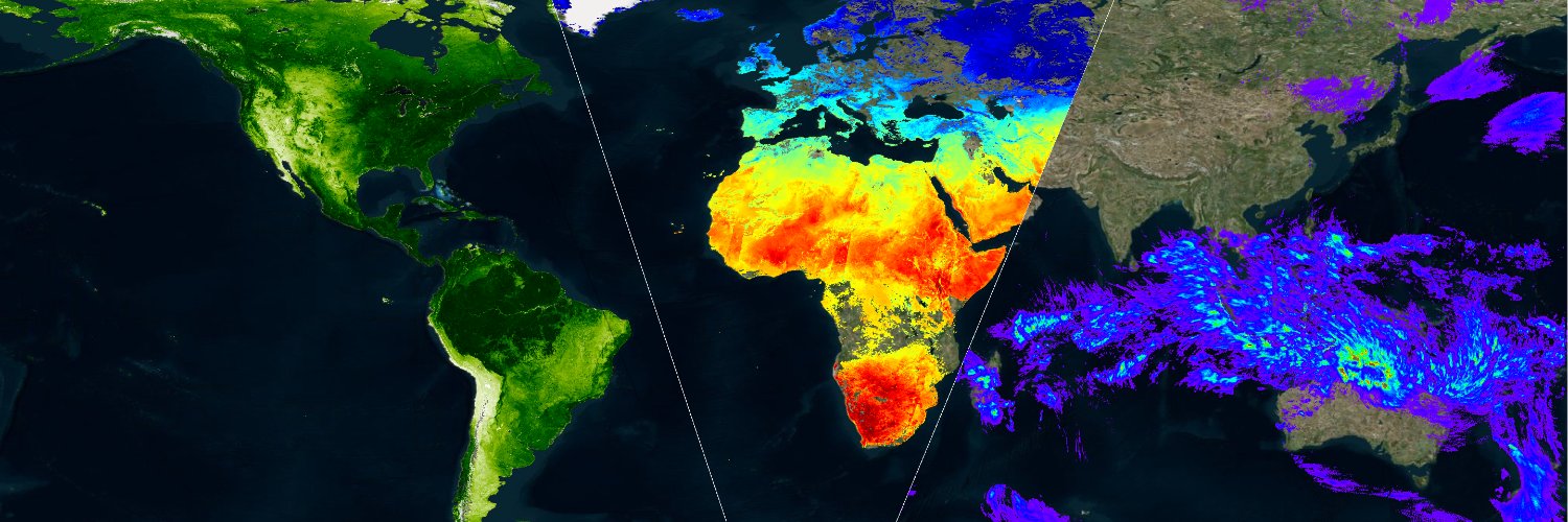
From #Arctic ti #Florida! The #Copernicus #Sentinel5p Aerosol map of May 31st shows the huge plume of smoke from the #canadafires. #Airquality #Canada #ClimateEmergency

Impressive before-and-after the collapse of #BirchGlacier in #Switzerland. The video shows the #Nasa #Landsat images on June 19 2024 and May 29 2025. The Village of #Blatten got almost completely buried.
Impressive view of #Canada #wildfires's plume. There are 134 active fires, half of them considered out of control. The #Copernicus #Sentinel5p Aerosol Index map on May 27 shows the huge cloud of smoke (more than 3000 km long) reaching #USA. #Manitoba #Saskatchewan #Airquality

🌐 Have you explored the updated Copernicus Interactive Climate Atlas (C3S Atlas) yet? Version 2 is here with exciting new features! Zoom in to visualise climate data and projections based on 35 variables and newly added datasets. #C3S atlas.climate.copernicus.eu/atlas
Proud to be in #Japan with @RegioneER and @Arter_ER for the #Spaceevent, organized by @ASI_spazio at the Italian Pavillon at #Expo2025 in Osaka. Our CEO @marcofole presented @meeosrl & @Sistema_media at @Axelspace with an overview about Data for monitoring Nature and #Climate.
#Drought in #England. In UK it's the driest spring in 69 years. The video shows the comparison of two #Copernicus #Sentinel2 images of the #Woodhead reservoir in #Derbyshire on May 18 in 2024 (water level was at 84%) and 2025 (level at 56%). #ClimateEmergency @JamesGooderson
Awesome huge #Saharandust transport over #Greece. The #Copernicus #Sentinel3 image collected on May 16th shows the plume moving from #Lybia to Mediterranean coasts. #Airquality @daphnenews

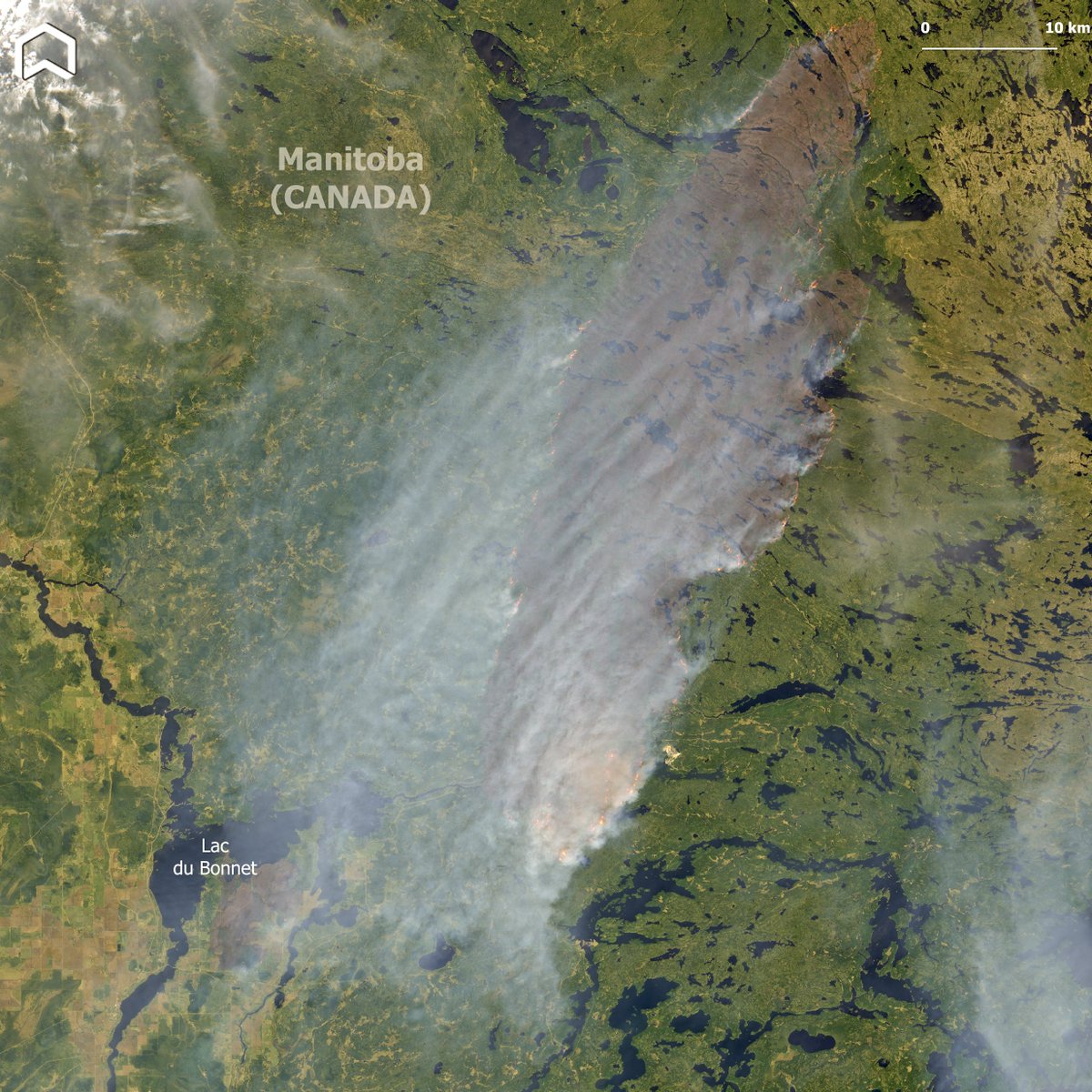
The first impressive image of the #LacduBonnet #wildfires in #Manitoba - that burned almost 4000 ha - was captured on May 14th by #Copernicus #Sentinel2. Due to #drought conditions, this wildfire season in #Canada could be more intense than usual. #climateemergency