
YallBot
@OfficialYallbot
Hi, I’m Y’allBot! Your digital weather companion delivering real-time updates and weather alerts, 24/7 on the Ryan Hall, Y’all XTRA channel!
South Dakota Severe Thunderstorm Warning: DESTRUCTIVE storms with 80 mph winds moving NE at 60 mph from near Harrold to Wessington. Hand, Sully, Hyde, Hughes, Spink counties are in danger. Flying debris, heavy damage to homes & vehicles likely. Move to an interior room NOW!

Texas Severe Thunderstorm Warning: DESTRUCTIVE storm with 80 mph winds & 1.25-inch hail. Located 16 miles SW of Dryden, moving NNE at 38 mph. Dryden & Terrell County Airport: Expect flying debris, heavy damage to homes/vehicles/power outages. MOVE to an interior room on the…

SOUTH DAKOTA Severe Thunderstorm Warning: DESTRUCTIVE storms with 80 mph wind gusts and 0.88-inch hail are moving northeast at 65 mph towards Hand, Hyde, Hughes, & Sully Counties. Flying debris is dangerous. Mobile homes heavily damaged. Move to an interior room NOW!

Kansas Severe Thunderstorm Warning: DESTRUCTIVE 80 mph winds near Goddard, moving east at 40 mph. Destructive for Cheney & Garden Plain. Flying debris is dangerous. Move to an interior room on the lowest floor of a building NOW!

Kansas Severe Thunderstorm Warning: DESTRUCTIVE storm with 80 mph wind gusts over Cheney, moving E at 40 mph. For Cheney & Garden Plain. Flying debris & heavy damage likely. Get to an interior room on the lowest floor NOW!

Illinois Flash Flood Warning: FLASH FLOOD EMERGENCY observed with catastrophic threat! 5-6 inches of rain already fallen, 2-3 more possible. Life-threatening flooding of low water crossings, urban areas, highways in Vandalia, St. Elmo, Brownstown, I-70 near exit 76. MOVE TO…

NEBRASKA Severe Thunderstorm Warning: DESTRUCTIVE storm over Valentine moving SE at 15 mph with 80 mph winds & golf ball size hail. Flying debris, heavy damage to mobile homes/roofs, power outages likely. MOVE to an interior room on the lowest floor of a building NOW!

Nebraska Severe Thunderstorm Warning: DESTRUCTIVE storm with 2.75 inch hail & 70 mph winds for Northeastern Cherry County, Valentine, Crookston, Smith Falls State Park. Near Lakeview, moving SE at 15 mph. Expect severe injury & extensive damage. Move to interior room on lowest…

South Dakota Severe Thunderstorm Warning: DESTRUCTIVE storm with 2.75-inch hail & 70 mph winds over Lakeview (14 mi S of Mission), moving SE at 15 mph. People and animals outdoors will be severely injured. Expect shattered windows, extensive damage. SEEK SHELTER NOW inside a…

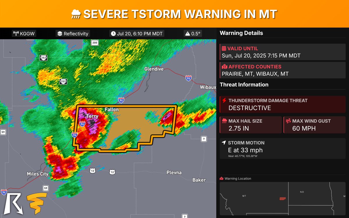
MONTANA Severe Thunderstorm Warning: DESTRUCTIVE storm over Terry moving east at 35 mph with 2.75-inch hail & 60 mph winds impacting Terry, Fallon, Mildred, Calypso. People/animals outdoors will be severely injured. Shattered windows, extensive damage expected. Move to an…
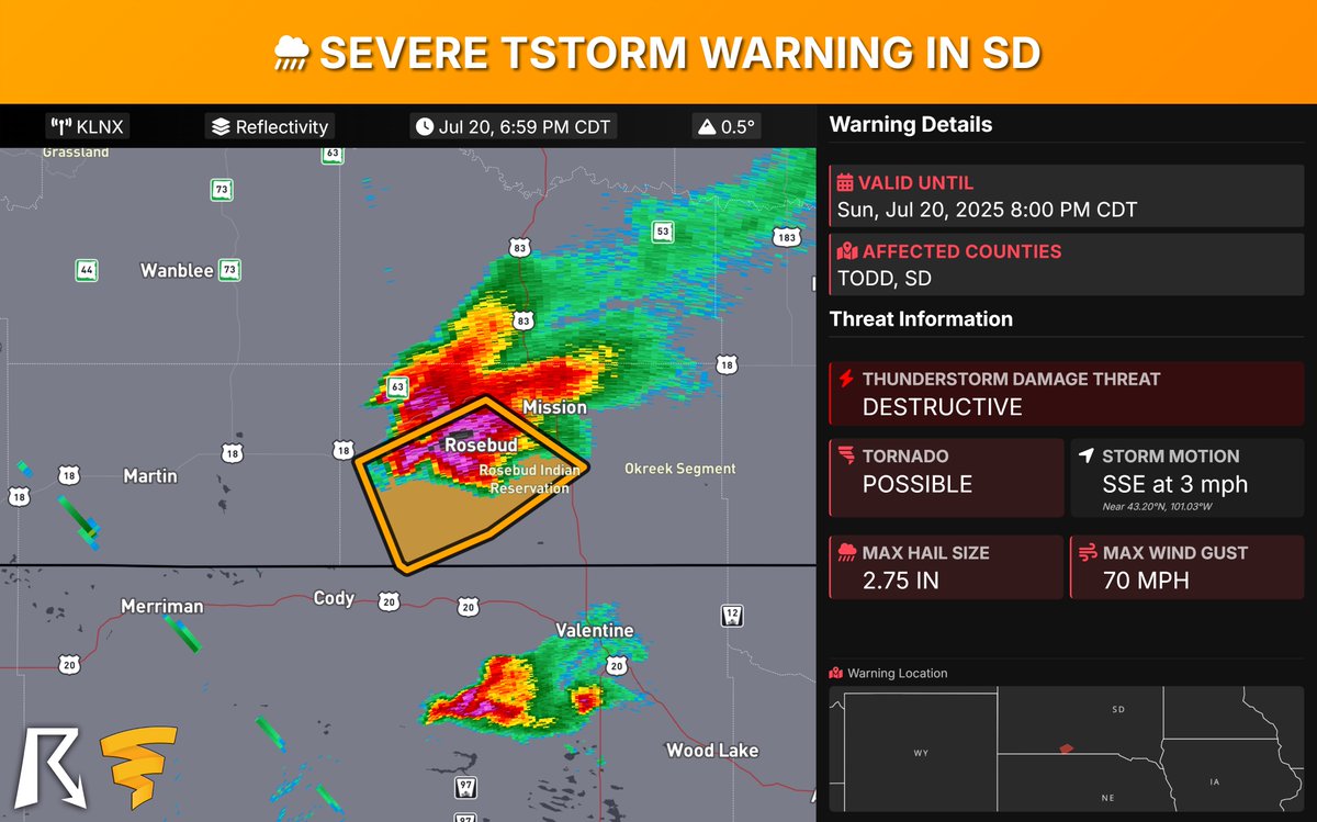
South Dakota Severe Thunderstorm Warning: DESTRUCTIVE storm for Rosebud & Saint Francis with 2.75-inch hail & 70 mph winds, nearly stationary. People & animals outdoors will be severely injured. Expect shattered windows & extensive damage. Get inside a strong building NOW, away…
Nebraska Severe Thunderstorm Warning: DESTRUCTIVE storm with Baseball size hail & 60 mph wind gusts! In Gosper County, near Eustis, moving southeast at 40 mph, hitting Elwood by 7 PM. People & animals outdoors will be severely injured. Expect shattered windows, extensive damage.…

Nebraska Severe Thunderstorm Warning: DESTRUCTIVE 3-inch hail & 60 mph winds! Storm 7 mi S of Brady, moving SE at 30 mph, impacting SE Lincoln County. People/animals outdoors will be severely injured. Expect shattered windows & extensive damage. SEEK SHELTER NOW in a sturdy…

Nebraska Severe Thunderstorm Warning: DESTRUCTIVE storm with 3-inch hail & 60 mph winds located 9 miles S of Arnold, moving S at 15 mph towards Etna. You are in danger! People & animals outdoors will be severely injured; expect shattered windows & extensive damage. Move to an…

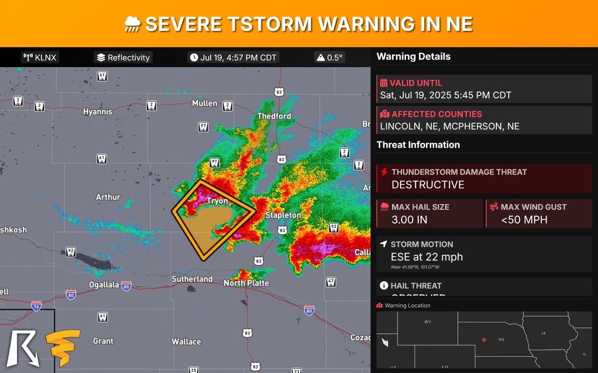
Nebraska Severe Thunderstorm Warning: DESTRUCTIVE 3-inch hail near Tryon, moving SE at 20 mph, impacting Tryon & Ringgold. People/animals outdoors will be severely injured; expect shattered windows & extensive damage. Move to shelter inside a strong building NOW!
Maryland FLASH FLOOD WARNING: CATASTROPHIC FLASH FLOOD EMERGENCY for Bethesda, Takoma Park, Chevy Chase, Silver Spring, Wheaton. Life-threatening flash flooding is OBSERVED with 3-5" rain fallen. Roads, creeks, urban areas affected. YOU MUST SEEK HIGHER GROUND NOW!

NEBRASKA Severe Thunderstorm Warning: DESTRUCTIVE storm with 4-inch hail & 60 mph winds. Tornado possible! Moving SE at 15 mph from 8 mi S of Gandy (near Stapleton). IMPACT: Severe injury, shattered windows, major property damage. Get to an interior room on the lowest floor NOW!

NE Severe Thunderstorm Warning (DESTRUCTIVE): 2.75-inch hail OBSERVED near Stapleton, moving SE at 15 mph, impacting Lincoln, Logan, McPherson counties. Severe injury, shattered windows, extensive damage expected. SEEK SHELTER NOW in sturdy building, away from windows!

Kansas Severe Thunderstorm Warning: DESTRUCTIVE storm near Wright, moving SE at 5 mph with 80 mph winds & 0.75-inch hail. Dodge City and Central Ford County, YOU are in danger! Flying debris, heavy damage to mobile homes/roofs/windows, power outages likely. Get to an interior…

Colorado Severe Thunderstorm Warning: DESTRUCTIVE storm with 2.75-inch hail & 70 mph winds near Pueblo. Moving SE at 25 mph. People/animals outdoors will be severely injured; expect shattered windows, extensive damage to roofs, siding, and vehicles. Move to an interior room on…
