
NashSevereWx
@NashSevereWx
Community Supported Local Weather, Nashville & Williamson Co ° @NashvilleScene Readers' Poll Best Twitter Acct '14-'24 ° 2016 & 2022 NWA W. J. Bennett Award
*Looks like we get A Sky Full of Stars tonight, lower rain chances rest of the work week *Heat Advisory continues thru Wednesday evening, heat index values around 109° likely New blog here nashvillesevereweather.com/2025/07/22/hop…

Feeling pretty confident that we've seen the last of the storms for today...hoping for no surprises at Coldplay. But, you know how that goes.
*Hottest temperatures so far this year likely next week, as high temps near 100° *Daily rain and storm chances stay fairly low thru middle of next week New blog here nashvillesevereweather.com/2025/07/25/sum…

*Our brutal heat continues thru the end of July, high temps near 100° possible next week *Daily rain & storm chances remain low, ~10-20% during the afternoon and evening New blog here nashvillesevereweather.com/2025/07/24/bru…

Looking ahead, NWS is seeing indications that this heat wave will likely be a long-duration event. The high pressure ridge causing it will be strengthening into the middle of next week, so it appears excessive heat conditions could worsen after this weekend. Heat indices above…
*Heat Advisory continues thru 8p Thursday with heat index values near 108° *Daily rain & storm chances stay relatively low over the next several days Deets here nashvillesevereweather.com/2025/07/23/hea…

This deserves another snow picture. This one from January 22.
Our heat advisory just got extended…now expires at 8:00 pm Thursday. So there’s that.
Our heat advisory just got extended…now expires at 8:00 pm Thursday. So there’s that.
Heaviest storm now over TS coming into Spring Hill. Head inside until the threat of lightning passes. 3:28 pm

In short, no. These things build, storm, then rain themselves out....typically in an hour or so...unless another one builds in behind it.
Do you know how long is this gonna last ???
Strongest storm is meandering around Donelson/Hermitage/BNA. Not a good day on I-40. Watch for ponding on the roads for sure. Guardrails steal bumpers in this kind of rain. 2:34 pm

New Flood Advisory for E Davidson County. Avoid water covered roadways.


Storms continue to develop and generally move south. Lightning is being tossed outside the rain, so be aware if you’re anywhere near these storms…head inside. 2:01 pm
A lot of lightning with this storm over Glencliff, headed into Crieve Hall. Some gusty winds with this too. 1:24 pm

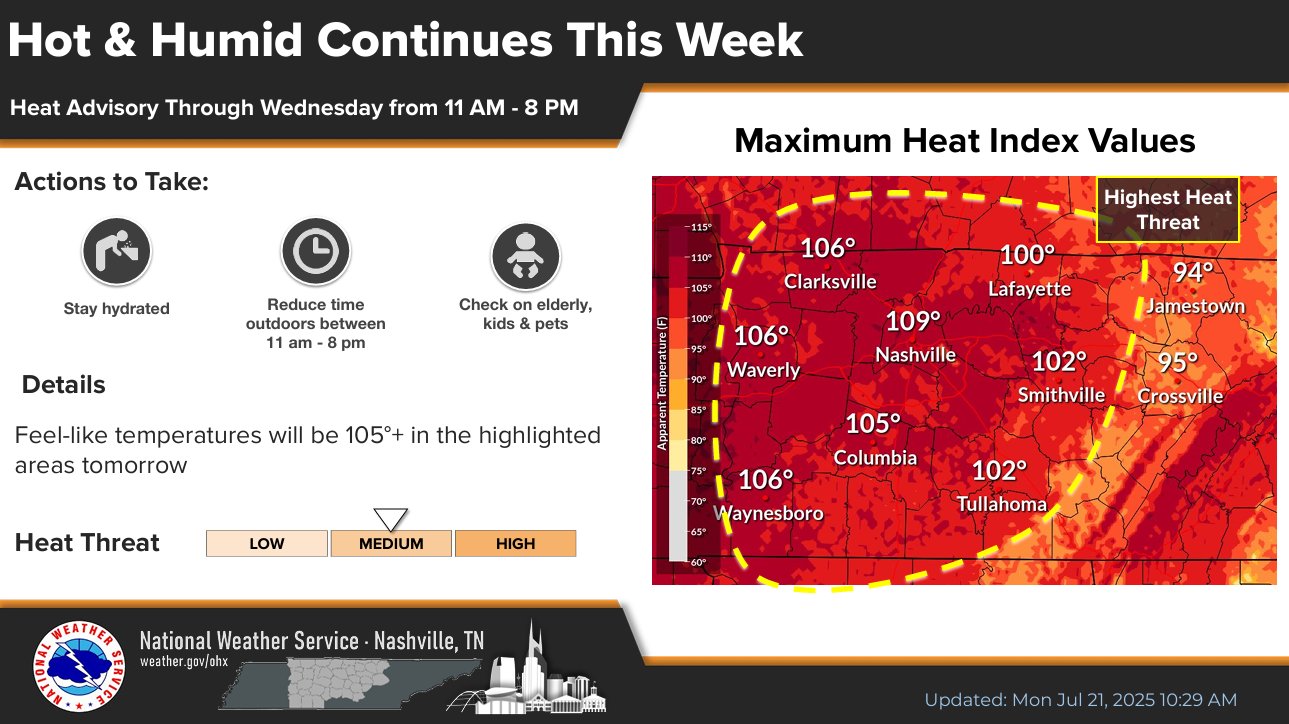
*Heat Advisory remains thru 8p Wednesday, heat index values up to 108° possible *Rain & storm chances relax a bit by midweek. For now, Coldplay concert looks dry but hot Late night blog up here, because earlier storms sidetracked me nashvillesevereweather.com/2025/07/21/hea…
Attached HRRR thinks this was the last round of storms for tonight. We'll see. Still some storms around Clarksville heading our way.
Almost everyone got some rain today. Heaviest amounts down in SW Williamson and in the Oak Hill area. Only place that missed out is way down toward Allisona. These are 3-hour rainfall totals, radar estimated.

A co-worker of mine sent this in....fell right outside my Oak Hill office. This was part of that downburst that went through Oak Hill/Crieve Hall a couple of hours ago.
