NWS Wilmington, NC
@NWSWilmingtonNC
Official Twitter Account for National Weather Service Wilmington, NC. Details: https://www.weather.gov/nws_x
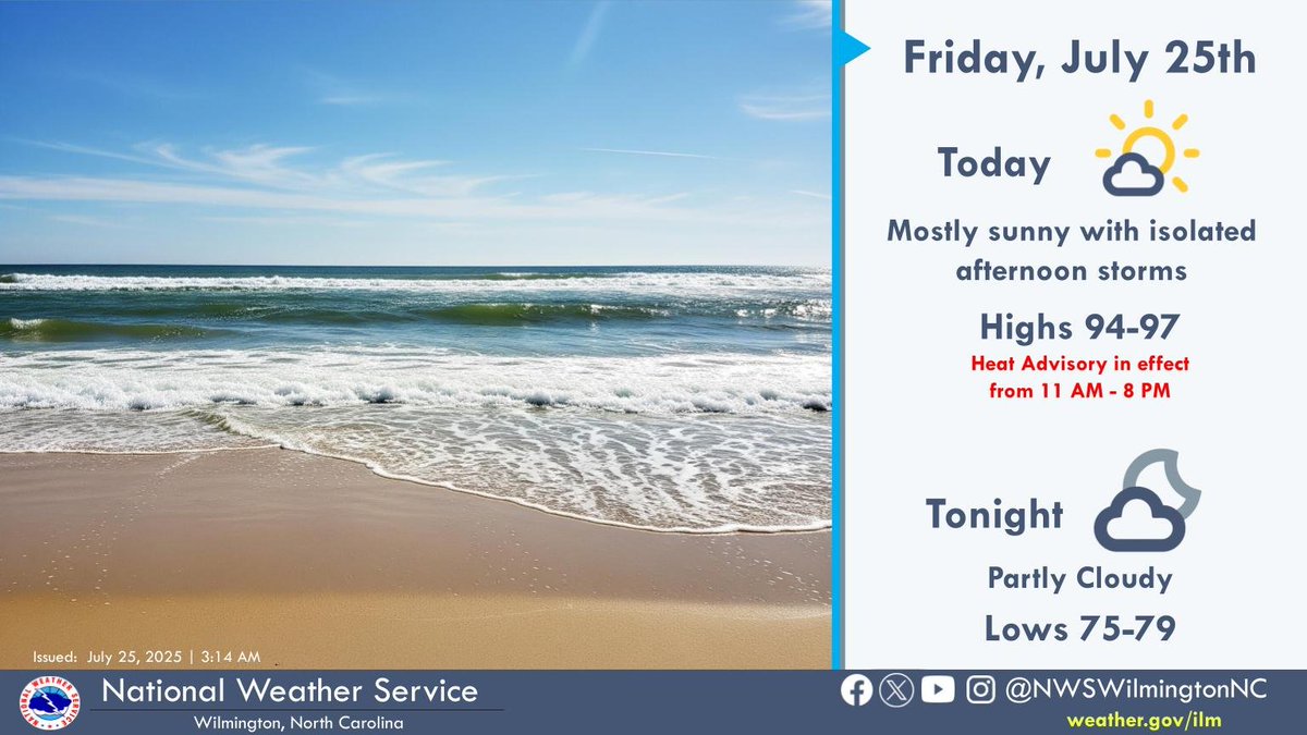
Hot and humid weather returns today with highs in the upper 90s. A Heat Advisory is in effect for Friday with an Extreme Heat Watch for dangerous heat through the weekend.

Here's a look at the heat risk headed into the weekend and early next week as we'll deal with our second wave of dangerous heat! ☀️ #ILMwx #SCwx #NCwx
Showers along the coast this morning will transition inland this afternoon. Enjoy the cooler temperatures today, dangerous heat and oppressive humidity return this weekend!


Seasonable weather today but the heat will be coming back with a vengeance this weekend!

Mostly sunny today, with a chance of showers and thunderstorms along the coast. Highs in the upper 80s to lower 90s. #ncwx #scwx #ilmwx


A special weather statement has been issued for Socastee SC and Toddville SC until 2:30 PM EDT #SCwx

A special weather statement has been issued for Andrews SC until 2:30 PM EDT #SCwx

A special weather statement has been issued for Myrtle Beach SC until 2:00 PM EDT #SCwx

Special Marine Warning continues for the Waters from Murrells Inlet NC to South Santee River SC from 20 to 40 nm and Coastal waters from Murrells Inlet to South Santee River SC out 20 nm until 1:45 PM EDT

Special Marine Warning continues for the Waters from Murrells Inlet NC to South Santee River SC from 20 to 40 nm and Coastal waters from Murrells Inlet to South Santee River SC out 20 nm until 1:45 PM EDT

Special Marine Warning including the Waters from Murrells Inlet NC to South Santee River SC from 20 to 40 nm and Coastal waters from Murrells Inlet to South Santee River SC out 20 nm until 1:45 PM EDT

A special weather statement has been issued for Pawleys Island SC and Plantersville SC until 12:30 PM EDT #SCwx

A special weather statement has been issued for Pawleys Island SC until 12:15 PM EDT #SCwx

Scattered showers & thunderstorms are expected to develop this afternoon, especially near the coast and in our SC zones in the vicinity of a weak cold front. Heavy rain capable of producing isolated flash flooding & lightning strikes are the primary concerns. Stay weather aware!

A weak front in the area will bring showers and storms this afternoon, especially closer to the coast. Highs in the upper 80s to lower 90s. #ncwx #scwx #ilmwx


A special weather statement has been issued for Georgetown County, SC until 3:30 PM EDT #SCwx
