NWS Twin Cities
@NWSTwinCities
Official X account for the National Weather Service Twin Cities, Minnesota. Details: http://weather.gov/twincities
Heat and humidity returns this weekend. Heat indices will exceed 100 in western MN Saturday. Dangerous heat spreads spreads east Sunday with heat indices near or over 100 area-wide. Storms are likely Sunday night with the possibility of some storms being severe. #mnwx #wiwx

Warmer and more humid weather will gradually build, with Sunday being the hottest day of the three days. Some areas may have heat indices greater than 100. There is also a chance of storms Sunday afternoon and evening.

Quiet weather to open the weekend! An Air Quality Alert continues through Friday. Heat, humidity, and storm chances return by Sunday.
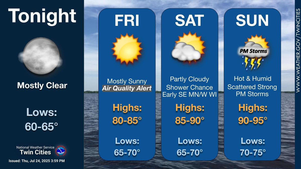
Less humid and rain-free today through Friday with highs in the low-mid 80s. Elevated humidity levels return Saturday-Monday with highs in the lower 80s to lower 90s. Isolated to scattered showers and thunderstorms possible over the weekend. #mnwx #wiwx

Watch out for flooded streets tonight in & around Mankato, especially on the west site of town. If you have any reports of flooding to send our way, we would really appreciate it! #mnwx
Flash Flood Warning including Mankato MN, North Mankato MN and Eagle Lake MN until 2:45 AM CDT
Flash Flood Warning including Mankato MN, North Mankato MN and Eagle Lake MN until 2:45 AM CDT

A special weather statement has been issued for Owatonna MN, Albert Lea MN and Fairmont MN until 9:15 PM CDT

Tornado Warning including Janesville MN and Saint Clair MN until 8:00 PM CDT

Scattered storms possible across south-central MN into western WI this evening into tonight. Storms end early tomorrow however wildfire smoke with impact air quality Thursday into Friday. Most of the weekend looks dry although highs will be warm near 90. #mnwx #wiwx

A special weather statement has been issued for Medford MN and Morristown MN until 3:30 PM CDT

We are noticing some embedded rotation between Mondovi and Eleva and moving into the warned area. A tornado may be possible with this storm. #wiwx
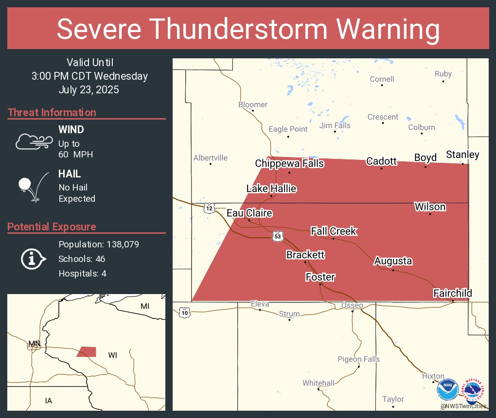
Severe Thunderstorm Warning including Eau Claire WI, Chippewa Falls WI and Altoona WI until 3:00 PM CDT
Severe Thunderstorm Warning including Eau Claire WI, Chippewa Falls WI and Altoona WI until 3:00 PM CDT
Periods of heavy rain and storms will continue through tonight. Rainfall rates nearing 2" possible which may lead to urban flooding and ponding. The strongest threat for severe storms is mainly across south-central MN to southern MN from 4 PM into late tonight. #mnwx #wiwx

Flash Flood Warning including Maple Grove MN, Coon Rapids MN and Blaine MN until 2:15 PM CDT

A special weather statement has been issued for Saint Cloud MN, Sartell MN and Sauk Rapids MN until 1:15 PM CDT

Due to ongoing thunderstorms, we will NOT be conducting the NOAA Weather Radio weekly test today. #mnwx #wiwx
A special weather statement has been issued for Renville MN, Sacred Heart MN and Danube MN until 12:15 PM CDT

Flash Flood Warning including Sartell MN, Albany MN and Avon MN until 1:15 PM CDT
